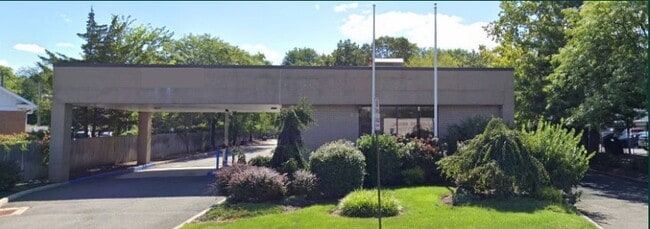
Property Record
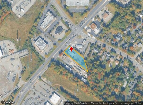
28 Eisenhower Pky, Roseland, NJ 07068
Current Lease Availabilities
NEARBY LISTINGS FOR SALE OR LEASE
Property Detail
28 Eisenhower Pky
Newark, NJ
100X310
18-00032-0000-00002
Essex
Commercialnec
New Jersey
X
2
34013C0079G
0.71 AC
2023
Suburban Essex/Rt 280
2025
Northern New Jersey
020902
DEMOGRAPHICS near 28 Eisenhower Pky
1 Mile
3 Mile
5 Mile
2024 Total Population
4,351
61,805
165,066
2029 Population
4,284
61,390
164,329
Pop Growth 2024-2029
(1.54%)
(0.67%)
(0.45%)
Average Age
46
43
43
2024 Total Households
1,704
22,267
59,797
HH Growth 2024-2029
(2.17%)
(0.91%)
(0.59%)
Median Household Inc
$142,187
$138,882
$140,609
Avg Household Size
2.50
2.70
2.70
2024 Avg HH Vehicles
2.00
2.00
2.00
Median Home Value
$678,688
$684,055
$644,655
Median Year Built
1976
1965
1965
Nearby Places
Map Layers
Map Styles
 Street
 Aerial
- Restaurants
- Banks
- Shops
- Fitness
- Groceries
PUBLIC TRANSPORTATION
COMMUTER RAIL
Orange (Morris & Essex Gladstone Branch - NJ Transit Commuter Rail (NJ Transit), Morris & Essex Morristown Line - NJ Transit Commuter Rail (NJ Transit))
DRIVE
WALK
Distance
Orange (Morris & Essex Gladstone Branch - NJ Transit Commuter Rail (NJ Transit), Morris & Essex Morristown Line - NJ Transit Commuter Rail (NJ Transit))
12 min
7.5 mi
Highland Avenue (Morris & Essex Gladstone Branch - NJ Transit Commuter Rail (NJ Transit), Morris & Essex Morristown Line - NJ Transit Commuter Rail (NJ Transit))
DRIVE
WALK
Distance
Highland Avenue (Morris & Essex Gladstone Branch - NJ Transit Commuter Rail (NJ Transit), Morris & Essex Morristown Line - NJ Transit Commuter Rail (NJ Transit))
12 min
8.0 mi
AIRPORT
Newark Liberty International
DRIVE
WALK
Distance
Newark Liberty International
26 min
17.2 mi
LaGuardia
DRIVE
WALK
Distance
LaGuardia
53 min
36.8 mi
John F Kennedy International
DRIVE
WALK
Distance
John F Kennedy International
64 min
47.8 mi
Freight Ports
Maher Terminal
DRIVE
WALK
Distance
Maher Terminal
30 min
17.5 mi
Nearby Properties
Address
Land Use
TOTAL SIZE
Lot Size
Zoning
Address
Land Use
TOTAL SIZE
Lot Size
Zoning
37.70 AC
R-6
Address
Land Use
TOTAL SIZE
Lot Size
Zoning
48.85 AC
R-3B
Address
Land Use
TOTAL SIZE
Lot Size
Zoning
98.27 AC
AH1
Address
Land Use
TOTAL SIZE
Lot Size
Zoning
19.70 AC
R-4
Address
Land Use
TOTAL SIZE
Lot Size
Zoning
13 AC
RM
Address
Land Use
TOTAL SIZE
Lot Size
Zoning
101.44 AC
OB-1
Address
Land Use
TOTAL SIZE
Lot Size
Zoning
32.34 AC
RA
Address
Land Use
TOTAL SIZE
Lot Size
Zoning
147,871 SF
26.50 AC
PB-3
Address
Land Use
TOTAL SIZE
Lot Size
Zoning
20.97 AC
R-2
Address
Land Use
TOTAL SIZE
Lot Size
Zoning
55.77 AC
OB-1
Address
Land Use
TOTAL SIZE
Lot Size
Zoning
51.24 AC
OB-2
Address
Land Use
TOTAL SIZE
Lot Size
Zoning
119,552 SF
129 AC
I1A
Address
Land Use
TOTAL SIZE
Lot Size
Zoning
17.90 AC
B-2
Address
Land Use
TOTAL SIZE
Lot Size
Zoning
8.79 AC
R-1
Address
Land Use
TOTAL SIZE
Lot Size
Zoning
55.22 AC
R-2
Address
Land Use
TOTAL SIZE
Lot Size
Zoning
336,832 SF
46.12 AC
R-L
Address
Land Use
TOTAL SIZE
Lot Size
Zoning
41.84 AC
OB-1
Address
Land Use
TOTAL SIZE
Lot Size
Zoning
35.55 AC
P-B2
Address
Land Use
TOTAL SIZE
Lot Size
Zoning
61.69 AC
Address
Land Use
TOTAL SIZE
Lot Size
Zoning
19.70 AC
R-3
Address
Land Use
TOTAL SIZE
Lot Size
Zoning
6.01 AC
OB-2
Address
Land Use
TOTAL SIZE
Lot Size
Zoning
49.53 AC
P
Address
Land Use
TOTAL SIZE
Lot Size
Zoning
25.40 AC
I-3
Address
Land Use
TOTAL SIZE
Lot Size
Zoning
38.40 AC
Address
Land Use
TOTAL SIZE
Lot Size
Zoning
28.06 AC
OB-3
Address
Land Use
TOTAL SIZE
Lot Size
Zoning
25.71 AC
Address
Land Use
TOTAL SIZE
Lot Size
Zoning
259,325 SF
13.62 AC
I1A
Address
Land Use
TOTAL SIZE
Lot Size
Zoning
1,443 SF
165.75 AC
I-R2
Address
Land Use
TOTAL SIZE
Lot Size
Zoning
21.31 AC
R-6
Address
Land Use
TOTAL SIZE
Lot Size
Zoning
97,771 SF
9.65 AC
C-I
The World's #1 Commercial Real Estate Marketplace
Connect with us
© 2026 CoStar Group
The information above has been obtained from sources believed reliable. While we do not doubt its accuracy we have not verified it and make no guarantee, warranty or representation about it. It is your responsibility to independently confirm its accuracy and completeness. Any projections, opinions, assumptions, or estimates used are for example only and do not represent the current or future performance of the property. The value of this transaction to you depends on tax and other factors which should be evaluated by your tax, financial, and legal advisors. You and your advisors should conduct a careful, independent investigation of the property to determine to your satisfaction the suitability of the property for your needs.