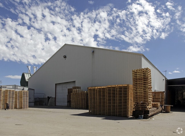
Property Record
521 S 1550 W, Spanish Fork, UT 84660


NEARBY LISTINGS FOR SALE OR LEASE
Property Detail
521 S 1550 W
Provo-Orem, UT
COM W 1215.43 FT & S 212.01 FT & S 47 DEG 0726W 177.5 FT FR E 1/4 COR SEC 23,, T8S, R2E, SLM; S 2111W 1930.10 FT; N 51 DEG 1704W 677.21 FT; N 2 DEG 3846E 985.31 FT; N 38 DEG 3133E 307.91 FT; N 47 DEG 0726E 413.50 FT; TO BEG. AREA 17.30 ACRES
25-016-0025
Utah
Commercialnec
Utah
2024
17.30 AC
2025
Utah County
003301
Salt Lake City
31,830 SF
DEMOGRAPHICS near 521 S 1550 W
1 Mile
3 Mile
5 Mile
2024 Total Population
6,102
33,680
83,733
2029 Population
7,125
39,360
98,300
Pop Growth 2024-2029
+ 16.76%
+ 16.86%
+ 17.40%
Average Age
29
32
32
2024 Total Households
1,634
9,513
22,843
HH Growth 2024-2029
+ 17.07%
+ 17.17%
+ 17.74%
Median Household Inc
$94,623
$88,975
$93,391
Avg Household Size
3.70
3.50
3.60
2024 Avg HH Vehicles
3.00
3.00
3.00
Median Home Value
$407,320
$407,772
$439,412
Median Year Built
2003
1995
2002
Nearby Places
Map Layers
Map Styles
 Street
 Aerial
- Restaurants
- Banks
- Shops
- Fitness
- Groceries
PUBLIC TRANSPORTATION
AIRPORT
Provo Municipal
DRIVE
WALK
Distance
Provo Municipal
21 min
12.3 mi
Freight Ports
Port of Stockton
DRIVE
WALK
Distance
Port of Stockton
770 min
748.8 mi
Nearby Properties
Address
Land Use
TOTAL SIZE
Lot Size
Zoning
Address
Land Use
TOTAL SIZE
Lot Size
Zoning
44,552 SF
29.78 AC
Address
Land Use
TOTAL SIZE
Lot Size
Zoning
565,605 SF
20 AC
Address
Land Use
TOTAL SIZE
Lot Size
Zoning
92,323 SF
8.96 AC
Address
Land Use
TOTAL SIZE
Lot Size
Zoning
204,890 SF
15.28 AC
Address
Land Use
TOTAL SIZE
Lot Size
Zoning
271,536 SF
11.80 AC
Address
Land Use
TOTAL SIZE
Lot Size
Zoning
243,888 SF
32.23 AC
Address
Land Use
TOTAL SIZE
Lot Size
Zoning
159,679 SF
12.91 AC
Address
Land Use
TOTAL SIZE
Lot Size
Zoning
322,432 SF
29.36 AC
Address
Land Use
TOTAL SIZE
Lot Size
Zoning
149,046 SF
12.10 AC
Address
Land Use
TOTAL SIZE
Lot Size
Zoning
134,564 SF
8.03 AC
Address
Land Use
TOTAL SIZE
Lot Size
Zoning
112,094 SF
10.34 AC
Address
Land Use
TOTAL SIZE
Lot Size
Zoning
729,831 SF
66.60 AC
RA5
Address
Land Use
TOTAL SIZE
Lot Size
Zoning
120,141 SF
7.71 AC
Address
Land Use
TOTAL SIZE
Lot Size
Zoning
96,665 SF
22.25 AC
Address
Land Use
TOTAL SIZE
Lot Size
Zoning
171,101 SF
11.65 AC
Address
Land Use
TOTAL SIZE
Lot Size
Zoning
93,850 SF
6.61 AC
Address
Land Use
TOTAL SIZE
Lot Size
Zoning
181,993 SF
5.01 AC
Address
Land Use
TOTAL SIZE
Lot Size
Zoning
71,691 SF
5.52 AC
Address
Land Use
TOTAL SIZE
Lot Size
Zoning
110,762 SF
6.08 AC
Address
Land Use
TOTAL SIZE
Lot Size
Zoning
62,203 SF
2.13 AC
Address
Land Use
TOTAL SIZE
Lot Size
Zoning
37,031 SF
4.73 AC
Address
Land Use
TOTAL SIZE
Lot Size
Zoning
51,530 SF
4.58 AC
Address
Land Use
TOTAL SIZE
Lot Size
Zoning
99,114 SF
3.67 AC
Address
Land Use
TOTAL SIZE
Lot Size
Zoning
26.42 AC
Address
Land Use
TOTAL SIZE
Lot Size
Zoning
92,026 SF
9.99 AC
Address
Land Use
TOTAL SIZE
Lot Size
Zoning
51,611 SF
9.81 AC
Address
Land Use
TOTAL SIZE
Lot Size
Zoning
89,591 SF
9.01 AC
Address
Land Use
TOTAL SIZE
Lot Size
Zoning
89,597 SF
5.92 AC
Address
Land Use
TOTAL SIZE
Lot Size
Zoning
14,844 SF
1.76 AC
Address
Land Use
TOTAL SIZE
Lot Size
Zoning
84,240 SF
3.67 AC
The World's #1 Commercial Real Estate Marketplace
Connect with us
© 2025 CoStar Group
The information above has been obtained from sources believed reliable. While we do not doubt its accuracy we have not verified it and make no guarantee, warranty or representation about it. It is your responsibility to independently confirm its accuracy and completeness. Any projections, opinions, assumptions, or estimates used are for example only and do not represent the current or future performance of the property. The value of this transaction to you depends on tax and other factors which should be evaluated by your tax, financial, and legal advisors. You and your advisors should conduct a careful, independent investigation of the property to determine to your satisfaction the suitability of the property for your needs.