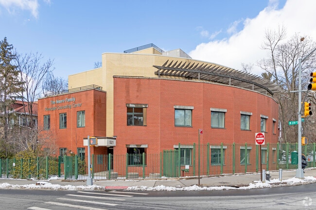
Property Record
521 W 239Th St, Bronx, NY 10463

NEARBY LISTINGS FOR SALE OR LEASE
Property Detail
521 W 239Th St
05909-0008
Map Hudson Park
Religious
Bronx
X
New York
34003C0220H
8
0
0.19 AC
2025
Bronx
030701
Westchester/So Connecticut
14,809 SF
New York-Jersey City-White Plains, NY-NJ
DEMOGRAPHICS near 521 W 239Th St
1 mile
3 mile
5 mile
2024 Total Population
70,351
659,903
1,714,878
2029 Population
67,919
622,677
1,611,861
Pop Growth 2024-2029
(3.46%)
(5.64%)
(6.01%)
Average Age
43
39
39
2024 Total Households
29,203
239,386
624,630
HH Growth 2024-2029
(3.95%)
(6.23%)
(6.44%)
Median Household Inc
$75,325
$48,889
$49,937
Avg Household Size
2.20
2.60
2.60
2024 Avg HH Vehicles
1.00
1.00
1.00
Median Home Value
$441,616
$495,394
$477,053
Median Year Built
1956
1948
1951
Nearby Places
Map Layers
Map Styles
 Street
 Aerial
Transit
 Traffic
 Biking
Places
Listings with unknown addresses are not visible on the map
- Restaurants
- Banks
- Shops
- Fitness
- Groceries
PUBLIC TRANSPORTATION
TRANSIT/SUBWAY
238 Street (1 - New York MTA Subway (The Subway))
Drive
Walk
Distance
238 Street (1 - New York MTA Subway (The Subway))
4 min
11 min
0.6 mi
Van Cortlandt Park-242 Street (1 - New York MTA Subway (The Subway))
Drive
Walk
Distance
Van Cortlandt Park-242 Street (1 - New York MTA Subway (The Subway))
4 min
17 min
0.9 mi
231 Street (1 - New York MTA Subway (The Subway))
Drive
Walk
Distance
231 Street (1 - New York MTA Subway (The Subway))
2 min
18 min
0.9 mi
COMMUTER RAIL
Spuyten Duyvil Station (Hudson Line - Metro-North Commuter Railroad Company (Metro-North))
Drive
Walk
Distance
Spuyten Duyvil Station (Hudson Line - Metro-North Commuter Railroad Company (Metro-North))
4 min
1.3 mi
Marble Hill Station (Hudson Line - Metro-North Commuter Railroad Company (Metro-North))
Drive
Walk
Distance
Marble Hill Station (Hudson Line - Metro-North Commuter Railroad Company (Metro-North))
4 min
1.4 mi
AIRPORT
LaGuardia
Drive
Walk
Distance
LaGuardia
22 min
12.4 mi
John F Kennedy International
Drive
Walk
Distance
John F Kennedy International
35 min
23.6 mi
Westchester County
Drive
Walk
Distance
Westchester County
33 min
24.8 mi
Freight Ports
NY - Red Hook Container Terminal
Drive
Walk
Distance
NY - Red Hook Container Terminal
35 min
20.6 mi
SALE & LEASE HISTORY
LISTING DATE
SALE/LEASE

Sep 23, 2024
For Sale
Nearby Properties
Address
Land Use
TOTAL SIZE
Lot Size
Zoning
Address
Land Use
TOTAL SIZE
Lot Size
Zoning
1,299,700 SF
29.82 AC
R6
Address
Land Use
TOTAL SIZE
Lot Size
Zoning
1,743,584 SF
77.87 AC
R6
Address
Land Use
TOTAL SIZE
Lot Size
Zoning
111.37 AC
P1
Address
Land Use
TOTAL SIZE
Lot Size
Zoning
24.08 AC
B2-A
Address
Land Use
TOTAL SIZE
Lot Size
Zoning
72 AC
P1
Address
Land Use
TOTAL SIZE
Lot Size
Zoning
481,172 SF
205.58 AC
PARK
Address
Land Use
TOTAL SIZE
Lot Size
Zoning
895,256 SF
8.32 AC
R7-1
Address
Land Use
TOTAL SIZE
Lot Size
Zoning
1,237,424 SF
21.25 AC
R6
Address
Land Use
TOTAL SIZE
Lot Size
Zoning
219.71 AC
O
Address
Land Use
TOTAL SIZE
Lot Size
Zoning
204,200 SF
1.68 AC
R7-1
Address
Land Use
TOTAL SIZE
Lot Size
Zoning
42.68 AC
P1
Address
Land Use
TOTAL SIZE
Lot Size
Zoning
100,151 SF
22.13 AC
B2
Address
Land Use
TOTAL SIZE
Lot Size
Zoning
39 AC
P1
Address
Land Use
TOTAL SIZE
Lot Size
Zoning
617,567 SF
3.19 AC
R7-1
Address
Land Use
TOTAL SIZE
Lot Size
Zoning
890,134 SF
8.79 AC
R7-2
Address
Land Use
TOTAL SIZE
Lot Size
Zoning
43.65 AC
PARK
Address
Land Use
TOTAL SIZE
Lot Size
Zoning
890,134 SF
8.79 AC
R7-2
Address
Land Use
TOTAL SIZE
Lot Size
Zoning
890,134 SF
8.79 AC
R7-2
Address
Land Use
TOTAL SIZE
Lot Size
Zoning
890,134 SF
0.54 AC
R7-2
Address
Land Use
TOTAL SIZE
Lot Size
Zoning
890,134 SF
0.54 AC
R7-2
Address
Land Use
TOTAL SIZE
Lot Size
Zoning
890,134 SF
8.79 AC
R7-2
Address
Land Use
TOTAL SIZE
Lot Size
Zoning
890,134 SF
8.79 AC
R7-2
Address
Land Use
TOTAL SIZE
Lot Size
Zoning
890,134 SF
8.79 AC
R7-2
Address
Land Use
TOTAL SIZE
Lot Size
Zoning
890,134 SF
0.54 AC
R7-2
Address
Land Use
TOTAL SIZE
Lot Size
Zoning
890,134 SF
8.79 AC
R7-2
Address
Land Use
TOTAL SIZE
Lot Size
Zoning
631,237 SF
30.93 AC
R5
Address
Land Use
TOTAL SIZE
Lot Size
Zoning
707,353 SF
29.34 AC
R6
Address
Land Use
TOTAL SIZE
Lot Size
Zoning
32 AC
P1
Address
Land Use
TOTAL SIZE
Lot Size
Zoning
547,512 SF
3.93 AC
R7-2
Address
Land Use
TOTAL SIZE
Lot Size
Zoning
547,512 SF
3.93 AC
R7-2
The World's #1 Commercial Real Estate Marketplace
Connect with us
© 2026 CoStar Group
The information above has been obtained from sources believed reliable. While we do not doubt its accuracy we have not verified it and make no guarantee, warranty or representation about it. It is your responsibility to independently confirm its accuracy and completeness. Any projections, opinions, assumptions, or estimates used are for example only and do not represent the current or future performance of the property. The value of this transaction to you depends on tax and other factors which should be evaluated by your tax, financial, and legal advisors. You and your advisors should conduct a careful, independent investigation of the property to determine to your satisfaction the suitability of the property for your needs.