Property Record
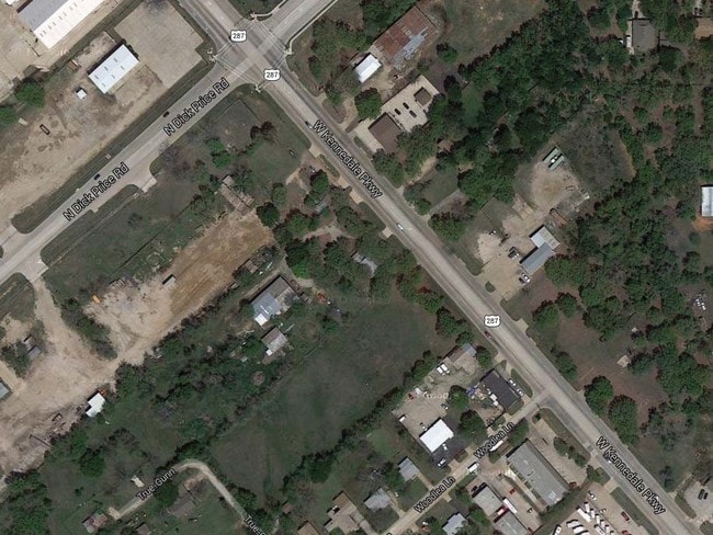
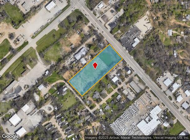
521 W Kennedale Pkwy, Kennedale, TX 76060

NEARBY LISTINGS FOR SALE OR LEASE
Property Detail
521 W Kennedale Pkwy
Dallas-Fort Worth-Arlington, TX
Woodlea Acres
04479793
WOODLEA ACRES ADDITION BLOCK 2 LOT 9
Residentialacreage
Tarrant
X
Texas
48439C0340K
9
2024
2.73 AC
2025
Southeast Ft Worth
111405
Dallas/Ft Worth
DEMOGRAPHICS near 521 W Kennedale Pkwy
1 Mile
3 Mile
5 Mile
2024 Total Population
4,645
66,999
177,102
2029 Population
4,932
70,838
186,774
Pop Growth 2024-2029
+ 6.18%
+ 5.73%
+ 5.46%
Average Age
39
38
38
2024 Total Households
1,590
23,756
59,962
HH Growth 2024-2029
+ 6.23%
+ 5.75%
+ 5.48%
Median Household Inc
$90,012
$65,564
$66,745
Avg Household Size
2.90
2.80
2.90
2024 Avg HH Vehicles
2.00
2.00
2.00
Median Home Value
$325,650
$247,505
$242,264
Median Year Built
1988
1986
1983
Nearby Places
Map Layers
Map Styles
 Street
 Aerial
- Restaurants
- Banks
- Shops
- Fitness
- Groceries
PUBLIC TRANSPORTATION
AIRPORT
Dallas-Fort Worth International
DRIVE
WALK
Distance
Dallas-Fort Worth International
38 min
28.0 mi
Dallas Love Field
DRIVE
WALK
Distance
Dallas Love Field
48 min
36.7 mi
Freight Ports
Port of Shreveport
DRIVE
WALK
Distance
Port of Shreveport
240 min
223.5 mi
SALE & LEASE HISTORY
LISTING DATE
SALE/LEASE

Sep 12, 2018
For Sale
Sep 03, 2019
For Sale
Oct 15, 2018
For Sale
May 05, 2017
For Sale
Jul 11, 2019
For Sale
Nearby Properties
Address
Land Use
TOTAL SIZE
Lot Size
Zoning
Address
Land Use
TOTAL SIZE
Lot Size
Zoning
605,489 SF
35.12 AC
Address
Land Use
TOTAL SIZE
Lot Size
Zoning
181,611 SF
24.44 AC
Address
Land Use
TOTAL SIZE
Lot Size
Zoning
214,444 SF
17.45 AC
Address
Land Use
TOTAL SIZE
Lot Size
Zoning
167,643 SF
8.99 AC
Address
Land Use
TOTAL SIZE
Lot Size
Zoning
186,894 SF
10.85 AC
Address
Land Use
TOTAL SIZE
Lot Size
Zoning
169,347 SF
13.92 AC
Address
Land Use
TOTAL SIZE
Lot Size
Zoning
222,500 SF
13.86 AC
Address
Land Use
TOTAL SIZE
Lot Size
Zoning
169,837 SF
9.44 AC
Address
Land Use
TOTAL SIZE
Lot Size
Zoning
180,556 SF
11.78 AC
Address
Land Use
TOTAL SIZE
Lot Size
Zoning
147,822 SF
9.45 AC
Address
Land Use
TOTAL SIZE
Lot Size
Zoning
301,302 SF
0.46 AC
Address
Land Use
TOTAL SIZE
Lot Size
Zoning
193,290 SF
10.56 AC
Address
Land Use
TOTAL SIZE
Lot Size
Zoning
239,360 SF
17.55 AC
Address
Land Use
TOTAL SIZE
Lot Size
Zoning
159,030 SF
10.32 AC
Address
Land Use
TOTAL SIZE
Lot Size
Zoning
268,603 SF
12.45 AC
Address
Land Use
TOTAL SIZE
Lot Size
Zoning
238,119 SF
7.52 AC
Address
Land Use
TOTAL SIZE
Lot Size
Zoning
142,110 SF
7.40 AC
Address
Land Use
TOTAL SIZE
Lot Size
Zoning
119,741 SF
45 AC
Address
Land Use
TOTAL SIZE
Lot Size
Zoning
171,684 SF
8.12 AC
Address
Land Use
TOTAL SIZE
Lot Size
Zoning
4,886 SF
45.16 AC
Address
Land Use
TOTAL SIZE
Lot Size
Zoning
255,568 SF
14.79 AC
Address
Land Use
TOTAL SIZE
Lot Size
Zoning
4,888 SF
31.18 AC
Address
Land Use
TOTAL SIZE
Lot Size
Zoning
2,058 SF
37.92 AC
Address
Land Use
TOTAL SIZE
Lot Size
Zoning
246,423 SF
18.84 AC
Address
Land Use
TOTAL SIZE
Lot Size
Zoning
143,104 SF
7.75 AC
Address
Land Use
TOTAL SIZE
Lot Size
Zoning
189,323 SF
44.29 AC
Address
Land Use
TOTAL SIZE
Lot Size
Zoning
238,977 SF
58.29 AC
Address
Land Use
TOTAL SIZE
Lot Size
Zoning
3,078 SF
28.32 AC
Address
Land Use
TOTAL SIZE
Lot Size
Zoning
259,627 SF
18.87 AC
Address
Land Use
TOTAL SIZE
Lot Size
Zoning
101,030 SF
10.11 AC
The World's #1 Commercial Real Estate Marketplace
Connect with us
© 2025 CoStar Group
The information above has been obtained from sources believed reliable. While we do not doubt its accuracy we have not verified it and make no guarantee, warranty or representation about it. It is your responsibility to independently confirm its accuracy and completeness. Any projections, opinions, assumptions, or estimates used are for example only and do not represent the current or future performance of the property. The value of this transaction to you depends on tax and other factors which should be evaluated by your tax, financial, and legal advisors. You and your advisors should conduct a careful, independent investigation of the property to determine to your satisfaction the suitability of the property for your needs.