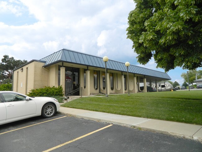
Property Record
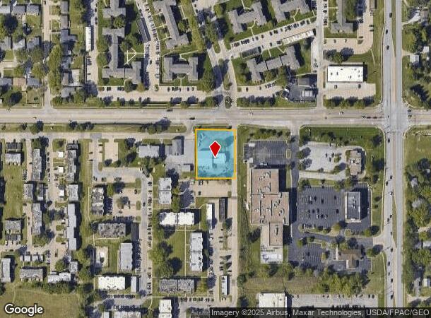
5210 S 86Th Plz, Omaha, NE 68127

NEARBY LISTINGS FOR SALE OR LEASE
Property Detail
5210 S 86Th Plz
2587-0010-01
Lands
Officebuilding
LANDS SEC-TWN-RGE 10-14-12 E 162 W 622.11 S 200 N 250 FT NE 1/4 NE 1/4
X
Douglas
31153C0060G
Nebraska
2024
0.74 AC
2025
South Central Omaha
007467
Omaha/Council Bluffs
3,516 SF
Omaha-Council Bluffs, NE-IA
DEMOGRAPHICS near 5210 S 86Th Plz
1 Mile
3 Mile
5 Mile
2024 Total Population
12,570
84,348
225,595
2029 Population
12,714
87,238
232,361
Pop Growth 2024-2029
+ 1.15%
+ 3.43%
+ 3.00%
Average Age
38
39
39
2024 Total Households
5,840
35,392
92,218
HH Growth 2024-2029
+ 1.25%
+ 3.37%
+ 3.00%
Median Household Inc
$53,419
$67,057
$69,128
Avg Household Size
2.10
2.30
2.40
2024 Avg HH Vehicles
2.00
2.00
2.00
Median Home Value
$182,759
$225,754
$215,970
Median Year Built
1975
1977
1972
Nearby Places
Map Layers
Map Styles
 Street
 Aerial
- Restaurants
- Banks
- Shops
- Fitness
- Groceries
PUBLIC TRANSPORTATION
COMMUTER RAIL
Omaha Amtrak Station (California Zephyr - Amtrak)
DRIVE
WALK
Distance
Omaha Amtrak Station (California Zephyr - Amtrak)
14 min
8.9 mi
Omaha Amtrak Station (California Zephyr - Amtrak)
DRIVE
WALK
Distance
Omaha Amtrak Station (California Zephyr - Amtrak)
15 min
9.0 mi
AIRPORT
Eppley Airfield
DRIVE
WALK
Distance
Eppley Airfield
23 min
12.9 mi
Freight Ports
Tulsa Port Of Catoosa
DRIVE
WALK
Distance
Tulsa Port Of Catoosa
467 min
420.4 mi
Nearby Properties
Address
Land Use
TOTAL SIZE
Lot Size
Zoning
Address
Land Use
TOTAL SIZE
Lot Size
Zoning
255,351 SF
0.79 AC
Address
Land Use
TOTAL SIZE
Lot Size
Zoning
326,069 SF
4.88 AC
Address
Land Use
TOTAL SIZE
Lot Size
Zoning
25,204 SF
2.34 AC
R4
Address
Land Use
TOTAL SIZE
Lot Size
Zoning
341,667 SF
24.15 AC
Address
Land Use
TOTAL SIZE
Lot Size
Zoning
370,890 SF
11.20 AC
CC
Address
Land Use
TOTAL SIZE
Lot Size
Zoning
503,886 SF
25.40 AC
Address
Land Use
TOTAL SIZE
Lot Size
Zoning
317,277 SF
20.12 AC
Address
Land Use
TOTAL SIZE
Lot Size
Zoning
389,488 SF
4.30 AC
Address
Land Use
TOTAL SIZE
Lot Size
Zoning
145,190 SF
5.45 AC
Address
Land Use
TOTAL SIZE
Lot Size
Zoning
28,913 SF
2.04 AC
Address
Land Use
TOTAL SIZE
Lot Size
Zoning
120,078 SF
1.24 AC
MU
Address
Land Use
TOTAL SIZE
Lot Size
Zoning
897,738 SF
52.16 AC
Address
Land Use
TOTAL SIZE
Lot Size
Zoning
23,890 SF
14.34 AC
I2
Address
Land Use
TOTAL SIZE
Lot Size
Zoning
354,299 SF
22.85 AC
R6
Address
Land Use
TOTAL SIZE
Lot Size
Zoning
114,936 SF
1.93 AC
Address
Land Use
TOTAL SIZE
Lot Size
Zoning
294,672 SF
15.06 AC
Address
Land Use
TOTAL SIZE
Lot Size
Zoning
129,910 SF
0.92 AC
Address
Land Use
TOTAL SIZE
Lot Size
Zoning
646,213 SF
37.22 AC
Address
Land Use
TOTAL SIZE
Lot Size
Zoning
354,615 SF
18.13 AC
R6
Address
Land Use
TOTAL SIZE
Lot Size
Zoning
13,930 SF
1.04 AC
Address
Land Use
TOTAL SIZE
Lot Size
Zoning
199,152 SF
13.44 AC
R6
Address
Land Use
TOTAL SIZE
Lot Size
Zoning
271,344 SF
9.78 AC
Address
Land Use
TOTAL SIZE
Lot Size
Zoning
271,404 SF
17.51 AC
Address
Land Use
TOTAL SIZE
Lot Size
Zoning
309,162 SF
15.54 AC
Address
Land Use
TOTAL SIZE
Lot Size
Zoning
112,933 SF
1.23 AC
MU
Address
Land Use
TOTAL SIZE
Lot Size
Zoning
258,637 SF
24.30 AC
Address
Land Use
TOTAL SIZE
Lot Size
Zoning
97,617 SF
49.05 AC
Address
Land Use
TOTAL SIZE
Lot Size
Zoning
2,610 SF
9.96 AC
Address
Land Use
TOTAL SIZE
Lot Size
Zoning
286,445 SF
16.18 AC
R6
Address
Land Use
TOTAL SIZE
Lot Size
Zoning
407,410 SF
4.03 AC
The World's #1 Commercial Real Estate Marketplace
Connect with us
© 2025 CoStar Group
The information above has been obtained from sources believed reliable. While we do not doubt its accuracy we have not verified it and make no guarantee, warranty or representation about it. It is your responsibility to independently confirm its accuracy and completeness. Any projections, opinions, assumptions, or estimates used are for example only and do not represent the current or future performance of the property. The value of this transaction to you depends on tax and other factors which should be evaluated by your tax, financial, and legal advisors. You and your advisors should conduct a careful, independent investigation of the property to determine to your satisfaction the suitability of the property for your needs.