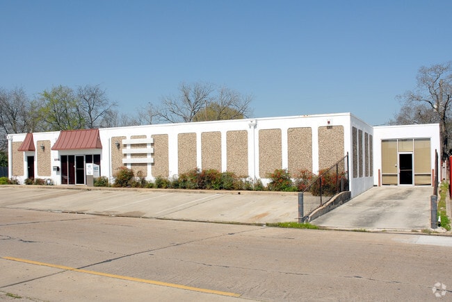
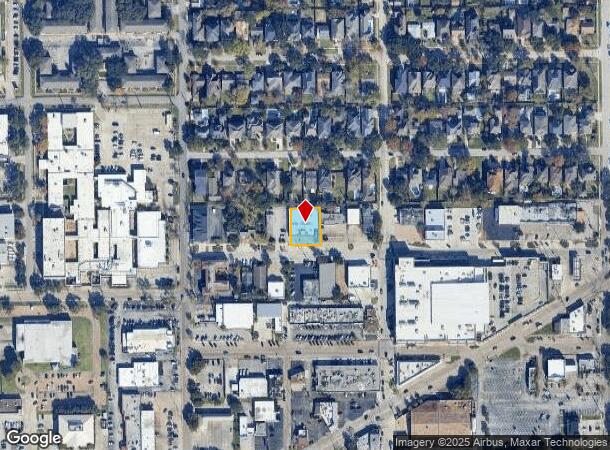
Property Record
5210 Spruce St, Bellaire, TX 77401

NEARBY LISTINGS FOR SALE OR LEASE
Property Detail
5210 Spruce St
Houston-The Woodlands-Sugar Land, TX
Abandon Alley Bellaire
0070560440019
LTS 19 & 20 BLK 44 & ADJ S 5 FT OF ABANDON ALLEY BELLAIRE
Warehouse
Harris
AE
Texas
48201C0855L
19,20
2024
0.30 AC
2025
Hwy 59/Hwy 90 (Alt)
421000
Houston
8,430 SF
DEMOGRAPHICS near 5210 Spruce St
1 Mile
3 Mile
5 Mile
2024 Total Population
25,008
245,493
556,346
2029 Population
25,805
253,263
573,483
Pop Growth 2024-2029
+ 3.19%
+ 3.17%
+ 3.08%
Average Age
36
36
37
2024 Total Households
9,124
104,251
241,513
HH Growth 2024-2029
+ 3.20%
+ 3.27%
+ 3.15%
Median Household Inc
$44,988
$64,857
$60,293
Avg Household Size
2.70
2.30
2.20
2024 Avg HH Vehicles
2.00
2.00
1.00
Median Home Value
$801,337
$556,093
$457,518
Median Year Built
1981
1982
1982
Nearby Places
Map Layers
Map Styles
 Street
 Aerial
- Restaurants
- Banks
- Shops
- Fitness
- Groceries
PUBLIC TRANSPORTATION
COMMUTER RAIL
Houston (Sunset Limited - Amtrak)
DRIVE
WALK
Distance
Houston (Sunset Limited - Amtrak)
16 min
9.4 mi
AIRPORT
William P Hobby
DRIVE
WALK
Distance
William P Hobby
31 min
17.5 mi
George Bush Intcntl/Houston
DRIVE
WALK
Distance
George Bush Intcntl/Houston
37 min
28.6 mi
Freight Ports
Port of Houston
DRIVE
WALK
Distance
Port of Houston
27 min
17.8 mi
Nearby Properties
Address
Land Use
TOTAL SIZE
Lot Size
Zoning
Address
Land Use
TOTAL SIZE
Lot Size
Zoning
576,253 SF
5.91 AC
Address
Land Use
TOTAL SIZE
Lot Size
Zoning
716,631 SF
7.04 AC
Address
Land Use
TOTAL SIZE
Lot Size
Zoning
2,626,393 SF
6.70 AC
Address
Land Use
TOTAL SIZE
Lot Size
Zoning
1,880,742 SF
20.77 AC
Address
Land Use
TOTAL SIZE
Lot Size
Zoning
329,832 SF
1.75 AC
Address
Land Use
TOTAL SIZE
Lot Size
Zoning
1,062,592 SF
7.41 AC
Address
Land Use
TOTAL SIZE
Lot Size
Zoning
1,009,859 SF
28.73 AC
Address
Land Use
TOTAL SIZE
Lot Size
Zoning
771,702 SF
2.51 AC
Address
Land Use
TOTAL SIZE
Lot Size
Zoning
576,200 SF
2.65 AC
Address
Land Use
TOTAL SIZE
Lot Size
Zoning
777,791 SF
47.90 AC
Address
Land Use
TOTAL SIZE
Lot Size
Zoning
612,663 SF
7 AC
Address
Land Use
TOTAL SIZE
Lot Size
Zoning
549,506 SF
2.05 AC
Address
Land Use
TOTAL SIZE
Lot Size
Zoning
392,218 SF
1.21 AC
Address
Land Use
TOTAL SIZE
Lot Size
Zoning
616,387 SF
2.58 AC
Address
Land Use
TOTAL SIZE
Lot Size
Zoning
305,760 SF
2.22 AC
Address
Land Use
TOTAL SIZE
Lot Size
Zoning
1,819,963 SF
5.30 AC
Address
Land Use
TOTAL SIZE
Lot Size
Zoning
782,092 SF
8.87 AC
Address
Land Use
TOTAL SIZE
Lot Size
Zoning
214,297 SF
15.23 AC
Address
Land Use
TOTAL SIZE
Lot Size
Zoning
1,202,191 SF
39.08 AC
Address
Land Use
TOTAL SIZE
Lot Size
Zoning
840,388 SF
0.91 AC
Address
Land Use
TOTAL SIZE
Lot Size
Zoning
1,279,489 SF
2.83 AC
Address
Land Use
TOTAL SIZE
Lot Size
Zoning
338,285 SF
4.60 AC
Address
Land Use
TOTAL SIZE
Lot Size
Zoning
495,834 SF
1.49 AC
Address
Land Use
TOTAL SIZE
Lot Size
Zoning
1,098,342 SF
8.81 AC
Address
Land Use
TOTAL SIZE
Lot Size
Zoning
777,850 SF
6.48 AC
Address
Land Use
TOTAL SIZE
Lot Size
Zoning
216,178 SF
1.28 AC
Address
Land Use
TOTAL SIZE
Lot Size
Zoning
128,404 SF
2.88 AC
Address
Land Use
TOTAL SIZE
Lot Size
Zoning
323,456 SF
3.91 AC
Address
Land Use
TOTAL SIZE
Lot Size
Zoning
760,932 SF
14.37 AC
Address
Land Use
TOTAL SIZE
Lot Size
Zoning
133,258 SF
11.56 AC
The World's #1 Commercial Real Estate Marketplace
Connect with us
© 2025 CoStar Group
The information above has been obtained from sources believed reliable. While we do not doubt its accuracy we have not verified it and make no guarantee, warranty or representation about it. It is your responsibility to independently confirm its accuracy and completeness. Any projections, opinions, assumptions, or estimates used are for example only and do not represent the current or future performance of the property. The value of this transaction to you depends on tax and other factors which should be evaluated by your tax, financial, and legal advisors. You and your advisors should conduct a careful, independent investigation of the property to determine to your satisfaction the suitability of the property for your needs.