Property Record
5212 Willis Rd, Theodore, AL 36582
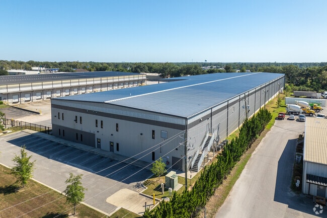

Property Detail
5212 Willis Rd
Mobile, AL
LOT 2 CORRECTION PLAT OF RAMS HEAD ADDN TO TILLMANS CORNER UNIT ONE MBK 97/8 #SEC 28 T5S R2W #MP33 08 28 4 000
33-08-28-4-000-027.002
MOBILE
Warehouse
Alabama
B and X Area of moderate flood hazard, usually the area between the limits of the 100-year and 500-year floods.
2
2025
3.05 AC
2025
Outlying Mobile County
007101
Mobile
84,497 SF
NEARBY LISTINGS FOR SALE OR LEASE
DEMOGRAPHICS near 5212 Willis Rd
1 mile
3 mile
5 mile
2025 Total Population
3,086
22,986
60,428
2030 Population
3,036
22,825
59,675
Pop Growth 2025-2030
(1.62%)
(0.70%)
(1.25%)
Average Age
39
40
41
2025 Total Households
1,268
9,020
24,198
HH Growth 2025-2030
(1.66%)
(0.74%)
(1.28%)
Median Household Inc
$51,452
$55,377
$63,546
Avg Household Size
2.40
2.50
2.40
2025 Avg HH Vehicles
2.00
2.00
2.00
Median Home Value
$149,107
$167,044
$200,292
Median Year Built
1978
1982
1984
Nearby Places
Map Layers
Map Styles
 Street
 Aerial
Layers
 Traffic
 Biking
Places
Listings with unknown addresses are not visible on the map
- Restaurants
- Banks
- Shops
- Fitness
- Groceries
PUBLIC TRANSPORTATION
AIRPORT
Mobile International
Drive
Walk
Distance
Mobile International
14 min
9.0 mi
Mobile Regional
Drive
Walk
Distance
Mobile Regional
29 min
13.5 mi
Freight Ports
Port of Mobile
Drive
Walk
Distance
Port of Mobile
17 min
12.4 mi
SALE & LEASE HISTORY
LISTING DATE
SALE/LEASE

Mar 01, 2024
For Lease
Nearby Properties
Address
Land Use
TOTAL SIZE
Lot Size
Zoning
Address
Land Use
TOTAL SIZE
Lot Size
Zoning
85,823 SF
13.26 AC
Address
Land Use
TOTAL SIZE
Lot Size
Zoning
362,880 SF
32.55 AC
Address
Land Use
TOTAL SIZE
Lot Size
Zoning
117,000 SF
Address
Land Use
TOTAL SIZE
Lot Size
Zoning
202,866 SF
8.52 AC
Address
Land Use
TOTAL SIZE
Lot Size
Zoning
24,255 SF
9.15 AC
Address
Land Use
TOTAL SIZE
Lot Size
Zoning
155,320 SF
21.48 AC
Address
Land Use
TOTAL SIZE
Lot Size
Zoning
342,598 SF
11.94 AC
Address
Land Use
TOTAL SIZE
Lot Size
Zoning
78,750 SF
27.51 AC
Address
Land Use
TOTAL SIZE
Lot Size
Zoning
167,968 SF
12.40 AC
Address
Land Use
TOTAL SIZE
Lot Size
Zoning
26,933 SF
82.37 AC
Address
Land Use
TOTAL SIZE
Lot Size
Zoning
86,168 SF
42 AC
Address
Land Use
TOTAL SIZE
Lot Size
Zoning
234,275 SF
40.29 AC
Address
Land Use
TOTAL SIZE
Lot Size
Zoning
204,868 SF
22.14 AC
Address
Land Use
TOTAL SIZE
Lot Size
Zoning
27,580 SF
4.69 AC
Address
Land Use
TOTAL SIZE
Lot Size
Zoning
132,400 SF
23 AC
Address
Land Use
TOTAL SIZE
Lot Size
Zoning
15,476 SF
10.44 AC
Address
Land Use
TOTAL SIZE
Lot Size
Zoning
78,750 SF
24 AC
Address
Land Use
TOTAL SIZE
Lot Size
Zoning
193,452 SF
17.61 AC
Address
Land Use
TOTAL SIZE
Lot Size
Zoning
20,000 SF
28.80 AC
Address
Land Use
TOTAL SIZE
Lot Size
Zoning
139,097 SF
11.64 AC
Address
Land Use
TOTAL SIZE
Lot Size
Zoning
66,382 SF
1.71 AC
Address
Land Use
TOTAL SIZE
Lot Size
Zoning
99,076 SF
25 AC
Address
Land Use
TOTAL SIZE
Lot Size
Zoning
12,071 SF
6.87 AC
Address
Land Use
TOTAL SIZE
Lot Size
Zoning
86,820 SF
4.50 AC
Address
Land Use
TOTAL SIZE
Lot Size
Zoning
94,116 SF
7.11 AC
Address
Land Use
TOTAL SIZE
Lot Size
Zoning
185.25 AC
Address
Land Use
TOTAL SIZE
Lot Size
Zoning
396.69 AC
Address
Land Use
TOTAL SIZE
Lot Size
Zoning
21,143 SF
7.03 AC
Address
Land Use
TOTAL SIZE
Lot Size
Zoning
76,560 SF
27.88 AC
Address
Land Use
TOTAL SIZE
Lot Size
Zoning
60,630 SF
6.70 AC
The World's #1 Commercial Real Estate Marketplace
Connect with us
© 2026 CoStar Group
The information above has been obtained from sources believed reliable. While we do not doubt its accuracy we have not verified it and make no guarantee, warranty or representation about it. It is your responsibility to independently confirm its accuracy and completeness. Any projections, opinions, assumptions, or estimates used are for example only and do not represent the current or future performance of the property. The value of this transaction to you depends on tax and other factors which should be evaluated by your tax, financial, and legal advisors. You and your advisors should conduct a careful, independent investigation of the property to determine to your satisfaction the suitability of the property for your needs.