Property Record
5214 Burleson Rd, Austin, TX 78744
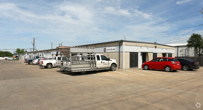

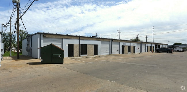
Property Detail
5214 Burleson Rd
Austin-Round Rock-San Marcos, TX
4.9174AC OF LOT 19-21 ACI INDUSTRIAL PARK IV
551942
Travis
Warehouse
Texas
B and X Area of moderate flood hazard, usually the area between the limits of the 100-year and 500-year floods.
19-21
2025
4.92 AC
2025
Southeast
002447
Austin
94,875 SF
NEARBY LISTINGS FOR SALE OR LEASE
DEMOGRAPHICS near 5214 Burleson Rd
1 mile
3 mile
5 mile
2025 Total Population
6,499
120,263
285,638
2030 Population
6,830
126,775
302,215
Pop Growth 2025-2030
+ 5.09%
+ 5.41%
+ 5.80%
Average Age
35
35
36
2025 Total Households
2,778
50,880
129,828
HH Growth 2025-2030
+ 5.33%
+ 6.14%
+ 6.51%
Median Household Inc
$63,330
$72,789
$90,036
Avg Household Size
2.20
2.20
2.10
2025 Avg HH Vehicles
2.00
2.00
2.00
Median Home Value
$445,535
$463,705
$586,959
Median Year Built
1994
1997
2002
Nearby Places
Map Layers
Map Styles
 Street
 Aerial
Layers
 Traffic
 Biking
Places
Listings with unknown addresses are not visible on the map
- Restaurants
- Banks
- Shops
- Fitness
- Groceries
PUBLIC TRANSPORTATION
COMMUTER RAIL
Drive
Walk
Distance
13 min
6.2 mi
AIRPORT
Austin-Bergstrom International
Drive
Walk
Distance
Austin-Bergstrom International
15 min
6.3 mi
SALE & LEASE HISTORY
LISTING DATE
SALE/LEASE

Mar 29, 2017
For Lease
Nearby Properties
Address
Land Use
TOTAL SIZE
Lot Size
Zoning
Address
Land Use
TOTAL SIZE
Lot Size
Zoning
9,768 SF
386.80 AC
Address
Land Use
TOTAL SIZE
Lot Size
Zoning
999,200 SF
25 AC
Address
Land Use
TOTAL SIZE
Lot Size
Zoning
8,213 SF
36.95 AC
Address
Land Use
TOTAL SIZE
Lot Size
Zoning
356,147 SF
10.48 AC
Address
Land Use
TOTAL SIZE
Lot Size
Zoning
492,715 SF
9.22 AC
Address
Land Use
TOTAL SIZE
Lot Size
Zoning
456,650 SF
15 AC
Address
Land Use
TOTAL SIZE
Lot Size
Zoning
307,610 SF
8.95 AC
Address
Land Use
TOTAL SIZE
Lot Size
Zoning
454,740 SF
27.77 AC
Address
Land Use
TOTAL SIZE
Lot Size
Zoning
387,267 SF
3.25 AC
Address
Land Use
TOTAL SIZE
Lot Size
Zoning
290,643 SF
13.59 AC
Address
Land Use
TOTAL SIZE
Lot Size
Zoning
539,533 SF
26.50 AC
Address
Land Use
TOTAL SIZE
Lot Size
Zoning
558,324 SF
45.12 AC
Address
Land Use
TOTAL SIZE
Lot Size
Zoning
4,944 SF
25.09 AC
Address
Land Use
TOTAL SIZE
Lot Size
Zoning
386,952 SF
6.77 AC
Address
Land Use
TOTAL SIZE
Lot Size
Zoning
255,483 SF
35 AC
Address
Land Use
TOTAL SIZE
Lot Size
Zoning
335,913 SF
13.83 AC
Address
Land Use
TOTAL SIZE
Lot Size
Zoning
390,384 SF
34.08 AC
Address
Land Use
TOTAL SIZE
Lot Size
Zoning
272,084 SF
3.87 AC
Address
Land Use
TOTAL SIZE
Lot Size
Zoning
256,182 SF
3.63 AC
Address
Land Use
TOTAL SIZE
Lot Size
Zoning
281,588 SF
6.29 AC
Address
Land Use
TOTAL SIZE
Lot Size
Zoning
266,871 SF
9.13 AC
Address
Land Use
TOTAL SIZE
Lot Size
Zoning
372,125 SF
26.22 AC
Address
Land Use
TOTAL SIZE
Lot Size
Zoning
264,897 SF
2.54 AC
Address
Land Use
TOTAL SIZE
Lot Size
Zoning
9.80 AC
Address
Land Use
TOTAL SIZE
Lot Size
Zoning
279,539 SF
3.99 AC
Address
Land Use
TOTAL SIZE
Lot Size
Zoning
297,552 SF
15.93 AC
Address
Land Use
TOTAL SIZE
Lot Size
Zoning
193,788 SF
107.16 AC
Address
Land Use
TOTAL SIZE
Lot Size
Zoning
359,144 SF
Address
Land Use
TOTAL SIZE
Lot Size
Zoning
210,375 SF
3.36 AC
Address
Land Use
TOTAL SIZE
Lot Size
Zoning
278,730 SF
19.78 AC
The World's #1 Commercial Real Estate Marketplace
Connect with us
© 2026 CoStar Group
The information above has been obtained from sources believed reliable. While we do not doubt its accuracy we have not verified it and make no guarantee, warranty or representation about it. It is your responsibility to independently confirm its accuracy and completeness. Any projections, opinions, assumptions, or estimates used are for example only and do not represent the current or future performance of the property. The value of this transaction to you depends on tax and other factors which should be evaluated by your tax, financial, and legal advisors. You and your advisors should conduct a careful, independent investigation of the property to determine to your satisfaction the suitability of the property for your needs.