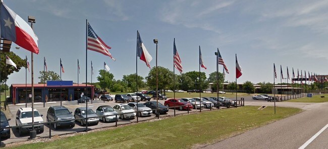
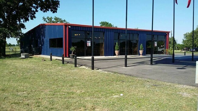
Property Record
52186 Highway 290, Hempstead, TX 77445

Property Detail
52186 Highway 290
Houston-Pasadena-The Woodlands, TX
S582880 MARSHALL SUB LOT TRACT 1 ACRES 4.877
207738
Waller
Commercialnec
Texas
B and X Area of moderate flood hazard, usually the area between the limits of the 100-year and 500-year floods.
1
2023
4.88 AC
2025
Waller County
680502
Houston
11,946 SF
NEARBY LISTINGS FOR SALE OR LEASE
DEMOGRAPHICS near 52186 Highway 290
1 mile
3 mile
5 mile
2025 Total Population
199
4,380
7,750
2030 Population
222
4,837
8,546
Pop Growth 2025-2030
+ 11.56%
+ 10.43%
+ 10.27%
Average Age
39
38
38
2025 Total Households
69
1,554
2,818
HH Growth 2025-2030
+ 10.14%
+ 9.97%
+ 9.94%
Median Household Inc
$66,428
$58,078
$58,396
Avg Household Size
2.80
2.80
2.70
2025 Avg HH Vehicles
2.00
2.00
2.00
Median Home Value
$235,000
$215,957
$232,564
Median Year Built
1987
1987
1986
Nearby Places
Map Layers
Map Styles
 Street
 Aerial
Layers
 Traffic
 Biking
Places
Listings with unknown addresses are not visible on the map
- Restaurants
- Banks
- Shops
- Fitness
- Groceries
PUBLIC TRANSPORTATION
AIRPORT
Easterwood Field
Drive
Walk
Distance
Easterwood Field
62 min
48.5 mi
Freight Ports
Port of Houston
Drive
Walk
Distance
Port of Houston
80 min
63.6 mi
SALE & LEASE HISTORY
LISTING DATE
SALE/LEASE

Sep 25, 2016
For Lease
Sep 24, 2016
For Sale
Nov 08, 2021
For Sale
Jun 17, 2019
For Sale
Jul 02, 2020
For Lease
Nearby Properties
Address
Land Use
TOTAL SIZE
Lot Size
Zoning
Address
Land Use
TOTAL SIZE
Lot Size
Zoning
153,346 SF
8.52 AC
Address
Land Use
TOTAL SIZE
Lot Size
Zoning
52,080 SF
1 AC
Address
Land Use
TOTAL SIZE
Lot Size
Zoning
672 SF
136.86 AC
Address
Land Use
TOTAL SIZE
Lot Size
Zoning
169,905 SF
33.06 AC
Address
Land Use
TOTAL SIZE
Lot Size
Zoning
40,382 SF
145.93 AC
Address
Land Use
TOTAL SIZE
Lot Size
Zoning
5,120 SF
114.96 AC
Address
Land Use
TOTAL SIZE
Lot Size
Zoning
100,861 SF
28.29 AC
Address
Land Use
TOTAL SIZE
Lot Size
Zoning
77,952 SF
10.47 AC
Address
Land Use
TOTAL SIZE
Lot Size
Zoning
31,193 SF
12.04 AC
Address
Land Use
TOTAL SIZE
Lot Size
Zoning
30,255 SF
19.61 AC
Address
Land Use
TOTAL SIZE
Lot Size
Zoning
19,840 SF
1.44 AC
Address
Land Use
TOTAL SIZE
Lot Size
Zoning
6,855 SF
5 AC
Address
Land Use
TOTAL SIZE
Lot Size
Zoning
0.72 AC
Address
Land Use
TOTAL SIZE
Lot Size
Zoning
8,326 SF
547.89 AC
Address
Land Use
TOTAL SIZE
Lot Size
Zoning
10,080 SF
5.34 AC
Address
Land Use
TOTAL SIZE
Lot Size
Zoning
27,966 SF
9.38 AC
Address
Land Use
TOTAL SIZE
Lot Size
Zoning
10,855 SF
1.45 AC
Address
Land Use
TOTAL SIZE
Lot Size
Zoning
12,532 SF
102.34 AC
Address
Land Use
TOTAL SIZE
Lot Size
Zoning
6,788 SF
57.74 AC
Address
Land Use
TOTAL SIZE
Lot Size
Zoning
46,384 SF
9.86 AC
Address
Land Use
TOTAL SIZE
Lot Size
Zoning
17,600 SF
5.29 AC
Address
Land Use
TOTAL SIZE
Lot Size
Zoning
13.71 AC
Address
Land Use
TOTAL SIZE
Lot Size
Zoning
4,866 SF
75.48 AC
Address
Land Use
TOTAL SIZE
Lot Size
Zoning
1.55 AC
Address
Land Use
TOTAL SIZE
Lot Size
Zoning
4,535 SF
4 AC
Address
Land Use
TOTAL SIZE
Lot Size
Zoning
20,299 SF
1.44 AC
Address
Land Use
TOTAL SIZE
Lot Size
Zoning
8,076 SF
1.91 AC
Address
Land Use
TOTAL SIZE
Lot Size
Zoning
16,456 SF
160.07 AC
Address
Land Use
TOTAL SIZE
Lot Size
Zoning
5,238 SF
18.88 AC
The World's #1 Commercial Real Estate Marketplace
Connect with us
© 2026 CoStar Group
The information above has been obtained from sources believed reliable. While we do not doubt its accuracy we have not verified it and make no guarantee, warranty or representation about it. It is your responsibility to independently confirm its accuracy and completeness. Any projections, opinions, assumptions, or estimates used are for example only and do not represent the current or future performance of the property. The value of this transaction to you depends on tax and other factors which should be evaluated by your tax, financial, and legal advisors. You and your advisors should conduct a careful, independent investigation of the property to determine to your satisfaction the suitability of the property for your needs.