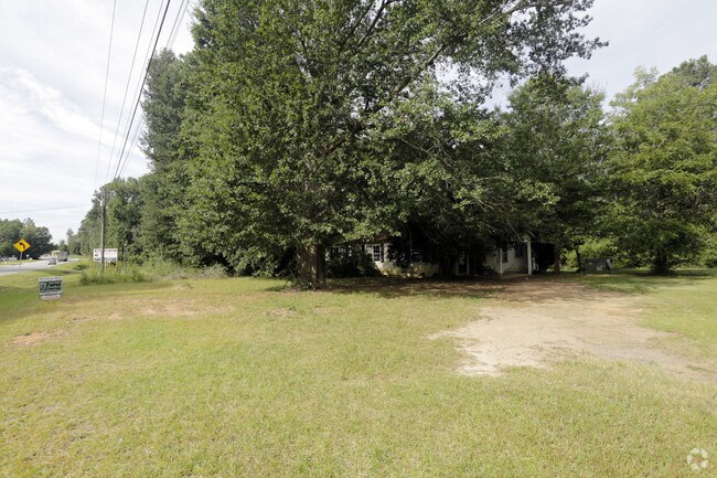
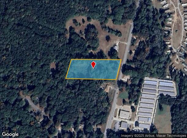
Property Record
5219 Highway 20 S, Covington, GA 30016

NEARBY LISTINGS FOR SALE OR LEASE
Property Detail
5219 Highway 20 S
0007A00000016000
Hwy 20
Residentialacreage
3AC HWY 20
X
Newton
13247C0167D
Georgia
2025
3 AC
2025
Newton County
100903
Atlanta
1,682 SF
Atlanta-Sandy Springs-Roswell, GA
DEMOGRAPHICS near 5219 Highway 20 S
1 Mile
3 Mile
5 Mile
2024 Total Population
3,118
25,839
67,190
2029 Population
3,303
27,531
72,036
Pop Growth 2024-2029
+ 5.93%
+ 6.55%
+ 7.21%
Average Age
40
40
39
2024 Total Households
1,112
8,982
23,315
HH Growth 2024-2029
+ 6.12%
+ 6.62%
+ 7.35%
Median Household Inc
$73,033
$81,128
$75,098
Avg Household Size
2.80
2.80
2.80
2024 Avg HH Vehicles
2.00
2.00
2.00
Median Home Value
$163,270
$214,083
$215,793
Median Year Built
1984
1992
1994
Nearby Places
Map Layers
Map Styles
 Street
 Aerial
- Restaurants
- Banks
- Shops
- Fitness
- Groceries
PUBLIC TRANSPORTATION
AIRPORT
Hartsfield - Jackson Atlanta International
DRIVE
WALK
Distance
Hartsfield - Jackson Atlanta International
48 min
32.1 mi
Freight Ports
Georgia Ports - Savannah
DRIVE
WALK
Distance
Georgia Ports - Savannah
265 min
232.4 mi
SALE & LEASE HISTORY
LISTING DATE
SALE/LEASE

Sep 14, 2017
For Sale
Nearby Properties
Address
Land Use
TOTAL SIZE
Lot Size
Zoning
Address
Land Use
TOTAL SIZE
Lot Size
Zoning
65,360 SF
75.51 AC
E6
Address
Land Use
TOTAL SIZE
Lot Size
Zoning
18,648 SF
2.48 AC
C1
Address
Land Use
TOTAL SIZE
Lot Size
Zoning
81,591 SF
12.80 AC
C2
Address
Land Use
TOTAL SIZE
Lot Size
Zoning
63,328 SF
10.67 AC
C2
Address
Land Use
TOTAL SIZE
Lot Size
Zoning
81,730 SF
17.98 AC
C1
Address
Land Use
TOTAL SIZE
Lot Size
Zoning
38,250 SF
26.56 AC
AR
Address
Land Use
TOTAL SIZE
Lot Size
Zoning
65,360 SF
30.63 AC
E6
Address
Land Use
TOTAL SIZE
Lot Size
Zoning
50,096 SF
4.19 AC
C1
Address
Land Use
TOTAL SIZE
Lot Size
Zoning
9,779 SF
1.41 AC
C1
Address
Land Use
TOTAL SIZE
Lot Size
Zoning
64,800 SF
16.19 AC
AR
Address
Land Use
TOTAL SIZE
Lot Size
Zoning
18,751 SF
4.14 AC
C2/OI
Address
Land Use
TOTAL SIZE
Lot Size
Zoning
19,363 SF
4 AC
AR
Address
Land Use
TOTAL SIZE
Lot Size
Zoning
17,558 SF
5.08 AC
AR/C1
Address
Land Use
TOTAL SIZE
Lot Size
Zoning
24,750 SF
6 AC
R1
Address
Land Use
TOTAL SIZE
Lot Size
Zoning
13,182 SF
1.89 AC
CN
Address
Land Use
TOTAL SIZE
Lot Size
Zoning
5,880 SF
0.54 AC
C1
Address
Land Use
TOTAL SIZE
Lot Size
Zoning
8,964 SF
0.86 AC
C2
Address
Land Use
TOTAL SIZE
Lot Size
Zoning
3,500 SF
0.85 AC
C1
Address
Land Use
TOTAL SIZE
Lot Size
Zoning
12,600 SF
1.33 AC
C2
Address
Land Use
TOTAL SIZE
Lot Size
Zoning
11,876 SF
115.43 AC
R1
Address
Land Use
TOTAL SIZE
Lot Size
Zoning
12,934 SF
2.37 AC
E3
Address
Land Use
TOTAL SIZE
Lot Size
Zoning
12,546 SF
3.44 AC
OI/C
Address
Land Use
TOTAL SIZE
Lot Size
Zoning
1,754 SF
1.14 AC
C2
Address
Land Use
TOTAL SIZE
Lot Size
Zoning
2,065 SF
15 AC
E2
Address
Land Use
TOTAL SIZE
Lot Size
Zoning
2,128 SF
10 AC
AR
Address
Land Use
TOTAL SIZE
Lot Size
Zoning
6,161 SF
3.68 AC
C1
Address
Land Use
TOTAL SIZE
Lot Size
Zoning
16,620 SF
10.86 AC
AR
Address
Land Use
TOTAL SIZE
Lot Size
Zoning
26,000 SF
3.09 AC
C1
Address
Land Use
TOTAL SIZE
Lot Size
Zoning
359.47 AC
A
Address
Land Use
TOTAL SIZE
Lot Size
Zoning
3,780 SF
78.28 AC
E2
The World's #1 Commercial Real Estate Marketplace
Connect with us
© 2025 CoStar Group
The information above has been obtained from sources believed reliable. While we do not doubt its accuracy we have not verified it and make no guarantee, warranty or representation about it. It is your responsibility to independently confirm its accuracy and completeness. Any projections, opinions, assumptions, or estimates used are for example only and do not represent the current or future performance of the property. The value of this transaction to you depends on tax and other factors which should be evaluated by your tax, financial, and legal advisors. You and your advisors should conduct a careful, independent investigation of the property to determine to your satisfaction the suitability of the property for your needs.