Property Record
5219 Maple Ave, Dallas, TX 75235
NEARBY LISTINGS FOR SALE OR LEASE
Property Detail
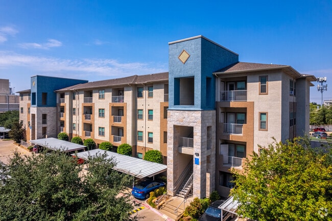
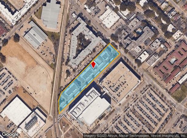
5219 Maple Ave
Dallas-Fort Worth-Arlington, TX
Maple Gardens
002318000A0020000
MAPLE GARDENS BLK A/2318 LT 2 ACS 2.878 INT202200095912 DD04052022 CO-DC 2318 00A 00200 6DA2318 00A
Apartment
Dallas
X
Texas
48113C0330J
2
2024
2.88 AC
2025
Medical District
000401
Dallas/Ft Worth
133,350 SF
DEMOGRAPHICS near 5219 Maple Ave
1 Mile
3 Mile
5 Mile
2024 Total Population
23,735
151,324
370,128
2029 Population
24,183
152,999
373,484
Pop Growth 2024-2029
+ 1.89%
+ 1.11%
+ 0.91%
Average Age
36
37
37
2024 Total Households
12,636
81,352
175,826
HH Growth 2024-2029
+ 1.56%
+ 1.07%
+ 1.07%
Median Household Inc
$57,450
$80,377
$73,695
Avg Household Size
1.80
1.80
2.00
2024 Avg HH Vehicles
1.00
1.00
2.00
Median Home Value
$309,012
$467,591
$486,555
Median Year Built
2003
2002
1992
Nearby Places
Map Layers
Map Styles
 Street
 Aerial
- Restaurants
- Banks
- Shops
- Fitness
- Groceries
PUBLIC TRANSPORTATION
COMMUTER RAIL
DRIVE
WALK
Distance
3 min
18 min
0.9 mi
Medical/Market Center (Trinity Railway Express - Dallas Area Rapid Transit (DART))
DRIVE
WALK
Distance
Medical/Market Center (Trinity Railway Express - Dallas Area Rapid Transit (DART))
3 min
18 min
0.9 mi
AIRPORT
Dallas Love Field
DRIVE
WALK
Distance
Dallas Love Field
7 min
2.6 mi
Dallas-Fort Worth International
DRIVE
WALK
Distance
Dallas-Fort Worth International
25 min
18.1 mi
Nearby Properties
Address
Land Use
TOTAL SIZE
Lot Size
Zoning
Address
Land Use
TOTAL SIZE
Lot Size
Zoning
2,658,374 SF
37.70 AC
Z116
Address
Land Use
TOTAL SIZE
Lot Size
Zoning
2,476 SF
1,203.03 AC
Z116
Address
Land Use
TOTAL SIZE
Lot Size
Zoning
2,271,924 SF
Address
Land Use
TOTAL SIZE
Lot Size
Zoning
3,713,071 SF
9.94 AC
Address
Land Use
TOTAL SIZE
Lot Size
Zoning
4,407,366 SF
1,300 AC
IR
Address
Land Use
TOTAL SIZE
Lot Size
Zoning
815,000 SF
7.20 AC
Z239
Address
Land Use
TOTAL SIZE
Lot Size
Zoning
1,676,176 SF
2.18 AC
Z239
Address
Land Use
TOTAL SIZE
Lot Size
Zoning
906,730 SF
3.09 AC
Z239
Address
Land Use
TOTAL SIZE
Lot Size
Zoning
1,003,498 SF
22.15 AC
Z116
Address
Land Use
TOTAL SIZE
Lot Size
Zoning
299,170 SF
9.71 AC
Z97
Address
Land Use
TOTAL SIZE
Lot Size
Zoning
731,849 SF
3.13 AC
Z239
Address
Land Use
TOTAL SIZE
Lot Size
Zoning
1,896,570 SF
18.08 AC
Z151
Address
Land Use
TOTAL SIZE
Lot Size
Zoning
1,291,660 SF
2.56 AC
Z248
Address
Land Use
TOTAL SIZE
Lot Size
Zoning
1,026,046 SF
2.89 AC
Z248
Address
Land Use
TOTAL SIZE
Lot Size
Zoning
864,909 SF
3.02 AC
Z248
Address
Land Use
TOTAL SIZE
Lot Size
Zoning
504,533 SF
9.95 AC
Z151
Address
Land Use
TOTAL SIZE
Lot Size
Zoning
1,001,504 SF
3.37 AC
Z151
Address
Land Use
TOTAL SIZE
Lot Size
Zoning
1,424,070 SF
1.36 AC
Z21
Address
Land Use
TOTAL SIZE
Lot Size
Zoning
1,228,418 SF
24.51 AC
Z151
Address
Land Use
TOTAL SIZE
Lot Size
Zoning
724,979 SF
1.05 AC
Z239
Address
Land Use
TOTAL SIZE
Lot Size
Zoning
893,159 SF
1.17 AC
Z21
Address
Land Use
TOTAL SIZE
Lot Size
Zoning
1,980,000 SF
2.57 AC
Z21
Address
Land Use
TOTAL SIZE
Lot Size
Zoning
857,292 SF
1.47 AC
Z239
Address
Land Use
TOTAL SIZE
Lot Size
Zoning
602,716 SF
11.21 AC
Z239
Address
Land Use
TOTAL SIZE
Lot Size
Zoning
763,198 SF
3.01 AC
Z248
Address
Land Use
TOTAL SIZE
Lot Size
Zoning
638,046 SF
2.11 AC
Z239
Address
Land Use
TOTAL SIZE
Lot Size
Zoning
486,300 SF
1.55 AC
Z239
Address
Land Use
TOTAL SIZE
Lot Size
Zoning
906,627 SF
3.83 AC
Z239
Address
Land Use
TOTAL SIZE
Lot Size
Zoning
653,557 SF
0.68 AC
Z248
Address
Land Use
TOTAL SIZE
Lot Size
Zoning
676,930 SF
1.38 AC
Z248
The World's #1 Commercial Real Estate Marketplace
Connect with us
© 2025 CoStar Group
The information above has been obtained from sources believed reliable. While we do not doubt its accuracy we have not verified it and make no guarantee, warranty or representation about it. It is your responsibility to independently confirm its accuracy and completeness. Any projections, opinions, assumptions, or estimates used are for example only and do not represent the current or future performance of the property. The value of this transaction to you depends on tax and other factors which should be evaluated by your tax, financial, and legal advisors. You and your advisors should conduct a careful, independent investigation of the property to determine to your satisfaction the suitability of the property for your needs.