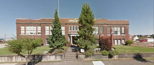
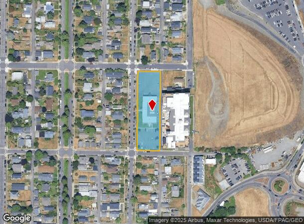
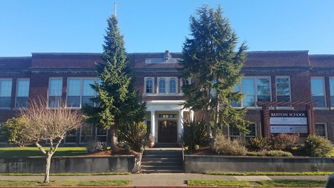
Property Record
5219 N Shirley St, Ruston, WA 98407
Current Lease Availabilities
NEARBY LISTINGS FOR SALE OR LEASE
-
-
View all Ruston listings for lease on LoopNet.com
Property Detail
5219 N Shirley St
Seattle-Tacoma-Bellevue, WA
Howard Heights 2Nd
465520-0190
SECTION 23 TOWNSHIP 21 RANGE 02 QUARTER 12 HOWARD HEIGHTS 2ND: HOWARD HEIGHTS 2ND L 1 THRU 14 B 4
Publicschool
Pierce
X
Washington
53033C1200G
1
2024
0.96 AC
2025
Tacoma Suburban
060300
Seattle/Puget Sound
10,500 SF
DEMOGRAPHICS near 5219 N Shirley St
1 Mile
3 Mile
5 Mile
2024 Total Population
8,320
44,503
137,702
2029 Population
8,676
45,869
142,475
Pop Growth 2024-2029
+ 4.28%
+ 3.07%
+ 3.47%
Average Age
45
43
42
2024 Total Households
3,637
19,122
60,123
HH Growth 2024-2029
+ 4.56%
+ 3.26%
+ 3.66%
Median Household Inc
$108,819
$102,943
$89,722
Avg Household Size
2.20
2.20
2.20
2024 Avg HH Vehicles
2.00
2.00
2.00
Median Home Value
$615,226
$599,848
$588,003
Median Year Built
1982
1971
1971
Nearby Places
Map Layers
Map Styles
 Street
 Aerial
- Restaurants
- Banks
- Shops
- Fitness
- Groceries
PUBLIC TRANSPORTATION
COMMUTER RAIL
Tacoma Dome Station (Seattle - Tacoma/Lakewood - Sound Transit, Sounder South Line - Sound Transit, Tacoma Link - Sound Transit)
DRIVE
WALK
Distance
Tacoma Dome Station (Seattle - Tacoma/Lakewood - Sound Transit, Sounder South Line - Sound Transit, Tacoma Link - Sound Transit)
15 min
6.6 mi
South Tacoma Station (Seattle - Tacoma/Lakewood - Sound Transit)
DRIVE
WALK
Distance
South Tacoma Station (Seattle - Tacoma/Lakewood - Sound Transit)
16 min
7.9 mi
AIRPORT
Seattle-Tacoma International
DRIVE
WALK
Distance
Seattle-Tacoma International
47 min
29.2 mi
Freight Ports
Port of Tacoma
DRIVE
WALK
Distance
Port of Tacoma
17 min
7.8 mi
Nearby Properties
Address
Land Use
TOTAL SIZE
Lot Size
Zoning
Address
Land Use
TOTAL SIZE
Lot Size
Zoning
1,173,718 SF
79.33 AC
R2
Address
Land Use
TOTAL SIZE
Lot Size
Zoning
17,111 SF
647.26 AC
R1
Address
Land Use
TOTAL SIZE
Lot Size
Zoning
261,002 SF
28.34 AC
TAC
Address
Land Use
TOTAL SIZE
Lot Size
Zoning
196,380 SF
8.33 AC
R4L
Address
Land Use
TOTAL SIZE
Lot Size
Zoning
228,761 SF
4 AC
R10
Address
Land Use
TOTAL SIZE
Lot Size
Zoning
156,149 SF
9.06 AC
R4L
Address
Land Use
TOTAL SIZE
Lot Size
Zoning
158,408 SF
2.14 AC
Address
Land Use
TOTAL SIZE
Lot Size
Zoning
114,869 SF
7.46 AC
RCX
Address
Land Use
TOTAL SIZE
Lot Size
Zoning
149,068 SF
8.92 AC
R4L
Address
Land Use
TOTAL SIZE
Lot Size
Zoning
191,027 SF
11.69 AC
R4
Address
Land Use
TOTAL SIZE
Lot Size
Zoning
143,066 SF
2.25 AC
Address
Land Use
TOTAL SIZE
Lot Size
Zoning
127,898 SF
12.18 AC
R4L
Address
Land Use
TOTAL SIZE
Lot Size
Zoning
58,795 SF
9.71 AC
R2
Address
Land Use
TOTAL SIZE
Lot Size
Zoning
107,968 SF
6.49 AC
R4
Address
Land Use
TOTAL SIZE
Lot Size
Zoning
99,524 SF
2.50 AC
R5
Address
Land Use
TOTAL SIZE
Lot Size
Zoning
88,720 SF
4.27 AC
R4L
Address
Land Use
TOTAL SIZE
Lot Size
Zoning
124,750 SF
14.38 AC
R2
Address
Land Use
TOTAL SIZE
Lot Size
Zoning
81,328 SF
8 AC
R2
Address
Land Use
TOTAL SIZE
Lot Size
Zoning
149,856 SF
19.34 AC
R2
Address
Land Use
TOTAL SIZE
Lot Size
Zoning
67,216 SF
5.89 AC
R3
Address
Land Use
TOTAL SIZE
Lot Size
Zoning
67,952 SF
4.10 AC
C1
Address
Land Use
TOTAL SIZE
Lot Size
Zoning
128,990 SF
6.20 AC
R4L
Address
Land Use
TOTAL SIZE
Lot Size
Zoning
116,103 SF
4.14 AC
R10
Address
Land Use
TOTAL SIZE
Lot Size
Zoning
73,598 SF
8 AC
R3
Address
Land Use
TOTAL SIZE
Lot Size
Zoning
62,160 SF
7.55 AC
R2
Address
Land Use
TOTAL SIZE
Lot Size
Zoning
278,871 SF
3.88 AC
MPD
Address
Land Use
TOTAL SIZE
Lot Size
Zoning
57,861 SF
1.91 AC
NCX
Address
Land Use
TOTAL SIZE
Lot Size
Zoning
41,242 SF
0.44 AC
S6
Address
Land Use
TOTAL SIZE
Lot Size
Zoning
80,000 SF
9.17 AC
R10
Address
Land Use
TOTAL SIZE
Lot Size
Zoning
90,651 SF
5.24 AC
R4L
The World's #1 Commercial Real Estate Marketplace
Connect with us
© 2025 CoStar Group
The information above has been obtained from sources believed reliable. While we do not doubt its accuracy we have not verified it and make no guarantee, warranty or representation about it. It is your responsibility to independently confirm its accuracy and completeness. Any projections, opinions, assumptions, or estimates used are for example only and do not represent the current or future performance of the property. The value of this transaction to you depends on tax and other factors which should be evaluated by your tax, financial, and legal advisors. You and your advisors should conduct a careful, independent investigation of the property to determine to your satisfaction the suitability of the property for your needs.