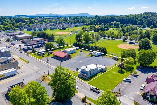
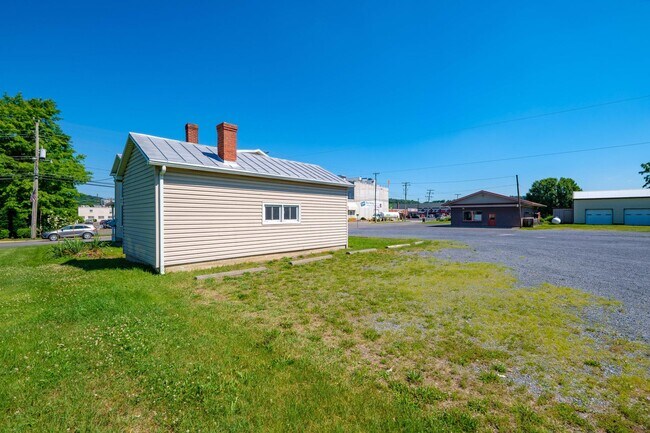
Property Record
522 N Main St, Bridgewater, VA 22812

NEARBY LISTINGS FOR SALE OR LEASE
-
-
View all Bridgewater listings for lease on LoopNet.com
Property Detail
522 N Main St
Harrisonburg, VA
Main St
122A2-A-L122
Rockingham
Sfr
Virginia
X
0.54 AC
51165C0389E
Staunton & Harrisonburg
2,320 SF
Other Market Areas
DEMOGRAPHICS near 522 N Main St
1 Mile
3 Mile
5 Mile
2024 Total Population
6,331
11,205
20,418
2029 Population
6,609
11,598
20,972
Pop Growth 2024-2029
+ 4.39%
+ 3.51%
+ 2.71%
Average Age
40
40
39
2024 Total Households
2,203
3,842
7,202
HH Growth 2024-2029
+ 4.72%
+ 3.67%
+ 2.74%
Median Household Inc
$71,473
$74,363
$71,734
Avg Household Size
2.30
2.40
2.50
2024 Avg HH Vehicles
2.00
2.00
2.00
Median Home Value
$314,706
$304,621
$298,791
Median Year Built
1986
1980
1987
Nearby Places
Map Layers
Map Styles
 Street
 Aerial
- Restaurants
- Banks
- Shops
- Fitness
- Groceries
SALE & LEASE HISTORY
LISTING DATE
SALE/LEASE

Jun 30, 2021
For Sale
Aug 05, 2022
For Lease
Nearby Properties
Address
Land Use
TOTAL SIZE
Lot Size
Zoning
Address
Land Use
TOTAL SIZE
Lot Size
Zoning
25,038 SF
56.59 AC
R1
Address
Land Use
TOTAL SIZE
Lot Size
Zoning
57.92 AC
I1
Address
Land Use
TOTAL SIZE
Lot Size
Zoning
260,792 SF
27.98 AC
P1
Address
Land Use
TOTAL SIZE
Lot Size
Zoning
4,841 SF
7.07 AC
R3
Address
Land Use
TOTAL SIZE
Lot Size
Zoning
7,463 SF
74.63 AC
I1
Address
Land Use
TOTAL SIZE
Lot Size
Zoning
130,426 SF
19.11 AC
R1
Address
Land Use
TOTAL SIZE
Lot Size
Zoning
16.52 AC
TOWN
Address
Land Use
TOTAL SIZE
Lot Size
Zoning
295,543 SF
33.23 AC
I1
Address
Land Use
TOTAL SIZE
Lot Size
Zoning
21.42 AC
I1
Address
Land Use
TOTAL SIZE
Lot Size
Zoning
4.82 AC
B1
Address
Land Use
TOTAL SIZE
Lot Size
Zoning
74,032 SF
20.64 AC
R3
Address
Land Use
TOTAL SIZE
Lot Size
Zoning
36,612 SF
12.78 AC
R3
Address
Land Use
TOTAL SIZE
Lot Size
Zoning
223,744 SF
5.50 AC
I1
Address
Land Use
TOTAL SIZE
Lot Size
Zoning
6,000 SF
10 AC
I1
Address
Land Use
TOTAL SIZE
Lot Size
Zoning
28,451 SF
0.20 AC
R3
Address
Land Use
TOTAL SIZE
Lot Size
Zoning
3.69 AC
M1
Address
Land Use
TOTAL SIZE
Lot Size
Zoning
3.63 AC
A2
Address
Land Use
TOTAL SIZE
Lot Size
Zoning
7,897 SF
6.53 AC
GENERAL BU
Address
Land Use
TOTAL SIZE
Lot Size
Zoning
216,000 SF
7.58 AC
I1
Address
Land Use
TOTAL SIZE
Lot Size
Zoning
53,524 SF
4.16 AC
R1
Address
Land Use
TOTAL SIZE
Lot Size
Zoning
16,300 SF
10.68 AC
A2
Address
Land Use
TOTAL SIZE
Lot Size
Zoning
49,648 SF
6 AC
B1
Address
Land Use
TOTAL SIZE
Lot Size
Zoning
21,920 SF
6.40 AC
A2
Address
Land Use
TOTAL SIZE
Lot Size
Zoning
23,071 SF
8.19 AC
B2
Address
Land Use
TOTAL SIZE
Lot Size
Zoning
20,160 SF
15.73 AC
P1
Address
Land Use
TOTAL SIZE
Lot Size
Zoning
100,000 SF
8.51 AC
I1
Address
Land Use
TOTAL SIZE
Lot Size
Zoning
15,336 SF
8.61 AC
B1
Address
Land Use
TOTAL SIZE
Lot Size
Zoning
38,989 SF
8.70 AC
A2
Address
Land Use
TOTAL SIZE
Lot Size
Zoning
17,545 SF
2.33 AC
R1
Address
Land Use
TOTAL SIZE
Lot Size
Zoning
23,080 SF
0.70 AC
R1
The World's #1 Commercial Real Estate Marketplace
Connect with us
© 2025 CoStar Group
The information above has been obtained from sources believed reliable. While we do not doubt its accuracy we have not verified it and make no guarantee, warranty or representation about it. It is your responsibility to independently confirm its accuracy and completeness. Any projections, opinions, assumptions, or estimates used are for example only and do not represent the current or future performance of the property. The value of this transaction to you depends on tax and other factors which should be evaluated by your tax, financial, and legal advisors. You and your advisors should conduct a careful, independent investigation of the property to determine to your satisfaction the suitability of the property for your needs.