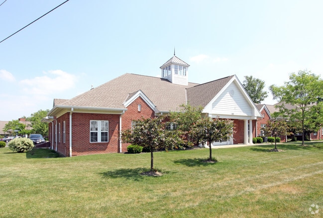
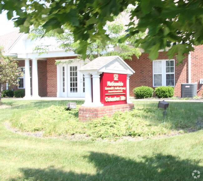
Property Record
522 N State St, Westerville, OH 43082


NEARBY LISTINGS FOR SALE OR LEASE
Property Detail
522 N State St
Columbus, OH
United States Military Lands
317-334-03-006-015
LANDS 17 3 3 23
Officebuilding
Delaware
X
Ohio
39041C0270K
23
2024
0.68 AC
2024
Outlying Delaware County
011710
Columbus
4,149 SF
DEMOGRAPHICS near 522 N State St
1 Mile
3 Mile
5 Mile
2024 Total Population
7,246
69,092
197,644
2029 Population
7,809
73,544
206,504
Pop Growth 2024-2029
+ 7.77%
+ 6.44%
+ 4.48%
Average Age
43
41
38
2024 Total Households
2,846
26,701
77,650
HH Growth 2024-2029
+ 8.92%
+ 6.57%
+ 4.32%
Median Household Inc
$95,074
$106,816
$86,169
Avg Household Size
2.30
2.50
2.50
2024 Avg HH Vehicles
2.00
2.00
2.00
Median Home Value
$315,701
$324,545
$295,703
Median Year Built
1994
1992
1988
Nearby Places
Map Layers
Map Styles
 Street
 Aerial
- Restaurants
- Banks
- Shops
- Fitness
- Groceries
PUBLIC TRANSPORTATION
AIRPORT
John Glenn Columbus International
DRIVE
WALK
Distance
John Glenn Columbus International
19 min
13.0 mi
Rickenbacker International
DRIVE
WALK
Distance
Rickenbacker International
37 min
27.4 mi
SALE & LEASE HISTORY
LISTING DATE
SALE/LEASE

Dec 03, 2018
For Lease
Nearby Properties
Address
Land Use
TOTAL SIZE
Lot Size
Zoning
Address
Land Use
TOTAL SIZE
Lot Size
Zoning
440,828 SF
13.72 AC
Address
Land Use
TOTAL SIZE
Lot Size
Zoning
534,330 SF
10.13 AC
Address
Land Use
TOTAL SIZE
Lot Size
Zoning
635,036 SF
45.24 AC
Address
Land Use
TOTAL SIZE
Lot Size
Zoning
426,490 SF
19.43 AC
Address
Land Use
TOTAL SIZE
Lot Size
Zoning
47,258 SF
50 AC
Address
Land Use
TOTAL SIZE
Lot Size
Zoning
446,516 SF
95.88 AC
Address
Land Use
TOTAL SIZE
Lot Size
Zoning
320,022 SF
37.14 AC
Address
Land Use
TOTAL SIZE
Lot Size
Zoning
697,077 SF
40.91 AC
Address
Land Use
TOTAL SIZE
Lot Size
Zoning
159,315 SF
13.25 AC
Address
Land Use
TOTAL SIZE
Lot Size
Zoning
218,891 SF
19.56 AC
Address
Land Use
TOTAL SIZE
Lot Size
Zoning
271,562 SF
5.79 AC
Address
Land Use
TOTAL SIZE
Lot Size
Zoning
354,123 SF
19.81 AC
Address
Land Use
TOTAL SIZE
Lot Size
Zoning
217,722 SF
67.75 AC
Address
Land Use
TOTAL SIZE
Lot Size
Zoning
169,697 SF
5.59 AC
Address
Land Use
TOTAL SIZE
Lot Size
Zoning
3,263 SF
989.66 AC
Address
Land Use
TOTAL SIZE
Lot Size
Zoning
134,311 SF
17.26 AC
Address
Land Use
TOTAL SIZE
Lot Size
Zoning
62,852 SF
15.56 AC
Address
Land Use
TOTAL SIZE
Lot Size
Zoning
262,768 SF
4.35 AC
Address
Land Use
TOTAL SIZE
Lot Size
Zoning
292,377 SF
36.29 AC
Address
Land Use
TOTAL SIZE
Lot Size
Zoning
151,248 SF
13.30 AC
Address
Land Use
TOTAL SIZE
Lot Size
Zoning
170,259 SF
16.30 AC
Address
Land Use
TOTAL SIZE
Lot Size
Zoning
137,489 SF
14.73 AC
Address
Land Use
TOTAL SIZE
Lot Size
Zoning
258,205 SF
5.13 AC
Address
Land Use
TOTAL SIZE
Lot Size
Zoning
249,112 SF
5.94 AC
Address
Land Use
TOTAL SIZE
Lot Size
Zoning
119,213 SF
25.43 AC
Address
Land Use
TOTAL SIZE
Lot Size
Zoning
140,337 SF
10.14 AC
Address
Land Use
TOTAL SIZE
Lot Size
Zoning
217,703 SF
8.55 AC
Address
Land Use
TOTAL SIZE
Lot Size
Zoning
142,998 SF
30.25 AC
Address
Land Use
TOTAL SIZE
Lot Size
Zoning
100,848 SF
9.72 AC
Address
Land Use
TOTAL SIZE
Lot Size
Zoning
80,608 SF
7.34 AC
The World's #1 Commercial Real Estate Marketplace
Connect with us
© 2025 CoStar Group
The information above has been obtained from sources believed reliable. While we do not doubt its accuracy we have not verified it and make no guarantee, warranty or representation about it. It is your responsibility to independently confirm its accuracy and completeness. Any projections, opinions, assumptions, or estimates used are for example only and do not represent the current or future performance of the property. The value of this transaction to you depends on tax and other factors which should be evaluated by your tax, financial, and legal advisors. You and your advisors should conduct a careful, independent investigation of the property to determine to your satisfaction the suitability of the property for your needs.