Property Record
522 Simpson Rd, Kissimmee, FL 34744

Save to a Folder
{{folder.Name}}
{{folder.ListingIds.length}} Properties
{{folder.ListingIds.length}} Property
Create a New Folder
Property Detail
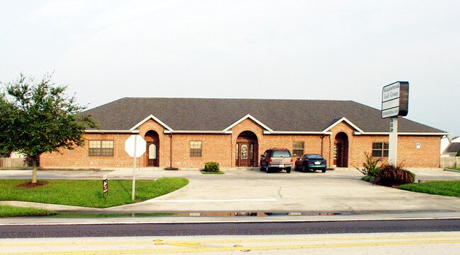
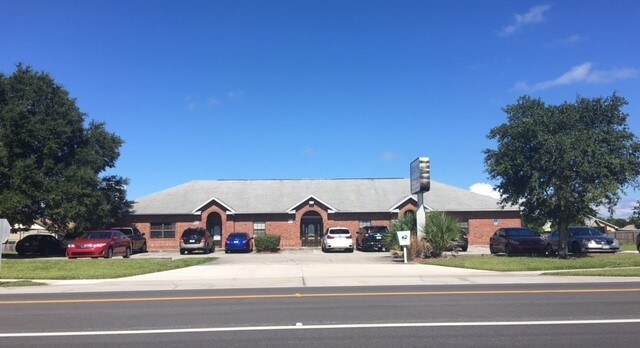
522 Simpson Rd
19-25-30-0000-0025-0000
COM AT PT OF INTER OF N LINE OF S 1/2 OF SE 1/4 OF NW 1/4 AND W R/W SIMPSON RD, S 200 FT TO POB; CONT S 145.68 FT, W 148 FT, N 145.68 FT, E 147.95 FT TO POB LESS COM AT CENTER OF 19-25-30, N00-21-07W 324.43 FT, S89-38-53W 33 FT TO PT ON W R/W LINE OF
Officebuilding
Osceola
OCR
Florida
B and X Area of moderate flood hazard, usually the area between the limits of the 100-year and 500-year floods.
25
2024
0.46 AC
2025
Osceola Outlying
042905
Orlando
4,330 SF
Orlando-Kissimmee-Sanford, FL
NEARBY LISTINGS FOR SALE OR LEASE
DEMOGRAPHICS near 522 Simpson Rd
1 mile
3 mile
5 mile
2025 Total Population
11,400
73,368
181,966
2030 Population
13,181
85,348
209,543
Pop Growth 2025-2030
+ 15.62%
+ 16.33%
+ 15.16%
Average Age
39
39
38
2025 Total Households
3,666
23,835
60,315
HH Growth 2025-2030
+ 16.34%
+ 16.95%
+ 15.83%
Median Household Inc
$59,915
$69,821
$70,209
Avg Household Size
2.90
3.00
3.00
2025 Avg HH Vehicles
2.00
2.00
2.00
Median Home Value
$306,752
$343,630
$351,792
Median Year Built
1998
1997
1998
Nearby Places
Map Layers
Map Styles
 Street
 Aerial
Layers
 Traffic
 Biking
Places
Listings with unknown addresses are not visible on the map
- Restaurants
- Banks
- Shops
- Fitness
- Groceries
PUBLIC TRANSPORTATION
COMMUTER RAIL
Drive
Walk
Distance
10 min
4.7 mi
Drive
Walk
Distance
12 min
6.9 mi
AIRPORT
Orlando International
Drive
Walk
Distance
Orlando International
22 min
12.0 mi
Orlando Sanford International
Drive
Walk
Distance
Orlando Sanford International
53 min
41.3 mi
Freight Ports
Port Canaveral
Drive
Walk
Distance
Port Canaveral
68 min
53.7 mi
SALE & LEASE HISTORY
LISTING DATE
SALE/LEASE

Sep 24, 2016
For Sale
Nov 28, 2016
For Sale
Apr 28, 2017
For Sale
Nearby Properties
Address
Land Use
TOTAL SIZE
Lot Size
Zoning
Address
Land Use
TOTAL SIZE
Lot Size
Zoning
457,374 SF
30.93 AC
OCT
Address
Land Use
TOTAL SIZE
Lot Size
Zoning
402,010 SF
22.33 AC
OCR
Address
Land Use
TOTAL SIZE
Lot Size
Zoning
334,569 SF
11.82 AC
Address
Land Use
TOTAL SIZE
Lot Size
Zoning
416,762 SF
99.87 AC
KCF
Address
Land Use
TOTAL SIZE
Lot Size
Zoning
343,107 SF
16.26 AC
OEC
Address
Land Use
TOTAL SIZE
Lot Size
Zoning
379,943 SF
14.07 AC
OCT
Address
Land Use
TOTAL SIZE
Lot Size
Zoning
142,570 SF
20.16 AC
OPD
Address
Land Use
TOTAL SIZE
Lot Size
Zoning
351,537 SF
44.58 AC
OPD
Address
Land Use
TOTAL SIZE
Lot Size
Zoning
437,037 SF
34.76 AC
OPUD
Address
Land Use
TOTAL SIZE
Lot Size
Zoning
188,719 SF
10.81 AC
Address
Land Use
TOTAL SIZE
Lot Size
Zoning
203,711 SF
10.27 AC
Address
Land Use
TOTAL SIZE
Lot Size
Zoning
374,081 SF
36.66 AC
KRC1
Address
Land Use
TOTAL SIZE
Lot Size
Zoning
187,302 SF
20.85 AC
Address
Land Use
TOTAL SIZE
Lot Size
Zoning
152,370 SF
14.05 AC
OCR
Address
Land Use
TOTAL SIZE
Lot Size
Zoning
343,593 SF
49.46 AC
OAC
Address
Land Use
TOTAL SIZE
Lot Size
Zoning
145,028 SF
6.85 AC
Address
Land Use
TOTAL SIZE
Lot Size
Zoning
57,939 SF
80.04 AC
OPD
Address
Land Use
TOTAL SIZE
Lot Size
Zoning
309,075 SF
16.94 AC
OPUD
Address
Land Use
TOTAL SIZE
Lot Size
Zoning
304,494 SF
15.67 AC
Address
Land Use
TOTAL SIZE
Lot Size
Zoning
258,588 SF
119.70 AC
OAC
Address
Land Use
TOTAL SIZE
Lot Size
Zoning
73,910 SF
4.61 AC
OCT
Address
Land Use
TOTAL SIZE
Lot Size
Zoning
113,079 SF
8.96 AC
OCT
Address
Land Use
TOTAL SIZE
Lot Size
Zoning
170,800 SF
44.94 AC
KCF
Address
Land Use
TOTAL SIZE
Lot Size
Zoning
105,918 SF
13.34 AC
KHC
Address
Land Use
TOTAL SIZE
Lot Size
Zoning
63,524 SF
10.88 AC
OCR
Address
Land Use
TOTAL SIZE
Lot Size
Zoning
42,528 SF
17 AC
ORM3
Address
Land Use
TOTAL SIZE
Lot Size
Zoning
113,362 SF
40.78 AC
OPUD
Address
Land Use
TOTAL SIZE
Lot Size
Zoning
66,171 SF
8.42 AC
OCR
Address
Land Use
TOTAL SIZE
Lot Size
Zoning
91,320 SF
1.90 AC
OCR
Address
Land Use
TOTAL SIZE
Lot Size
Zoning
137,208 SF
37.64 AC
OAC
The World's #1 Commercial Real Estate Marketplace
Connect with us
© 2026 CoStar Group
The information above has been obtained from sources believed reliable. While we do not doubt its accuracy we have not verified it and make no guarantee, warranty or representation about it. It is your responsibility to independently confirm its accuracy and completeness. Any projections, opinions, assumptions, or estimates used are for example only and do not represent the current or future performance of the property. The value of this transaction to you depends on tax and other factors which should be evaluated by your tax, financial, and legal advisors. You and your advisors should conduct a careful, independent investigation of the property to determine to your satisfaction the suitability of the property for your needs.