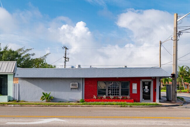
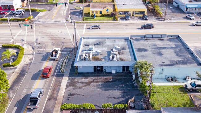
Property Record
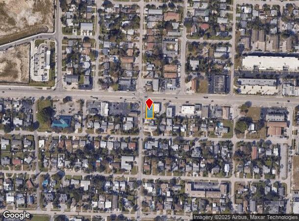
522 W Lantana Rd, Lantana, FL 33462
NEARBY LISTINGS FOR SALE OR LEASE
Property Detail
522 W Lantana Rd
West Palm Beach-Boca Raton-Delray Beach, FL
Amended Plat Of Lantana
40-43-45-03-10-005-0111
AMENDED PLAT OF LANTANA W 1 FT OF LT 11 (N 15 FT RD R/W) & LT 12 (LESS N 15 FT & EXTERNAL CURVE AREA FOR RD R/W) BLK 5
Storemultistory
Palm Beach
X
Florida
12099C0783F
11,12
2024
0.12 AC
2025
Boynton/Lantana
005502
South Florida
2,116 SF
DEMOGRAPHICS near 522 W Lantana Rd
1 Mile
3 Mile
5 Mile
2024 Total Population
15,826
102,353
246,550
2029 Population
16,750
107,377
256,074
Pop Growth 2024-2029
+ 5.84%
+ 4.91%
+ 3.86%
Average Age
40
42
41
2024 Total Households
6,293
40,312
93,890
HH Growth 2024-2029
+ 6.02%
+ 5.39%
+ 4.11%
Median Household Inc
$61,752
$61,876
$64,043
Avg Household Size
2.40
2.40
2.50
2024 Avg HH Vehicles
2.00
2.00
2.00
Median Home Value
$305,464
$293,488
$302,008
Median Year Built
1974
1978
1981
Nearby Places
Map Layers
Map Styles
 Street
 Aerial
- Restaurants
- Banks
- Shops
- Fitness
- Groceries
PUBLIC TRANSPORTATION
COMMUTER RAIL
Lake Worth (Tri-County Commuter - South Florida Regional Transportation Authority (Tri-Rail))
DRIVE
WALK
Distance
Lake Worth (Tri-County Commuter - South Florida Regional Transportation Authority (Tri-Rail))
8 min
3.3 mi
Boynton Beach (Tri-County Commuter - South Florida Regional Transportation Authority (Tri-Rail))
DRIVE
WALK
Distance
Boynton Beach (Tri-County Commuter - South Florida Regional Transportation Authority (Tri-Rail))
6 min
3.9 mi
AIRPORT
Palm Beach International
DRIVE
WALK
Distance
Palm Beach International
15 min
10.3 mi
Freight Ports
Port of Palm Beach
DRIVE
WALK
Distance
Port of Palm Beach
1 min
12.7 mi
SALE & LEASE HISTORY
LISTING DATE
SALE/LEASE

Jun 22, 2022
For Sale
Aug 02, 2021
For Sale
Nearby Properties
Address
Land Use
TOTAL SIZE
Lot Size
Zoning
Address
Land Use
TOTAL SIZE
Lot Size
Zoning
337,437 SF
8.01 AC
C3
Address
Land Use
TOTAL SIZE
Lot Size
Zoning
1,346,412 SF
23.09 AC
HD PUD
Address
Land Use
TOTAL SIZE
Lot Size
Zoning
245,283 SF
7.40 AC
R-D(2)
Address
Land Use
TOTAL SIZE
Lot Size
Zoning
902,798 SF
112.99 AC
PO
Address
Land Use
TOTAL SIZE
Lot Size
Zoning
81,194 SF
675.47 AC
PO
Address
Land Use
TOTAL SIZE
Lot Size
Zoning
508,032 SF
18 AC
MXD
Address
Land Use
TOTAL SIZE
Lot Size
Zoning
357,168 SF
16.13 AC
MXD
Address
Land Use
TOTAL SIZE
Lot Size
Zoning
327,864 SF
9.21 AC
MW
Address
Land Use
TOTAL SIZE
Lot Size
Zoning
311,983 SF
7.15 AC
C1
Address
Land Use
TOTAL SIZE
Lot Size
Zoning
443,576 SF
92.86 AC
PO
Address
Land Use
TOTAL SIZE
Lot Size
Zoning
211,774 SF
304.50 AC
PO
Address
Land Use
TOTAL SIZE
Lot Size
Zoning
353,007 SF
33.60 AC
RS
Address
Land Use
TOTAL SIZE
Lot Size
Zoning
214,095 SF
7.67 AC
PUD
Address
Land Use
TOTAL SIZE
Lot Size
Zoning
113,115 SF
3.18 AC
R-D(2)
Address
Land Use
TOTAL SIZE
Lot Size
Zoning
240,786 SF
10.63 AC
R3
Address
Land Use
TOTAL SIZE
Lot Size
Zoning
476,774 SF
38.76 AC
RM
Address
Land Use
TOTAL SIZE
Lot Size
Zoning
99,412 SF
2.67 AC
R-D(2)
Address
Land Use
TOTAL SIZE
Lot Size
Zoning
296,033 SF
2.04 AC
TOD-E
Address
Land Use
TOTAL SIZE
Lot Size
Zoning
291,589 SF
11.63 AC
PID
Address
Land Use
TOTAL SIZE
Lot Size
Zoning
178,602 SF
7.61 AC
MU-W
Address
Land Use
TOTAL SIZE
Lot Size
Zoning
251,292 SF
18.59 AC
I-POC
Address
Land Use
TOTAL SIZE
Lot Size
Zoning
215,310 SF
21.35 AC
PUD
Address
Land Use
TOTAL SIZE
Lot Size
Zoning
344,466 SF
24.37 AC
P
Address
Land Use
TOTAL SIZE
Lot Size
Zoning
263,799 SF
8.36 AC
PUD
Address
Land Use
TOTAL SIZE
Lot Size
Zoning
12,856 SF
2.03 AC
R1-C
Address
Land Use
TOTAL SIZE
Lot Size
Zoning
201,733 SF
11.32 AC
RM
Address
Land Use
TOTAL SIZE
Lot Size
Zoning
84,999 SF
10.28 AC
R-C2
Address
Land Use
TOTAL SIZE
Lot Size
Zoning
142,635 SF
10.66 AC
PID
Address
Land Use
TOTAL SIZE
Lot Size
Zoning
7,284 SF
19.49 AC
BAC
Address
Land Use
TOTAL SIZE
Lot Size
Zoning
11,762 SF
1.46 AC
R1-C
The World's #1 Commercial Real Estate Marketplace
Connect with us
© 2025 CoStar Group
The information above has been obtained from sources believed reliable. While we do not doubt its accuracy we have not verified it and make no guarantee, warranty or representation about it. It is your responsibility to independently confirm its accuracy and completeness. Any projections, opinions, assumptions, or estimates used are for example only and do not represent the current or future performance of the property. The value of this transaction to you depends on tax and other factors which should be evaluated by your tax, financial, and legal advisors. You and your advisors should conduct a careful, independent investigation of the property to determine to your satisfaction the suitability of the property for your needs.