Property Record
522 W Main St, Tilton, NH 03276
This Property Is For Sale
NEARBY LISTINGS FOR SALE OR LEASE
Property Detail
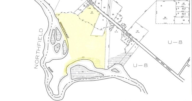
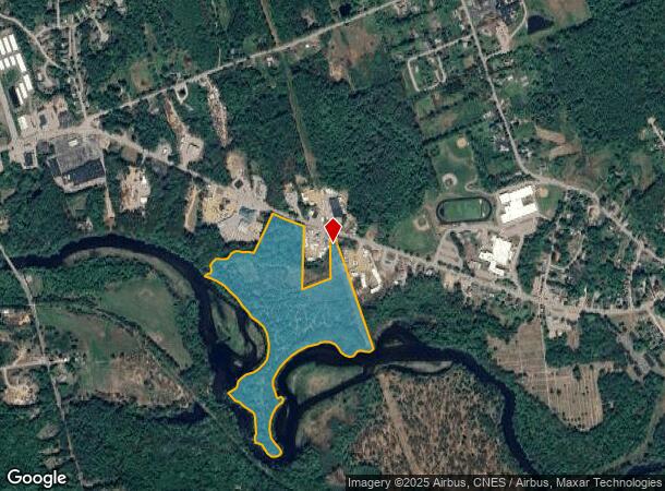
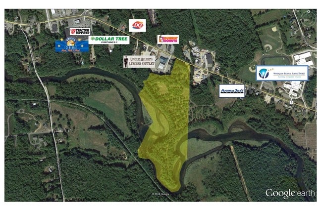
522 W Main St
Laconia, NH
Belknap
TILT-000026R-000010
New Hampshire
Residentialacreage
39.91 AC
2024
Concord/New Hampshire North Area
2024
Other Market Areas
965598
DEMOGRAPHICS near 522 W Main St
1 Mile
3 Mile
5 Mile
2024 Total Population
2,675
13,735
19,290
2029 Population
2,771
14,466
20,286
Pop Growth 2024-2029
+ 3.59%
+ 5.32%
+ 5.16%
Average Age
43
42
43
2024 Total Households
1,060
5,583
7,847
HH Growth 2024-2029
+ 3.30%
+ 5.19%
+ 5.00%
Median Household Inc
$54,819
$62,163
$64,644
Avg Household Size
2.30
2.30
2.40
2024 Avg HH Vehicles
2.00
2.00
2.00
Median Home Value
$225,336
$224,335
$235,040
Median Year Built
1970
1967
1971
Nearby Places
Map Layers
Map Styles
 Street
 Aerial
- Restaurants
- Banks
- Shops
- Fitness
- Groceries
Nearby Properties
Address
Land Use
TOTAL SIZE
Lot Size
Zoning
Address
Land Use
TOTAL SIZE
Lot Size
Zoning
239,745 SF
26.87 AC
REGION
Address
Land Use
TOTAL SIZE
Lot Size
Zoning
149,800 SF
28 AC
MEDIUM
Address
Land Use
TOTAL SIZE
Lot Size
Zoning
1.04 AC
MIXED
Address
Land Use
TOTAL SIZE
Lot Size
Zoning
118,611 SF
12.40 AC
VILLAG
Address
Land Use
TOTAL SIZE
Lot Size
Zoning
6,544 SF
20 AC
CONSVC
Address
Land Use
TOTAL SIZE
Lot Size
Zoning
1,974 SF
5.30 AC
REGION
Address
Land Use
TOTAL SIZE
Lot Size
Zoning
58,142 SF
7 AC
VILLAG
Address
Land Use
TOTAL SIZE
Lot Size
Zoning
146,540 SF
18.75 AC
REGION
Address
Land Use
TOTAL SIZE
Lot Size
Zoning
90,391 SF
10.01 AC
REGION
Address
Land Use
TOTAL SIZE
Lot Size
Zoning
48,809 SF
10.83 AC
REGION
Address
Land Use
TOTAL SIZE
Lot Size
Zoning
143,764 SF
18.64 AC
REGION
Address
Land Use
TOTAL SIZE
Lot Size
Zoning
64,666 SF
8.65 AC
RSW&S
Address
Land Use
TOTAL SIZE
Lot Size
Zoning
121,485 SF
19.49 AC
REGION
Address
Land Use
TOTAL SIZE
Lot Size
Zoning
68,029 SF
30.94 AC
REGION
Address
Land Use
TOTAL SIZE
Lot Size
Zoning
56,132 SF
9.74 AC
REGION
Address
Land Use
TOTAL SIZE
Lot Size
Zoning
Address
Land Use
TOTAL SIZE
Lot Size
Zoning
80,933 SF
3.79 AC
VILLAG
Address
Land Use
TOTAL SIZE
Lot Size
Zoning
58,039 SF
2.48 AC
REGION
Address
Land Use
TOTAL SIZE
Lot Size
Zoning
70,207 SF
7.73 AC
REGION
Address
Land Use
TOTAL SIZE
Lot Size
Zoning
16,833 SF
2.39 AC
B1W&S
Address
Land Use
TOTAL SIZE
Lot Size
Zoning
68,304 SF
11.62 AC
REGION
Address
Land Use
TOTAL SIZE
Lot Size
Zoning
106,189 SF
9.06 AC
C/I-2
Address
Land Use
TOTAL SIZE
Lot Size
Zoning
42,523 SF
32.89 AC
R1SFSS
Address
Land Use
TOTAL SIZE
Lot Size
Zoning
93,102 SF
8.21 AC
GENERA
Address
Land Use
TOTAL SIZE
Lot Size
Zoning
20,276 SF
13.02 AC
VILLAG
Address
Land Use
TOTAL SIZE
Lot Size
Zoning
60.27 AC
R2MFSM
Address
Land Use
TOTAL SIZE
Lot Size
Zoning
83,283 SF
16.81 AC
RSW&S
Address
Land Use
TOTAL SIZE
Lot Size
Zoning
17,338 SF
4.07 AC
VILLAG
Address
Land Use
TOTAL SIZE
Lot Size
Zoning
38,407 SF
2.26 AC
REGION
Address
Land Use
TOTAL SIZE
Lot Size
Zoning
38,159 SF
4 AC
R2MFSM
The World's #1 Commercial Real Estate Marketplace
Connect with us
© 2025 CoStar Group
The information above has been obtained from sources believed reliable. While we do not doubt its accuracy we have not verified it and make no guarantee, warranty or representation about it. It is your responsibility to independently confirm its accuracy and completeness. Any projections, opinions, assumptions, or estimates used are for example only and do not represent the current or future performance of the property. The value of this transaction to you depends on tax and other factors which should be evaluated by your tax, financial, and legal advisors. You and your advisors should conduct a careful, independent investigation of the property to determine to your satisfaction the suitability of the property for your needs.