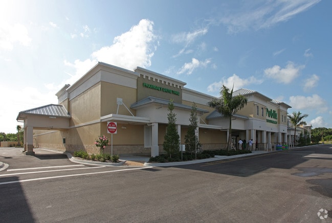
Property Record
5220 Us Highway 1, Vero Beach, FL 32967
NEARBY LISTINGS FOR SALE OR LEASE
Property Detail
5220 Us Highway 1
Sebastian-Vero Beach, FL
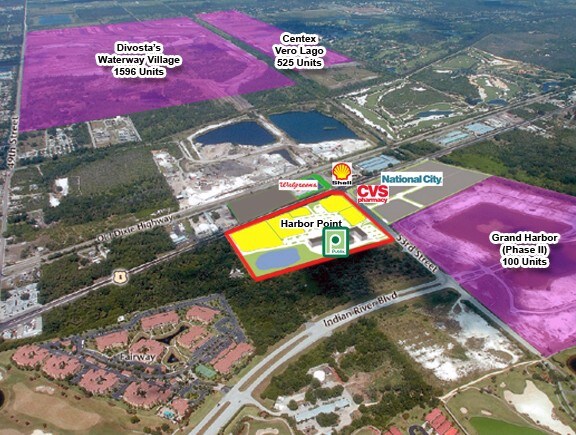
Harbor Point A Commerical Sub
32-39-23-00029-0000-00005.0
HARBOR POINT A COMMERICAL SUB LOT 5 PBI 27-27
Regionalshoppingcenterormallwithanchorstore
Indian River
X
Florida
12061C0233J
5
2025
10.45 AC
2025
Fort Pierce/Port St Lucie
050305
Other Market Areas
72,397 SF
DEMOGRAPHICS near 5220 Us Highway 1
1 Mile
3 Mile
5 Mile
2024 Total Population
3,955
25,381
66,946
2029 Population
4,502
28,743
75,804
Pop Growth 2024-2029
+ 13.83%
+ 13.25%
+ 13.23%
Average Age
52
53
52
2024 Total Households
1,906
11,436
31,307
HH Growth 2024-2029
+ 13.69%
+ 13.04%
+ 13.00%
Median Household Inc
$63,768
$67,704
$60,265
Avg Household Size
2.00
2.10
2.00
2024 Avg HH Vehicles
1.00
2.00
2.00
Median Home Value
$354,926
$383,302
$358,766
Median Year Built
2001
1997
1989
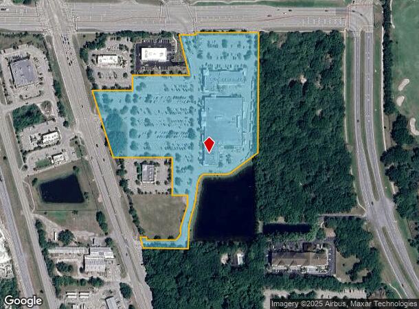
Nearby Places
Map Layers
Map Styles
 Street
 Aerial
- Restaurants
- Banks
- Shops
- Fitness
- Groceries
SALE & LEASE HISTORY
LISTING DATE
SALE/LEASE

Dec 11, 2017
For Lease
Nearby Properties
Address
Land Use
TOTAL SIZE
Lot Size
Zoning
Address
Land Use
TOTAL SIZE
Lot Size
Zoning
634,259 SF
53.45 AC
MED
Address
Land Use
TOTAL SIZE
Lot Size
Zoning
571,211 SF
26.38 AC
RM-10
Address
Land Use
TOTAL SIZE
Lot Size
Zoning
21,228 SF
145.79 AC
A-1
Address
Land Use
TOTAL SIZE
Lot Size
Zoning
240,516 SF
39.71 AC
RM-8
Address
Land Use
TOTAL SIZE
Lot Size
Zoning
39,873 SF
7.61 AC
GU
Address
Land Use
TOTAL SIZE
Lot Size
Zoning
2,133 SF
772.04 AC
ALI-A1
Address
Land Use
TOTAL SIZE
Lot Size
Zoning
46,567 SF
19.61 AC
CG
Address
Land Use
TOTAL SIZE
Lot Size
Zoning
12,151 SF
2.52 AC
R-1A
Address
Land Use
TOTAL SIZE
Lot Size
Zoning
100 SF
5.46 AC
R-1A
Address
Land Use
TOTAL SIZE
Lot Size
Zoning
106,904 SF
79.05 AC
M
Address
Land Use
TOTAL SIZE
Lot Size
Zoning
124.80 AC
Address
Land Use
TOTAL SIZE
Lot Size
Zoning
235,921 SF
28.80 AC
RM-8
Address
Land Use
TOTAL SIZE
Lot Size
Zoning
67,334 SF
9.63 AC
MED
Address
Land Use
TOTAL SIZE
Lot Size
Zoning
8,087 SF
1.44 AC
R-1A
Address
Land Use
TOTAL SIZE
Lot Size
Zoning
69,942 SF
10.47 AC
MED
Address
Land Use
TOTAL SIZE
Lot Size
Zoning
4,364 SF
0.64 AC
R-1A
Address
Land Use
TOTAL SIZE
Lot Size
Zoning
91,904 SF
10 AC
CG
Address
Land Use
TOTAL SIZE
Lot Size
Zoning
3,540 SF
217.55 AC
ALI-A2
Address
Land Use
TOTAL SIZE
Lot Size
Zoning
29,804 SF
498.76 AC
CON-1
Address
Land Use
TOTAL SIZE
Lot Size
Zoning
9,118 SF
1.48 AC
R-1A
Address
Land Use
TOTAL SIZE
Lot Size
Zoning
5,524 SF
0.51 AC
R-1A
Address
Land Use
TOTAL SIZE
Lot Size
Zoning
1.30 AC
R-1A
Address
Land Use
TOTAL SIZE
Lot Size
Zoning
12,908 SF
1.26 AC
R-1A
Address
Land Use
TOTAL SIZE
Lot Size
Zoning
221.70 AC
MPZ
Address
Land Use
TOTAL SIZE
Lot Size
Zoning
4,742 SF
38.96 AC
RS-6
Address
Land Use
TOTAL SIZE
Lot Size
Zoning
94,187 SF
9.15 AC
MED
Address
Land Use
TOTAL SIZE
Lot Size
Zoning
0.92 AC
R-2A
Address
Land Use
TOTAL SIZE
Lot Size
Zoning
6,898 SF
1.18 AC
R-1A
Address
Land Use
TOTAL SIZE
Lot Size
Zoning
1.03 AC
R-1A
The World's #1 Commercial Real Estate Marketplace
Connect with us
© 2025 CoStar Group
The information above has been obtained from sources believed reliable. While we do not doubt its accuracy we have not verified it and make no guarantee, warranty or representation about it. It is your responsibility to independently confirm its accuracy and completeness. Any projections, opinions, assumptions, or estimates used are for example only and do not represent the current or future performance of the property. The value of this transaction to you depends on tax and other factors which should be evaluated by your tax, financial, and legal advisors. You and your advisors should conduct a careful, independent investigation of the property to determine to your satisfaction the suitability of the property for your needs.