Property Record
5220 N State St, Jackson, MS 39206
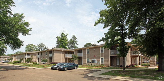

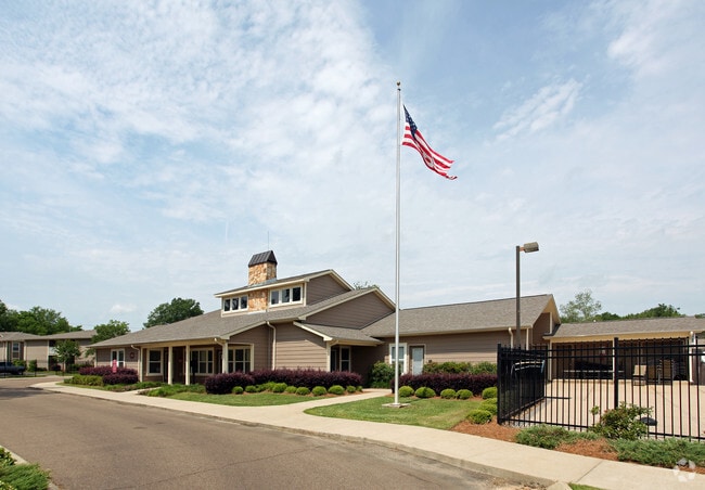
Property Detail
5220 N State St
0517-0851-000
BEG 205.37 FT E INT E/L N STATE ST & N/L CORNELL ESTATES PARTITION E 1176.07 FT S 712.27 FT W 1423.27 FT NELY 112.41 FT WLY 115.49 FT NELY 655.89 FT TO POB IN N 1/2 SEC 14 T6 R1E LESS TO WOODWAY DRIVE
Apartment
HINDS
AE The base floodplain where base flood elevations are provided. AE Zones are now used on new format FIRMs instead of A1-A30 Zones.
Mississippi
2024
24 AC
2025
North Jackson
000500
Jackson
302,370 SF
Jackson, MS
NEARBY LISTINGS FOR SALE OR LEASE
DEMOGRAPHICS near 5220 N State St
1 mile
3 mile
5 mile
2025 Total Population
7,892
46,809
99,752
2030 Population
7,537
44,617
98,127
Pop Growth 2025-2030
(4.50%)
(4.68%)
(1.63%)
Average Age
36
39
39
2025 Total Households
3,388
20,283
44,006
HH Growth 2025-2030
(4.84%)
(4.81%)
(1.74%)
Median Household Inc
$39,916
$52,732
$50,252
Avg Household Size
2.30
2.20
2.20
2025 Avg HH Vehicles
2.00
2.00
2.00
Median Home Value
$98,086
$173,529
$174,007
Median Year Built
1967
1968
1973
Nearby Places
Map Layers
Map Styles
 Street
 Aerial
Transit
 Traffic
 Biking
Places
Listings with unknown addresses are not visible on the map
- Restaurants
- Banks
- Shops
- Fitness
- Groceries
PUBLIC TRANSPORTATION
AIRPORT
Jackson-Medgar Wiley Evers International
Drive
Walk
Distance
Jackson-Medgar Wiley Evers International
23 min
13.1 mi
Nearby Properties
Address
Land Use
TOTAL SIZE
Lot Size
Zoning
Address
Land Use
TOTAL SIZE
Lot Size
Zoning
7,561 SF
153.82 AC
Address
Land Use
TOTAL SIZE
Lot Size
Zoning
40,445 SF
3 AC
Address
Land Use
TOTAL SIZE
Lot Size
Zoning
51,260 SF
1 AC
Address
Land Use
TOTAL SIZE
Lot Size
Zoning
33,960 SF
19,602 AC
Address
Land Use
TOTAL SIZE
Lot Size
Zoning
236.80 AC
Address
Land Use
TOTAL SIZE
Lot Size
Zoning
59,840 SF
2.72 AC
Address
Land Use
TOTAL SIZE
Lot Size
Zoning
55,160 SF
3 AC
Address
Land Use
TOTAL SIZE
Lot Size
Zoning
64,949 SF
3 AC
Address
Land Use
TOTAL SIZE
Lot Size
Zoning
105,600 SF
13 AC
Address
Land Use
TOTAL SIZE
Lot Size
Zoning
54,291 SF
6.99 AC
Address
Land Use
TOTAL SIZE
Lot Size
Zoning
49,949 SF
10 AC
Address
Land Use
TOTAL SIZE
Lot Size
Zoning
57,234 SF
Address
Land Use
TOTAL SIZE
Lot Size
Zoning
102,249 SF
14.38 AC
Address
Land Use
TOTAL SIZE
Lot Size
Zoning
10,620 SF
2.81 AC
Address
Land Use
TOTAL SIZE
Lot Size
Zoning
15,374 SF
0.64 AC
Address
Land Use
TOTAL SIZE
Lot Size
Zoning
230,401 SF
643,381.54 AC
Address
Land Use
TOTAL SIZE
Lot Size
Zoning
108,198 SF
15.40 AC
Address
Land Use
TOTAL SIZE
Lot Size
Zoning
4.38 AC
Address
Land Use
TOTAL SIZE
Lot Size
Zoning
20.54 AC
Address
Land Use
TOTAL SIZE
Lot Size
Zoning
310,650 SF
17 AC
Address
Land Use
TOTAL SIZE
Lot Size
Zoning
23,589 SF
110,808.08 AC
Address
Land Use
TOTAL SIZE
Lot Size
Zoning
93.67 AC
Address
Land Use
TOTAL SIZE
Lot Size
Zoning
78,239 SF
4 AC
Address
Land Use
TOTAL SIZE
Lot Size
Zoning
9,003 SF
1 AC
Address
Land Use
TOTAL SIZE
Lot Size
Zoning
34,821 SF
2 AC
Address
Land Use
TOTAL SIZE
Lot Size
Zoning
3,370 SF
13.37 AC
Address
Land Use
TOTAL SIZE
Lot Size
Zoning
26,875 SF
3 AC
Address
Land Use
TOTAL SIZE
Lot Size
Zoning
81,911 SF
15.53 AC
Address
Land Use
TOTAL SIZE
Lot Size
Zoning
148,195 SF
11.66 AC
Address
Land Use
TOTAL SIZE
Lot Size
Zoning
139,497 SF
12 AC
The World's #1 Commercial Real Estate Marketplace
Connect with us
© 2026 CoStar Group
The information above has been obtained from sources believed reliable. While we do not doubt its accuracy we have not verified it and make no guarantee, warranty or representation about it. It is your responsibility to independently confirm its accuracy and completeness. Any projections, opinions, assumptions, or estimates used are for example only and do not represent the current or future performance of the property. The value of this transaction to you depends on tax and other factors which should be evaluated by your tax, financial, and legal advisors. You and your advisors should conduct a careful, independent investigation of the property to determine to your satisfaction the suitability of the property for your needs.