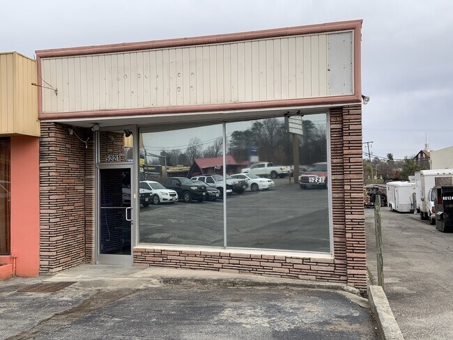
Property Record
5221 Williamson Rd, Roanoke, VA 24012
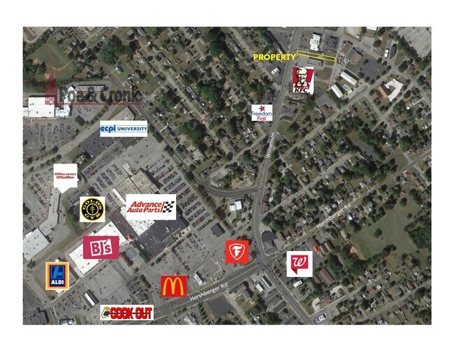
NEARBY LISTINGS FOR SALE OR LEASE
Property Detail
5221 Williamson Rd
Roanoke, VA
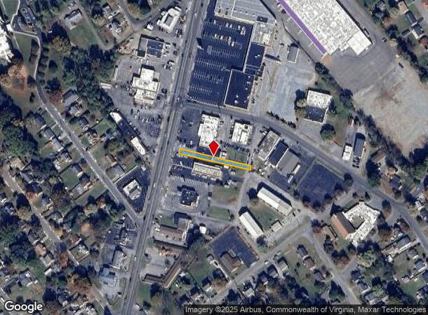
The Map Of Church Court
2200227
CENTRAL PT LOT 1 BLK 7 CHURCH CT
Multipleuses
Roanoke City
X
Virginia
51023C0455C
1
2025
0.15 AC
2025
Northeast Roanoke
000400
Roanoke
1,370 SF
DEMOGRAPHICS near 5221 Williamson Rd
1 Mile
3 Mile
5 Mile
2024 Total Population
9,803
53,939
122,269
2029 Population
9,665
53,159
120,806
Pop Growth 2024-2029
(1.41%)
(1.45%)
(1.20%)
Average Age
42
40
40
2024 Total Households
4,162
22,346
52,537
HH Growth 2024-2029
(1.37%)
(1.45%)
(1.24%)
Median Household Inc
$51,770
$50,769
$52,015
Avg Household Size
2.20
2.30
2.20
2024 Avg HH Vehicles
2.00
2.00
2.00
Median Home Value
$154,006
$164,644
$175,038
Median Year Built
1963
1967
1964
Nearby Places
Map Layers
Map Styles
 Street
 Aerial
- Restaurants
- Banks
- Shops
- Fitness
- Groceries
PUBLIC TRANSPORTATION
COMMUTER RAIL
DRIVE
WALK
Distance
8 min
4.5 mi
AIRPORT
Roanoke/Blacksburg Regional (Woodrum Field)
DRIVE
WALK
Distance
Roanoke/Blacksburg Regional (Woodrum Field)
6 min
2.0 mi
SALE & LEASE HISTORY
LISTING DATE
SALE/LEASE

Jan 24, 2020
For Sale
Nearby Properties
Address
Land Use
TOTAL SIZE
Lot Size
Zoning
Address
Land Use
TOTAL SIZE
Lot Size
Zoning
8,930 SF
604.76 AC
AD
Address
Land Use
TOTAL SIZE
Lot Size
Zoning
3,850 SF
60.20 AC
INPUD
Address
Land Use
TOTAL SIZE
Lot Size
Zoning
437,578 SF
14.74 AC
CLS
Address
Land Use
TOTAL SIZE
Lot Size
Zoning
219,494 SF
12.01 AC
CLS
Address
Land Use
TOTAL SIZE
Lot Size
Zoning
49,887 SF
2.28 AC
C1
Address
Land Use
TOTAL SIZE
Lot Size
Zoning
67,903 SF
11.96 AC
I2
Address
Land Use
TOTAL SIZE
Lot Size
Zoning
142,048 SF
21.38 AC
I-1
Address
Land Use
TOTAL SIZE
Lot Size
Zoning
609,211 SF
41.01 AC
I1C
Address
Land Use
TOTAL SIZE
Lot Size
Zoning
206,978 SF
19.45 AC
CLS
Address
Land Use
TOTAL SIZE
Lot Size
Zoning
29.63 AC
I-1
Address
Land Use
TOTAL SIZE
Lot Size
Zoning
15,312 SF
182.27 AC
AG3
Address
Land Use
TOTAL SIZE
Lot Size
Zoning
10,878 SF
10.34 AC
RMF
Address
Land Use
TOTAL SIZE
Lot Size
Zoning
207,812 SF
22.62 AC
CLS
Address
Land Use
TOTAL SIZE
Lot Size
Zoning
123,651 SF
29.38 AC
R2S
Address
Land Use
TOTAL SIZE
Lot Size
Zoning
164,753 SF
5.45 AC
INPUD
Address
Land Use
TOTAL SIZE
Lot Size
Zoning
71,238 SF
3.62 AC
CLS
Address
Land Use
TOTAL SIZE
Lot Size
Zoning
71,590 SF
2.49 AC
CLS
Address
Land Use
TOTAL SIZE
Lot Size
Zoning
2,688 SF
21.40 AC
RMF
Address
Land Use
TOTAL SIZE
Lot Size
Zoning
124,725 SF
6.53 AC
I1
Address
Land Use
TOTAL SIZE
Lot Size
Zoning
48,935 SF
9.15 AC
RMF
Address
Land Use
TOTAL SIZE
Lot Size
Zoning
32,080 SF
16 AC
INPUD
Address
Land Use
TOTAL SIZE
Lot Size
Zoning
13,128 SF
8.77 AC
RMF
Address
Land Use
TOTAL SIZE
Lot Size
Zoning
139,654 SF
4.77 AC
C2S
Address
Land Use
TOTAL SIZE
Lot Size
Zoning
1.86 AC
CLS
Address
Land Use
TOTAL SIZE
Lot Size
Zoning
22,950 SF
9.50 AC
R3
Address
Land Use
TOTAL SIZE
Lot Size
Zoning
198,089 SF
46.65 AC
AD
Address
Land Use
TOTAL SIZE
Lot Size
Zoning
12,018 SF
8.78 AC
RMF
Address
Land Use
TOTAL SIZE
Lot Size
Zoning
162,236 SF
13.71 AC
CLS
Address
Land Use
TOTAL SIZE
Lot Size
Zoning
106,884 SF
16.20 AC
R1S
Address
Land Use
TOTAL SIZE
Lot Size
Zoning
90,571 SF
10.34 AC
INPUD
The World's #1 Commercial Real Estate Marketplace
Connect with us
© 2026 CoStar Group
The information above has been obtained from sources believed reliable. While we do not doubt its accuracy we have not verified it and make no guarantee, warranty or representation about it. It is your responsibility to independently confirm its accuracy and completeness. Any projections, opinions, assumptions, or estimates used are for example only and do not represent the current or future performance of the property. The value of this transaction to you depends on tax and other factors which should be evaluated by your tax, financial, and legal advisors. You and your advisors should conduct a careful, independent investigation of the property to determine to your satisfaction the suitability of the property for your needs.