Property Record
5225 S Coulter St, Amarillo, TX 79119


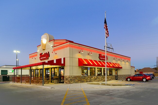
Property Detail
5225 S Coulter St
Amarillo, TX
City Park # 20
R-009-1110-1800-0
CITY PARK # 20, LOT 09A, BLK 0001, 0.8500 ACRES
Restaurantdrivein
Randall
X
Texas
48375C0520C
9a
2024
0.85 AC
2025
Amarillo
021605
Other Market Areas
3,780 SF
NEARBY LISTINGS FOR SALE OR LEASE
DEMOGRAPHICS near 5225 S Coulter St
1 mile
3 mile
5 mile
2024 Total Population
10,567
74,741
126,988
2029 Population
11,632
81,586
135,833
Pop Growth 2024-2029
+ 10.08%
+ 9.16%
+ 6.97%
Average Age
43
40
39
2024 Total Households
4,547
31,827
52,895
HH Growth 2024-2029
+ 10.07%
+ 9.32%
+ 6.96%
Median Household Inc
$89,366
$73,219
$65,590
Avg Household Size
2.30
2.30
2.30
2024 Avg HH Vehicles
2.00
2.00
2.00
Median Home Value
$288,642
$212,323
$186,091
Median Year Built
2000
1983
1978
Nearby Places
Map Layers
Map Styles
 Street
 Aerial
Transit
 Traffic
 Biking
Places
Listings with unknown addresses are not visible on the map
- Restaurants
- Banks
- Shops
- Fitness
- Groceries
PUBLIC TRANSPORTATION
AIRPORT
Rick Husband Amarillo International
Drive
Walk
Distance
Rick Husband Amarillo International
24 min
15.7 mi
Freight Ports
Tulsa Port Of Catoosa
Drive
Walk
Distance
Tulsa Port Of Catoosa
407 min
383.7 mi
SALE & LEASE HISTORY
LISTING DATE
SALE/LEASE

Nov 11, 2019
For Sale
Nearby Properties
Address
Land Use
TOTAL SIZE
Lot Size
Zoning
Address
Land Use
TOTAL SIZE
Lot Size
Zoning
362,796 SF
49.98 AC
A
Address
Land Use
TOTAL SIZE
Lot Size
Zoning
269,713 SF
57.96 AC
Address
Land Use
TOTAL SIZE
Lot Size
Zoning
342,930 SF
34.57 AC
PD
Address
Land Use
TOTAL SIZE
Lot Size
Zoning
258,757 SF
22.78 AC
A
Address
Land Use
TOTAL SIZE
Lot Size
Zoning
373,014 SF
14.20 AC
Address
Land Use
TOTAL SIZE
Lot Size
Zoning
128,970 SF
15.03 AC
Address
Land Use
TOTAL SIZE
Lot Size
Zoning
270,379 SF
12.12 AC
Address
Land Use
TOTAL SIZE
Lot Size
Zoning
260,680 SF
10.16 AC
Address
Land Use
TOTAL SIZE
Lot Size
Zoning
485,065 SF
38.89 AC
Address
Land Use
TOTAL SIZE
Lot Size
Zoning
485,065 SF
38.89 AC
Address
Land Use
TOTAL SIZE
Lot Size
Zoning
88,841 SF
10.97 AC
R3
Address
Land Use
TOTAL SIZE
Lot Size
Zoning
210,217 SF
10.49 AC
M11
Address
Land Use
TOTAL SIZE
Lot Size
Zoning
251,520 SF
9.84 AC
GR
Address
Land Use
TOTAL SIZE
Lot Size
Zoning
92,109 SF
16.03 AC
Address
Land Use
TOTAL SIZE
Lot Size
Zoning
74,960 SF
7 AC
R2
Address
Land Use
TOTAL SIZE
Lot Size
Zoning
190,074 SF
12.07 AC
Address
Land Use
TOTAL SIZE
Lot Size
Zoning
145,819 SF
12.89 AC
PD
Address
Land Use
TOTAL SIZE
Lot Size
Zoning
161,321 SF
31 AC
A
Address
Land Use
TOTAL SIZE
Lot Size
Zoning
69,391 SF
6.99 AC
A
Address
Land Use
TOTAL SIZE
Lot Size
Zoning
119,618 SF
11.70 AC
R2
Address
Land Use
TOTAL SIZE
Lot Size
Zoning
167,257 SF
12.66 AC
Address
Land Use
TOTAL SIZE
Lot Size
Zoning
161,221 SF
11.78 AC
MF1
Address
Land Use
TOTAL SIZE
Lot Size
Zoning
112,005 SF
7.70 AC
GR
Address
Land Use
TOTAL SIZE
Lot Size
Zoning
100,099 SF
3 AC
HC
Address
Land Use
TOTAL SIZE
Lot Size
Zoning
227,707 SF
10.78 AC
GR
Address
Land Use
TOTAL SIZE
Lot Size
Zoning
186,001 SF
2.79 AC
PD
Address
Land Use
TOTAL SIZE
Lot Size
Zoning
186,001 SF
2.79 AC
PD
Address
Land Use
TOTAL SIZE
Lot Size
Zoning
186,001 SF
2.79 AC
PD
Address
Land Use
TOTAL SIZE
Lot Size
Zoning
186,001 SF
2.79 AC
PD
Address
Land Use
TOTAL SIZE
Lot Size
Zoning
54,653 SF
5.45 AC
The World's #1 Commercial Real Estate Marketplace
Connect with us
© 2026 CoStar Group
The information above has been obtained from sources believed reliable. While we do not doubt its accuracy we have not verified it and make no guarantee, warranty or representation about it. It is your responsibility to independently confirm its accuracy and completeness. Any projections, opinions, assumptions, or estimates used are for example only and do not represent the current or future performance of the property. The value of this transaction to you depends on tax and other factors which should be evaluated by your tax, financial, and legal advisors. You and your advisors should conduct a careful, independent investigation of the property to determine to your satisfaction the suitability of the property for your needs.