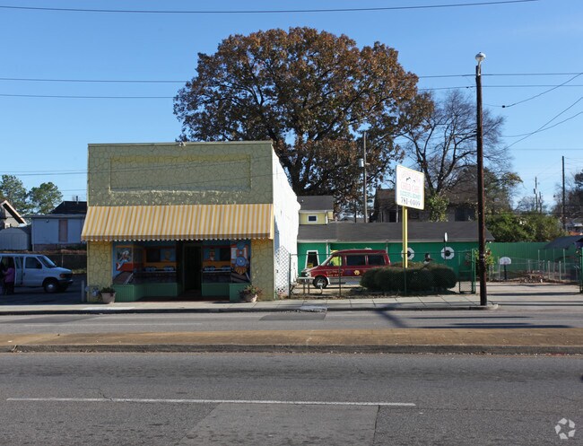
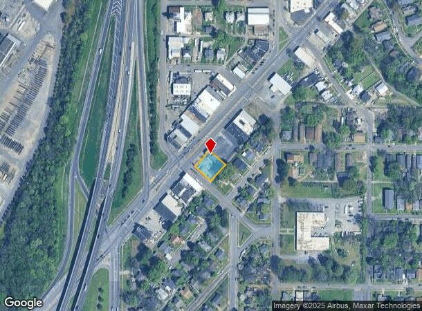
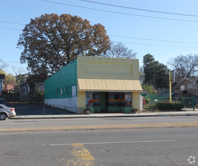
Property Record
5227 Valley Rd, Fairfield, AL 35064
NEARBY LISTINGS FOR SALE OR LEASE
Property Detail
5227 Valley Rd
Birmingham-Hoover, AL
Corey
30-00-12-3-005-006.000
LOTS 21 THRU 24 BLK 56 COREY LAND CO S 1ST SUBDIVISION OF COREY PT 9 PG 15
Publicschool
Jefferson
X
Alabama
01073C0531G
21-24
2023
0.23 AC
2024
Bessemer
010604
Birmingham
3,780 SF
DEMOGRAPHICS near 5227 Valley Rd
1 Mile
3 Mile
5 Mile
2024 Total Population
7,774
53,348
115,995
2029 Population
7,892
53,345
116,176
Pop Growth 2024-2029
+ 1.52%
(0.01%)
+ 0.16%
Average Age
38
41
41
2024 Total Households
2,855
22,087
48,665
HH Growth 2024-2029
+ 1.47%
(0.06%)
+ 0.18%
Median Household Inc
$40,913
$39,717
$38,834
Avg Household Size
2.40
2.30
2.20
2024 Avg HH Vehicles
1.00
2.00
2.00
Median Home Value
$74,319
$78,864
$91,421
Median Year Built
1955
1959
1964
Nearby Places
Map Layers
Map Styles
 Street
 Aerial
- Restaurants
- Banks
- Shops
- Fitness
- Groceries
PUBLIC TRANSPORTATION
COMMUTER RAIL
Birmingham (Crescent - Amtrak)
DRIVE
WALK
Distance
Birmingham (Crescent - Amtrak)
10 min
7.9 mi
AIRPORT
Birmingham-Shuttlesworth International
DRIVE
WALK
Distance
Birmingham-Shuttlesworth International
16 min
12.8 mi
Freight Ports
Port of Mobile
DRIVE
WALK
Distance
Port of Mobile
286 min
262.3 mi
Nearby Properties
Address
Land Use
TOTAL SIZE
Lot Size
Zoning
Address
Land Use
TOTAL SIZE
Lot Size
Zoning
1.77 AC
QO&I
Address
Land Use
TOTAL SIZE
Lot Size
Zoning
1,244,986 SF
I2
Address
Land Use
TOTAL SIZE
Lot Size
Zoning
2,573,547 SF
112 AC
I2
Address
Land Use
TOTAL SIZE
Lot Size
Zoning
127,240 SF
3.50 AC
R4
Address
Land Use
TOTAL SIZE
Lot Size
Zoning
200,650 SF
19.48 AC
R4
Address
Land Use
TOTAL SIZE
Lot Size
Zoning
116,442 SF
2.67 AC
B6
Address
Land Use
TOTAL SIZE
Lot Size
Zoning
191,664 SF
14.73 AC
R4
Address
Land Use
TOTAL SIZE
Lot Size
Zoning
288,000 SF
39.40 AC
I2-I
Address
Land Use
TOTAL SIZE
Lot Size
Zoning
250,918 SF
10 AC
B-2
Address
Land Use
TOTAL SIZE
Lot Size
Zoning
46,155 SF
0.77 AC
R4
Address
Land Use
TOTAL SIZE
Lot Size
Zoning
41,695 SF
5.40 AC
R4
Address
Land Use
TOTAL SIZE
Lot Size
Zoning
101,671 SF
14.73 AC
B2
Address
Land Use
TOTAL SIZE
Lot Size
Zoning
218,210 SF
11.24 AC
CM-2
Address
Land Use
TOTAL SIZE
Lot Size
Zoning
37,619 SF
9.36 AC
R3
Address
Land Use
TOTAL SIZE
Lot Size
Zoning
65,260 SF
5.29 AC
B2
Address
Land Use
TOTAL SIZE
Lot Size
Zoning
128,484 SF
8.70 AC
QB1
Address
Land Use
TOTAL SIZE
Lot Size
Zoning
66,935 SF
1.99 AC
B2
Address
Land Use
TOTAL SIZE
Lot Size
Zoning
157,183 SF
6.50 AC
B2
Address
Land Use
TOTAL SIZE
Lot Size
Zoning
39,347 SF
6.03 AC
B2
Address
Land Use
TOTAL SIZE
Lot Size
Zoning
65,371 SF
1.27 AC
B2
Address
Land Use
TOTAL SIZE
Lot Size
Zoning
104,775 SF
9.40 AC
B-2
Address
Land Use
TOTAL SIZE
Lot Size
Zoning
1,437,077 SF
I2
Address
Land Use
TOTAL SIZE
Lot Size
Zoning
94,026 SF
4.90 AC
I2R2
Address
Land Use
TOTAL SIZE
Lot Size
Zoning
3,644 SF
10.60 AC
CM2
Address
Land Use
TOTAL SIZE
Lot Size
Zoning
45,666 SF
3.46 AC
R5
Address
Land Use
TOTAL SIZE
Lot Size
Zoning
96,543 SF
8.80 AC
B2
Address
Land Use
TOTAL SIZE
Lot Size
Zoning
1 SF
10.67 AC
QB1
Address
Land Use
TOTAL SIZE
Lot Size
Zoning
34,509 SF
0.52 AC
R3
Address
Land Use
TOTAL SIZE
Lot Size
Zoning
95,991 SF
4.66 AC
R5
Address
Land Use
TOTAL SIZE
Lot Size
Zoning
37,793 SF
2.57 AC
R3
The World's #1 Commercial Real Estate Marketplace
Connect with us
© 2025 CoStar Group
The information above has been obtained from sources believed reliable. While we do not doubt its accuracy we have not verified it and make no guarantee, warranty or representation about it. It is your responsibility to independently confirm its accuracy and completeness. Any projections, opinions, assumptions, or estimates used are for example only and do not represent the current or future performance of the property. The value of this transaction to you depends on tax and other factors which should be evaluated by your tax, financial, and legal advisors. You and your advisors should conduct a careful, independent investigation of the property to determine to your satisfaction the suitability of the property for your needs.