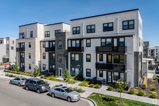
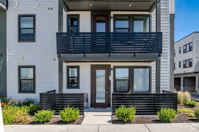
Property Record
5227 W Reventon Dr, South Jordan, UT 84009
NEARBY LISTINGS FOR SALE OR LEASE
-
-
View all South Jordan listings for sale on LoopNet.com
Property Detail
5227 W Reventon Dr
Salt Lake City
South Station Plat 3 Condo
Salt Lake City, UT
BEG S 89^5530 E 2443.844 FT & N 3922.359 FT FR SW COR OF SEC 24, T3S, R2W, SLM; N 53^2706 E 139.562 FT; S 36^3254E 151.141 FT; S 53^2706 W 68.562 FT; N 36^3254 W 85.443 FT; S 53^2706 W 11.677 FT; S 52^0002 W 44.014 FT; S 53^2706 W 5.323 FT; NWLY ALG
26-24-182-001-0000
Salt Lake
Commercialcondominium
Utah
0
0.35 AC
2025
Daybreak
115210
DEMOGRAPHICS near 5227 W Reventon Dr
1 Mile
3 Mile
5 Mile
2024 Total Population
17,609
99,659
238,124
2029 Population
18,292
101,911
242,417
Pop Growth 2024-2029
+ 3.88%
+ 2.26%
+ 1.80%
Average Age
33
33
34
2024 Total Households
5,560
29,032
68,587
HH Growth 2024-2029
+ 3.85%
+ 2.30%
+ 1.76%
Median Household Inc
$108,734
$107,328
$106,479
Avg Household Size
3.20
3.40
3.40
2024 Avg HH Vehicles
2.00
2.00
2.00
Median Home Value
$530,628
$499,519
$490,993
Median Year Built
2011
2010
2006
Nearby Places
Map Layers
Map Styles
 Street
 Aerial
- Restaurants
- Banks
- Shops
- Fitness
- Groceries
PUBLIC TRANSPORTATION
TRANSIT/SUBWAY
Daybreak Parkway Station (Red Line - Utah Transit Authority (UTA))
DRIVE
WALK
Distance
Daybreak Parkway Station (Red Line - Utah Transit Authority (UTA))
1 min
7 min
0.4 mi
COMMUTER RAIL
South Jordan Station (FrontRunner - Utah Transit Authority (UTA))
DRIVE
WALK
Distance
South Jordan Station (FrontRunner - Utah Transit Authority (UTA))
15 min
7.3 mi
Draper Station (FrontRunner - Utah Transit Authority (UTA))
DRIVE
WALK
Distance
Draper Station (FrontRunner - Utah Transit Authority (UTA))
17 min
8.6 mi
AIRPORT
Salt Lake City International
DRIVE
WALK
Distance
Salt Lake City International
27 min
19.7 mi
Provo Municipal
DRIVE
WALK
Distance
Provo Municipal
48 min
34.6 mi
Freight Ports
Port of Stockton
DRIVE
WALK
Distance
Port of Stockton
721 min
699.4 mi
Nearby Properties
Address
Land Use
TOTAL SIZE
Lot Size
Zoning
Address
Land Use
TOTAL SIZE
Lot Size
Zoning
540,554 SF
63.03 AC
C-R
Address
Land Use
TOTAL SIZE
Lot Size
Zoning
340,894 SF
60.46 AC
P-C
Address
Land Use
TOTAL SIZE
Lot Size
Zoning
1,328,525 SF
76.12 AC
A-20
Address
Land Use
TOTAL SIZE
Lot Size
Zoning
285,200 SF
55.78 AC
1210
Address
Land Use
TOTAL SIZE
Lot Size
Zoning
554,682 SF
30.25 AC
SLR-SP
Address
Land Use
TOTAL SIZE
Lot Size
Zoning
126,150 SF
25.43 AC
RM
Address
Land Use
TOTAL SIZE
Lot Size
Zoning
1,042,750 SF
55.65 AC
M-1
Address
Land Use
TOTAL SIZE
Lot Size
Zoning
591,044 SF
13.87 AC
C-2
Address
Land Use
TOTAL SIZE
Lot Size
Zoning
469,074 SF
5.14 AC
C-P
Address
Land Use
TOTAL SIZE
Lot Size
Zoning
702,100 SF
13.83 AC
P-C
Address
Land Use
TOTAL SIZE
Lot Size
Zoning
73,318 SF
1.36 AC
PC
Address
Land Use
TOTAL SIZE
Lot Size
Zoning
241,215 SF
51.07 AC
M-1
Address
Land Use
TOTAL SIZE
Lot Size
Zoning
269,342 SF
12.68 AC
MU-2
Address
Land Use
TOTAL SIZE
Lot Size
Zoning
857,680 SF
75.49 AC
M-1
Address
Land Use
TOTAL SIZE
Lot Size
Zoning
219,020 SF
93.27 AC
M-1
Address
Land Use
TOTAL SIZE
Lot Size
Zoning
609,061 SF
40 AC
M-1
Address
Land Use
TOTAL SIZE
Lot Size
Zoning
204,793 SF
53.90 AC
M-1
Address
Land Use
TOTAL SIZE
Lot Size
Zoning
323,922 SF
30.86 AC
PCC
Address
Land Use
TOTAL SIZE
Lot Size
Zoning
321,528 SF
15.77 AC
R-3-16
Address
Land Use
TOTAL SIZE
Lot Size
Zoning
137,750 SF
12.64 AC
1210
Address
Land Use
TOTAL SIZE
Lot Size
Zoning
256,933 SF
19.68 AC
P-C
Address
Land Use
TOTAL SIZE
Lot Size
Zoning
59,711 SF
4.77 AC
C-2
Address
Land Use
TOTAL SIZE
Lot Size
Zoning
425,753 SF
2.28 AC
PC
Address
Land Use
TOTAL SIZE
Lot Size
Zoning
398,447 SF
11.04 AC
BMHU
Address
Land Use
TOTAL SIZE
Lot Size
Zoning
348,043 SF
5.35 AC
PC
Address
Land Use
TOTAL SIZE
Lot Size
Zoning
100,474 SF
12.99 AC
R-M-18
Address
Land Use
TOTAL SIZE
Lot Size
Zoning
348,917 SF
6.23 AC
PC
Address
Land Use
TOTAL SIZE
Lot Size
Zoning
554,777 SF
168.76 AC
M-1
Address
Land Use
TOTAL SIZE
Lot Size
Zoning
4.76 AC
PC
Address
Land Use
TOTAL SIZE
Lot Size
Zoning
232,874 SF
7.04 AC
RM-18
The World's #1 Commercial Real Estate Marketplace
Connect with us
© 2025 CoStar Group
The information above has been obtained from sources believed reliable. While we do not doubt its accuracy we have not verified it and make no guarantee, warranty or representation about it. It is your responsibility to independently confirm its accuracy and completeness. Any projections, opinions, assumptions, or estimates used are for example only and do not represent the current or future performance of the property. The value of this transaction to you depends on tax and other factors which should be evaluated by your tax, financial, and legal advisors. You and your advisors should conduct a careful, independent investigation of the property to determine to your satisfaction the suitability of the property for your needs.