Property Record
5230 Beauchamp Ln, Winston Salem, NC 27104

NEARBY LISTINGS FOR SALE OR LEASE
Property Detail
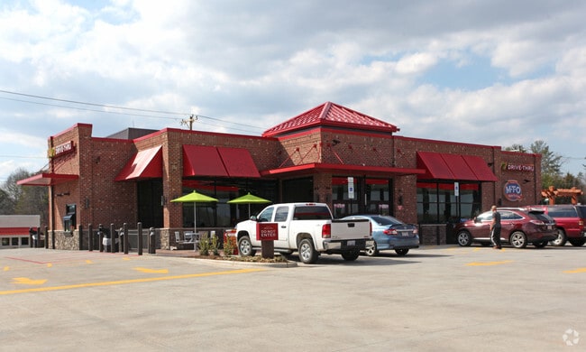
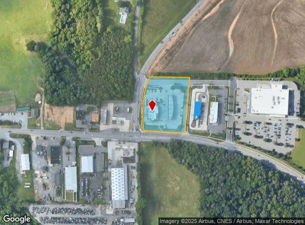
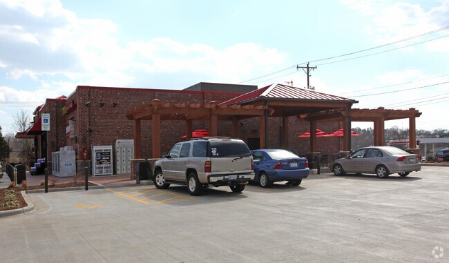
5230 Beauchamp Ln
Winston-Salem, NC
Sheetz
5895-55-3838
SHEETZ LO:001 BL:4429F BU:1
Storebuilding
Forsyth
X
North Carolina
3710589500J
1
2024
2.17 AC
2025
Western Forsyth County
004010
Greensboro/Winston-Salem
5,886 SF
DEMOGRAPHICS near 5230 Beauchamp Ln
1 Mile
3 Mile
5 Mile
2024 Total Population
5,805
45,276
105,138
2029 Population
6,101
47,090
109,233
Pop Growth 2024-2029
+ 5.10%
+ 4.01%
+ 3.89%
Average Age
41
41
42
2024 Total Households
2,552
19,409
44,359
HH Growth 2024-2029
+ 4.94%
+ 3.99%
+ 3.89%
Median Household Inc
$95,486
$81,136
$81,538
Avg Household Size
2.30
2.30
2.30
2024 Avg HH Vehicles
2.00
2.00
2.00
Median Home Value
$311,420
$298,781
$283,574
Median Year Built
1992
1987
1985
Nearby Places
Map Layers
Map Styles
 Street
 Aerial
- Restaurants
- Banks
- Shops
- Fitness
- Groceries
PUBLIC TRANSPORTATION
AIRPORT
Piedmont Triad International
DRIVE
WALK
Distance
Piedmont Triad International
45 min
30.9 mi
Freight Ports
Virginia Port Authority - Richmond
DRIVE
WALK
Distance
Virginia Port Authority - Richmond
272 min
234.5 mi
Nearby Properties
Address
Land Use
TOTAL SIZE
Lot Size
Zoning
Address
Land Use
TOTAL SIZE
Lot Size
Zoning
124,972 SF
19.32 AC
MU-S
Address
Land Use
TOTAL SIZE
Lot Size
Zoning
128,592 SF
28.33 AC
GB-S
Address
Land Use
TOTAL SIZE
Lot Size
Zoning
297,487 SF
40.24 AC
RM12,RM18
Address
Land Use
TOTAL SIZE
Lot Size
Zoning
95,995 SF
31.49 AC
RM12,RM18
Address
Land Use
TOTAL SIZE
Lot Size
Zoning
61,125 SF
8.66 AC
MU-S
Address
Land Use
TOTAL SIZE
Lot Size
Zoning
125,015 SF
33.69 AC
LO-S,RM8-S
Address
Land Use
TOTAL SIZE
Lot Size
Zoning
275,051 SF
32.47 AC
PB-S,RM18
Address
Land Use
TOTAL SIZE
Lot Size
Zoning
257,080 SF
23.47 AC
HB-S
Address
Land Use
TOTAL SIZE
Lot Size
Zoning
189,737 SF
20.53 AC
CD1-S
Address
Land Use
TOTAL SIZE
Lot Size
Zoning
115,352 SF
11.21 AC
RM8-S
Address
Land Use
TOTAL SIZE
Lot Size
Zoning
200,651 SF
60 AC
IP
Address
Land Use
TOTAL SIZE
Lot Size
Zoning
68,118 SF
12.74 AC
MU-S
Address
Land Use
TOTAL SIZE
Lot Size
Zoning
179,142 SF
42.52 AC
RS9
Address
Land Use
TOTAL SIZE
Lot Size
Zoning
402,885 SF
19.63 AC
HB-S
Address
Land Use
TOTAL SIZE
Lot Size
Zoning
73,930 SF
18 AC
RM12-S
Address
Land Use
TOTAL SIZE
Lot Size
Zoning
113,351 SF
11.87 AC
MU-S
Address
Land Use
TOTAL SIZE
Lot Size
Zoning
64,236 SF
14.71 AC
RM12-S
Address
Land Use
TOTAL SIZE
Lot Size
Zoning
62,546 SF
4.63 AC
LO-S
Address
Land Use
TOTAL SIZE
Lot Size
Zoning
80,319 SF
14.77 AC
RM12,RM18-
Address
Land Use
TOTAL SIZE
Lot Size
Zoning
68,153 SF
8.60 AC
GB-S
Address
Land Use
TOTAL SIZE
Lot Size
Zoning
56,638 SF
16.54 AC
RM8-S
Address
Land Use
TOTAL SIZE
Lot Size
Zoning
89,801 SF
9.50 AC
PB-S
Address
Land Use
TOTAL SIZE
Lot Size
Zoning
75,507 SF
12.46 AC
RM18
Address
Land Use
TOTAL SIZE
Lot Size
Zoning
45,427 SF
17.84 AC
RM8-S
Address
Land Use
TOTAL SIZE
Lot Size
Zoning
96,996 SF
6.51 AC
RMU-S,RS9
Address
Land Use
TOTAL SIZE
Lot Size
Zoning
93,647 SF
14.35 AC
RM18
Address
Land Use
TOTAL SIZE
Lot Size
Zoning
100,044 SF
7.93 AC
HB,HB-S
Address
Land Use
TOTAL SIZE
Lot Size
Zoning
79,327 SF
22.97 AC
RS9
Address
Land Use
TOTAL SIZE
Lot Size
Zoning
74,416 SF
9.47 AC
RM8-S
Address
Land Use
TOTAL SIZE
Lot Size
Zoning
40,111 SF
3.42 AC
GB-S
The World's #1 Commercial Real Estate Marketplace
Connect with us
© 2026 CoStar Group
The information above has been obtained from sources believed reliable. While we do not doubt its accuracy we have not verified it and make no guarantee, warranty or representation about it. It is your responsibility to independently confirm its accuracy and completeness. Any projections, opinions, assumptions, or estimates used are for example only and do not represent the current or future performance of the property. The value of this transaction to you depends on tax and other factors which should be evaluated by your tax, financial, and legal advisors. You and your advisors should conduct a careful, independent investigation of the property to determine to your satisfaction the suitability of the property for your needs.