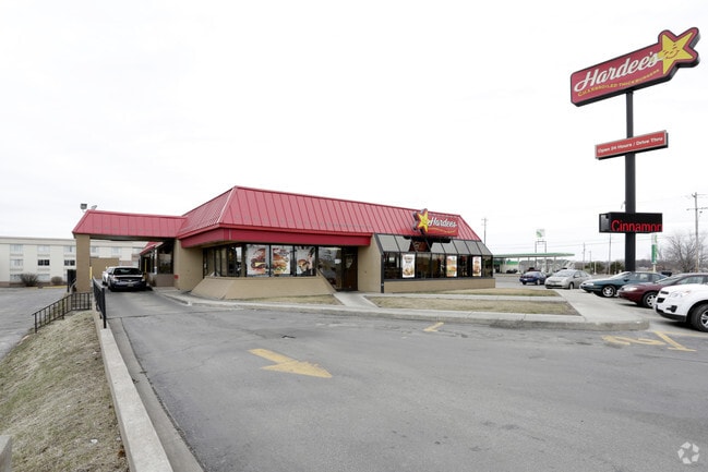
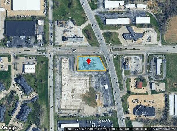
Property Record
5230 N Brady St, Davenport, IA 52806

NEARBY LISTINGS FOR SALE OR LEASE
Property Detail
5230 N Brady St
Davenport-Moline-Rock Island, IA-IL
Langer Outlots
P1209-05A
LANGER OUTLOTS LOT: 008 LANGER OUTLOTSPRT LOT 8 COM NW CORSW/4 SEC 12; -S 50';-E 226.84' TO POB; -S 154.62'; -E 291.9'; -N
Restaurantdrivein
Scott
X
Iowa
19163C0355H
8
2025
0.85 AC
2025
Greater Davenport
012802
Davenport/Moline/Rock Island
4,106 SF
DEMOGRAPHICS near 5230 N Brady St
1 Mile
3 Mile
5 Mile
2024 Total Population
6,270
66,292
133,492
2029 Population
6,306
65,909
132,867
Pop Growth 2024-2029
+ 0.57%
(0.58%)
(0.47%)
Average Age
38
39
39
2024 Total Households
2,677
27,421
55,728
HH Growth 2024-2029
+ 0.37%
(0.67%)
(0.48%)
Median Household Inc
$52,385
$59,094
$58,887
Avg Household Size
2.20
2.30
2.30
2024 Avg HH Vehicles
2.00
2.00
2.00
Median Home Value
$158,778
$167,410
$170,752
Median Year Built
1983
1970
1968
Nearby Places
Map Layers
Map Styles
 Street
 Aerial
- Restaurants
- Banks
- Shops
- Fitness
- Groceries
PUBLIC TRANSPORTATION
AIRPORT
Quad Cities International
DRIVE
WALK
Distance
Quad Cities International
19 min
12.4 mi
Nearby Properties
Address
Land Use
TOTAL SIZE
Lot Size
Zoning
Address
Land Use
TOTAL SIZE
Lot Size
Zoning
7,934 SF
8.41 AC
Address
Land Use
TOTAL SIZE
Lot Size
Zoning
2,615,134 SF
120.68 AC
Address
Land Use
TOTAL SIZE
Lot Size
Zoning
3,516 SF
26.74 AC
Address
Land Use
TOTAL SIZE
Lot Size
Zoning
157,587 SF
33.92 AC
Address
Land Use
TOTAL SIZE
Lot Size
Zoning
92,431 SF
40.01 AC
Address
Land Use
TOTAL SIZE
Lot Size
Zoning
253,608 SF
9.29 AC
Address
Land Use
TOTAL SIZE
Lot Size
Zoning
128,100 SF
14.65 AC
Address
Land Use
TOTAL SIZE
Lot Size
Zoning
45,602 SF
149.61 AC
Address
Land Use
TOTAL SIZE
Lot Size
Zoning
27,225 SF
40.34 AC
Address
Land Use
TOTAL SIZE
Lot Size
Zoning
27,306 SF
50.57 AC
Address
Land Use
TOTAL SIZE
Lot Size
Zoning
300,718 SF
14.71 AC
Address
Land Use
TOTAL SIZE
Lot Size
Zoning
63,359 SF
12.01 AC
Address
Land Use
TOTAL SIZE
Lot Size
Zoning
472,569 SF
47.24 AC
Address
Land Use
TOTAL SIZE
Lot Size
Zoning
12,500 SF
578.76 AC
Address
Land Use
TOTAL SIZE
Lot Size
Zoning
123,823 SF
6.46 AC
Address
Land Use
TOTAL SIZE
Lot Size
Zoning
4,944 SF
17.91 AC
Address
Land Use
TOTAL SIZE
Lot Size
Zoning
4,804 SF
202 AC
Address
Land Use
TOTAL SIZE
Lot Size
Zoning
25,176 SF
13.85 AC
Address
Land Use
TOTAL SIZE
Lot Size
Zoning
26,472 SF
17.67 AC
Address
Land Use
TOTAL SIZE
Lot Size
Zoning
77,187 SF
0.88 AC
Address
Land Use
TOTAL SIZE
Lot Size
Zoning
27,312 SF
15.04 AC
Address
Land Use
TOTAL SIZE
Lot Size
Zoning
70,098 SF
9.72 AC
Address
Land Use
TOTAL SIZE
Lot Size
Zoning
8,000 SF
4.59 AC
Address
Land Use
TOTAL SIZE
Lot Size
Zoning
156,632 SF
17.67 AC
Address
Land Use
TOTAL SIZE
Lot Size
Zoning
71,820 SF
5.71 AC
Address
Land Use
TOTAL SIZE
Lot Size
Zoning
197,946 SF
18.64 AC
Address
Land Use
TOTAL SIZE
Lot Size
Zoning
4,800 SF
18.86 AC
Address
Land Use
TOTAL SIZE
Lot Size
Zoning
84,002 SF
21.76 AC
Address
Land Use
TOTAL SIZE
Lot Size
Zoning
4,958 SF
15.49 AC
Address
Land Use
TOTAL SIZE
Lot Size
Zoning
115,968 SF
2.93 AC
The World's #1 Commercial Real Estate Marketplace
Connect with us
© 2025 CoStar Group
The information above has been obtained from sources believed reliable. While we do not doubt its accuracy we have not verified it and make no guarantee, warranty or representation about it. It is your responsibility to independently confirm its accuracy and completeness. Any projections, opinions, assumptions, or estimates used are for example only and do not represent the current or future performance of the property. The value of this transaction to you depends on tax and other factors which should be evaluated by your tax, financial, and legal advisors. You and your advisors should conduct a careful, independent investigation of the property to determine to your satisfaction the suitability of the property for your needs.