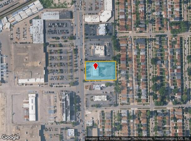
Property Record
5231 S Pulaski Rd, Chicago, IL 60632
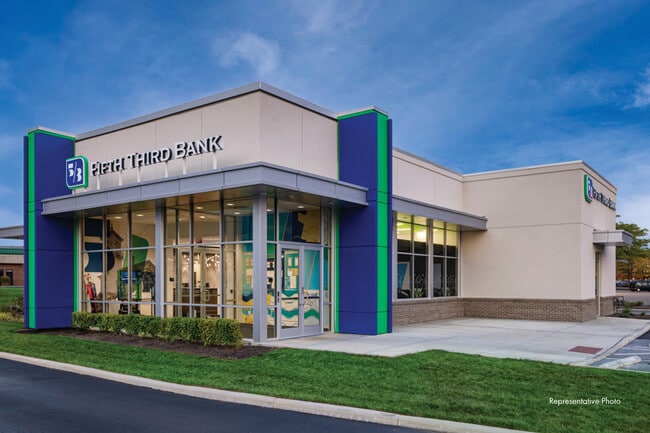

This Property Is For Sale
NEARBY LISTINGS FOR SALE OR LEASE
Property Detail
5231 S Pulaski Rd
19-11-300-010-0000
Lynnwood Subdivision Unit #1
Financialbuilding
Cook
X
Illinois
17031C0515J
1.14 AC
2023
South Chicago
2024
Chicago
620100
Chicago-Naperville-Elgin, IL-IN-WI
4,300 SF
DEMOGRAPHICS near 5231 S Pulaski Rd
1 Mile
3 Mile
5 Mile
2024 Total Population
35,329
244,372
656,616
2029 Population
32,807
226,730
615,394
Pop Growth 2024-2029
(7.14%)
(7.22%)
(6.28%)
Average Age
36
36
37
2024 Total Households
9,812
70,795
209,616
HH Growth 2024-2029
(7.58%)
(7.64%)
(6.57%)
Median Household Inc
$56,325
$48,747
$50,759
Avg Household Size
3.50
3.30
3.00
2024 Avg HH Vehicles
2.00
2.00
1.00
Median Home Value
$220,345
$215,141
$221,538
Median Year Built
1952
1950
1949
Nearby Places
- Restaurants
- Banks
- Shops
- Fitness
- Groceries
PUBLIC TRANSPORTATION
TRANSIT/SUBWAY
Pulaski Station (Orange Line) (Orange Line - Chicago Transit Authority "L" Trains (The "L"))
DRIVE
WALK
Distance
Pulaski Station (Orange Line) (Orange Line - Chicago Transit Authority "L" Trains (The "L"))
1 min
6 min
0.3 mi
COMMUTER RAIL
Wrightwood Station (SouthWest Service - Northeast Illinois Regional Commuter Railroad (Metra))
DRIVE
WALK
Distance
Wrightwood Station (SouthWest Service - Northeast Illinois Regional Commuter Railroad (Metra))
8 min
4.4 mi
Cicero Station (Burlington Northern-Santa Fe Railway Line - Northeast Illinois Regional Commuter Railroad (Metra))
DRIVE
WALK
Distance
Cicero Station (Burlington Northern-Santa Fe Railway Line - Northeast Illinois Regional Commuter Railroad (Metra))
9 min
4.5 mi
AIRPORT
Chicago Midway International
DRIVE
WALK
Distance
Chicago Midway International
4 min
1.9 mi
Chicago O'Hare International
DRIVE
WALK
Distance
Chicago O'Hare International
37 min
21.1 mi
Freight Ports
Port Milwaukee
DRIVE
WALK
Distance
Port Milwaukee
115 min
89.3 mi
Nearby Properties
Address
Land Use
TOTAL SIZE
Lot Size
Zoning
Address
Land Use
TOTAL SIZE
Lot Size
Zoning
4.71 AC
PD 1196
Address
Land Use
TOTAL SIZE
Lot Size
Zoning
2.98 AC
PD 1196
Address
Land Use
TOTAL SIZE
Lot Size
Zoning
134,800 SF
2.53 AC
PD 1273
Address
Land Use
TOTAL SIZE
Lot Size
Zoning
1,269,112 SF
39.99 AC
M2-1
Address
Land Use
TOTAL SIZE
Lot Size
Zoning
604,145 SF
28.21 AC
Address
Land Use
TOTAL SIZE
Lot Size
Zoning
2,155,128 SF
63.23 AC
PMD13
Address
Land Use
TOTAL SIZE
Lot Size
Zoning
27.31 AC
PD 1424
Address
Land Use
TOTAL SIZE
Lot Size
Zoning
798,998 SF
B3-2
Address
Land Use
TOTAL SIZE
Lot Size
Zoning
133,354 SF
PD 1198
Address
Land Use
TOTAL SIZE
Lot Size
Zoning
290,798 SF
23.70 AC
Address
Land Use
TOTAL SIZE
Lot Size
Zoning
124,324 SF
11.26 AC
Address
Land Use
TOTAL SIZE
Lot Size
Zoning
4.83 AC
Address
Land Use
TOTAL SIZE
Lot Size
Zoning
0.84 AC
B1-3
Address
Land Use
TOTAL SIZE
Lot Size
Zoning
633,057 SF
34.96 AC
PMD 8
Address
Land Use
TOTAL SIZE
Lot Size
Zoning
796,454 SF
25.68 AC
PMD13
Address
Land Use
TOTAL SIZE
Lot Size
Zoning
1,615,006 SF
41.91 AC
PMD13
Address
Land Use
TOTAL SIZE
Lot Size
Zoning
189,197 SF
23.08 AC
Address
Land Use
TOTAL SIZE
Lot Size
Zoning
1,023,467 SF
21.45 AC
PD 1424
Address
Land Use
TOTAL SIZE
Lot Size
Zoning
57,366 SF
10 AC
Address
Land Use
TOTAL SIZE
Lot Size
Zoning
1,107,999 SF
119.41 AC
Address
Land Use
TOTAL SIZE
Lot Size
Zoning
131,261 SF
7.04 AC
PD 172
Address
Land Use
TOTAL SIZE
Lot Size
Zoning
151,303 SF
0.88 AC
PD 568
Address
Land Use
TOTAL SIZE
Lot Size
Zoning
134,078 SF
17.31 AC
Address
Land Use
TOTAL SIZE
Lot Size
Zoning
PD 610
Address
Land Use
TOTAL SIZE
Lot Size
Zoning
310,775 SF
12.46 AC
M2-3
Address
Land Use
TOTAL SIZE
Lot Size
Zoning
102,534 SF
3.87 AC
Address
Land Use
TOTAL SIZE
Lot Size
Zoning
148,474 SF
17.68 AC
Address
Land Use
TOTAL SIZE
Lot Size
Zoning
93,438 SF
3.13 AC
Address
Land Use
TOTAL SIZE
Lot Size
Zoning
86,703 SF
3.37 AC
Address
Land Use
TOTAL SIZE
Lot Size
Zoning
3.06 AC
The World's #1 Commercial Real Estate Marketplace
Connect with us
© 2025 CoStar Group
The information above has been obtained from sources believed reliable. While we do not doubt its accuracy we have not verified it and make no guarantee, warranty or representation about it. It is your responsibility to independently confirm its accuracy and completeness. Any projections, opinions, assumptions, or estimates used are for example only and do not represent the current or future performance of the property. The value of this transaction to you depends on tax and other factors which should be evaluated by your tax, financial, and legal advisors. You and your advisors should conduct a careful, independent investigation of the property to determine to your satisfaction the suitability of the property for your needs.