Property Record
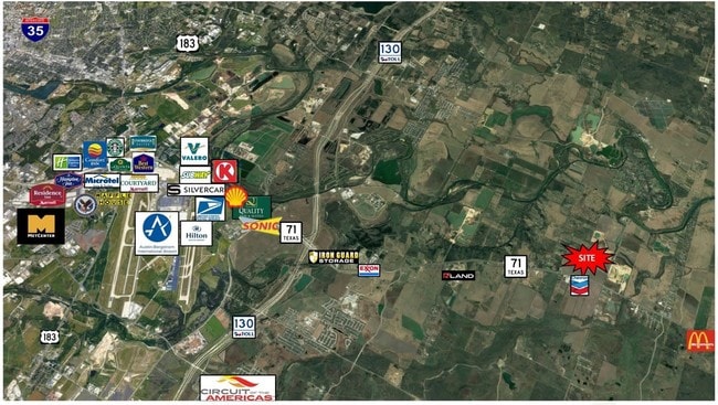
5235 Highway 71 E, Del Valle, TX 78617

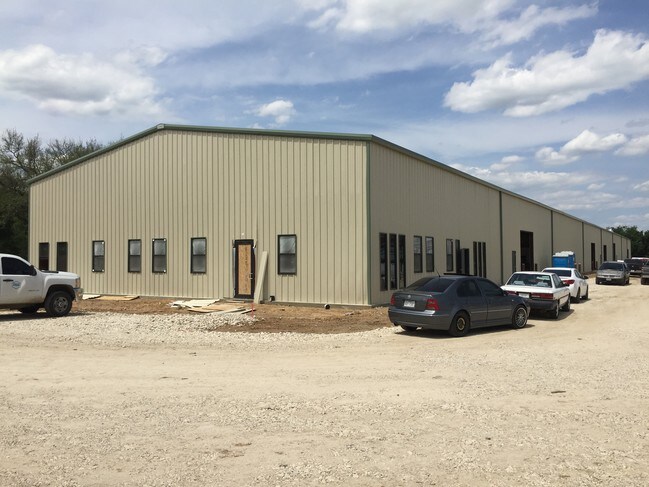
Property Detail
5235 Highway 71 E
295969
ABS 18 NAVARRO J A ACR 12.4800
Industrialgeneral
Travis
B and X Area of moderate flood hazard, usually the area between the limits of the 100-year and 500-year floods.
Texas
2025
12.48 AC
2025
Southeast
002453
Austin
90,251 SF
Austin-Round Rock-San Marcos, TX
NEARBY LISTINGS FOR SALE OR LEASE
DEMOGRAPHICS near 5235 Highway 71 E
1 mile
3 mile
5 mile
2025 Total Population
313
2,437
29,218
2030 Population
328
2,582
31,247
Pop Growth 2025-2030
+ 4.79%
+ 5.95%
+ 6.94%
Average Age
39
40
36
2025 Total Households
97
794
8,871
HH Growth 2025-2030
+ 5.15%
+ 6.68%
+ 7.67%
Median Household Inc
$74,582
$78,241
$89,219
Avg Household Size
3.00
2.90
3.20
2025 Avg HH Vehicles
2.00
2.00
2.00
Median Home Value
$75,581
$91,176
$320,612
Median Year Built
1983
1986
2008
Nearby Places
Map Layers
Map Styles
 Street
 Aerial
Transit
 Traffic
 Biking
Places
Listings with unknown addresses are not visible on the map
- Restaurants
- Banks
- Shops
- Fitness
- Groceries
PUBLIC TRANSPORTATION
AIRPORT
Austin-Bergstrom International
Drive
Walk
Distance
Austin-Bergstrom International
21 min
10.8 mi
Freight Ports
Calhoun Port
Drive
Walk
Distance
Calhoun Port
181 min
153.7 mi
SALE & LEASE HISTORY
LISTING DATE
SALE/LEASE

Mar 05, 2018
For Sale
Jul 12, 2017
For Lease
Nearby Properties
Address
Land Use
TOTAL SIZE
Lot Size
Zoning
Address
Land Use
TOTAL SIZE
Lot Size
Zoning
1 SF
120 AC
Address
Land Use
TOTAL SIZE
Lot Size
Zoning
215,912 SF
40.94 AC
Address
Land Use
TOTAL SIZE
Lot Size
Zoning
550 SF
31.23 AC
Address
Land Use
TOTAL SIZE
Lot Size
Zoning
238.94 AC
Address
Land Use
TOTAL SIZE
Lot Size
Zoning
18,248 SF
36.47 AC
Address
Land Use
TOTAL SIZE
Lot Size
Zoning
784 SF
316.76 AC
Address
Land Use
TOTAL SIZE
Lot Size
Zoning
7,653 SF
36.99 AC
Address
Land Use
TOTAL SIZE
Lot Size
Zoning
43.26 AC
Address
Land Use
TOTAL SIZE
Lot Size
Zoning
19,968 SF
0.58 AC
Address
Land Use
TOTAL SIZE
Lot Size
Zoning
48,254 SF
9.42 AC
Address
Land Use
TOTAL SIZE
Lot Size
Zoning
6,633 SF
18.82 AC
Address
Land Use
TOTAL SIZE
Lot Size
Zoning
139.67 AC
Address
Land Use
TOTAL SIZE
Lot Size
Zoning
113.55 AC
Address
Land Use
TOTAL SIZE
Lot Size
Zoning
54,640 SF
6.40 AC
Address
Land Use
TOTAL SIZE
Lot Size
Zoning
104.29 AC
Address
Land Use
TOTAL SIZE
Lot Size
Zoning
900 SF
425.40 AC
Address
Land Use
TOTAL SIZE
Lot Size
Zoning
119.06 AC
Address
Land Use
TOTAL SIZE
Lot Size
Zoning
10,232 SF
278.51 AC
Address
Land Use
TOTAL SIZE
Lot Size
Zoning
3,192 SF
86.06 AC
Address
Land Use
TOTAL SIZE
Lot Size
Zoning
10,420 SF
3.73 AC
Address
Land Use
TOTAL SIZE
Lot Size
Zoning
Address
Land Use
TOTAL SIZE
Lot Size
Zoning
12,454 SF
2 AC
Address
Land Use
TOTAL SIZE
Lot Size
Zoning
1,823 SF
55.07 AC
Address
Land Use
TOTAL SIZE
Lot Size
Zoning
9,980 SF
10.77 AC
Address
Land Use
TOTAL SIZE
Lot Size
Zoning
17.17 AC
Address
Land Use
TOTAL SIZE
Lot Size
Zoning
39.40 AC
Address
Land Use
TOTAL SIZE
Lot Size
Zoning
1,353 SF
130.36 AC
Address
Land Use
TOTAL SIZE
Lot Size
Zoning
1,024 SF
37 AC
The World's #1 Commercial Real Estate Marketplace
Connect with us
© 2026 CoStar Group
The information above has been obtained from sources believed reliable. While we do not doubt its accuracy we have not verified it and make no guarantee, warranty or representation about it. It is your responsibility to independently confirm its accuracy and completeness. Any projections, opinions, assumptions, or estimates used are for example only and do not represent the current or future performance of the property. The value of this transaction to you depends on tax and other factors which should be evaluated by your tax, financial, and legal advisors. You and your advisors should conduct a careful, independent investigation of the property to determine to your satisfaction the suitability of the property for your needs.