Property Record
Ogeechee Rd, Savannah, GA 31405
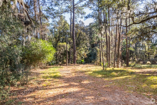
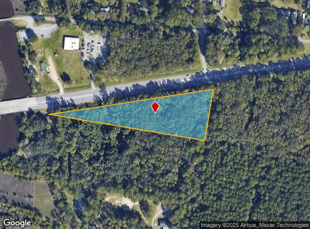

This Property Is For Sale
NEARBY LISTINGS FOR SALE OR LEASE
Property Detail
Ogeechee Rd
Savannah, GA
PORTIONS OF LOTS 37-39 SECTION 3 SILK HOPE BK 50 PG 443
60990D01006
Chatham
Vacantlandnec
Georgia
AE
37-39
13051C0140G
4.02 AC
2024
Outlying Chatham County
2025
Savannah
004500
DEMOGRAPHICS near Ogeechee Rd
1 Mile
3 Mile
5 Mile
2024 Total Population
1,257
22,657
73,270
2029 Population
1,320
23,711
76,288
Pop Growth 2024-2029
+ 5.01%
+ 4.65%
+ 4.12%
Average Age
40
38
38
2024 Total Households
499
9,047
28,603
HH Growth 2024-2029
+ 5.41%
+ 5.02%
+ 4.33%
Median Household Inc
$70,833
$67,477
$59,734
Avg Household Size
2.50
2.40
2.40
2024 Avg HH Vehicles
2.00
2.00
2.00
Median Home Value
$139,215
$216,009
$191,100
Median Year Built
1997
2003
1997
Nearby Places
Map Layers
Map Styles
 Street
 Aerial
- Restaurants
- Banks
- Shops
- Fitness
- Groceries
PUBLIC TRANSPORTATION
COMMUTER RAIL
Savannah (Palmetto - Amtrak, Silver Meteor - Amtrak, Silver Star - Amtrak)
DRIVE
WALK
Distance
Savannah (Palmetto - Amtrak, Silver Meteor - Amtrak, Silver Star - Amtrak)
11 min
5.5 mi
AIRPORT
Savannah/Hilton Head International
DRIVE
WALK
Distance
Savannah/Hilton Head International
16 min
7.4 mi
Freight Ports
Georgia Ports - Savannah
DRIVE
WALK
Distance
Georgia Ports - Savannah
17 min
8.7 mi
Nearby Properties
Address
Land Use
TOTAL SIZE
Lot Size
Zoning
Address
Land Use
TOTAL SIZE
Lot Size
Zoning
99.50 AC
M
Address
Land Use
TOTAL SIZE
Lot Size
Zoning
226,440 SF
270.14 AC
I-1
Address
Land Use
TOTAL SIZE
Lot Size
Zoning
17,400 SF
19.34 AC
Address
Land Use
TOTAL SIZE
Lot Size
Zoning
70.49 AC
M
Address
Land Use
TOTAL SIZE
Lot Size
Zoning
942,210 SF
50.60 AC
Address
Land Use
TOTAL SIZE
Lot Size
Zoning
3,515 SF
61.21 AC
I1
Address
Land Use
TOTAL SIZE
Lot Size
Zoning
691,228 SF
48.27 AC
I-1
Address
Land Use
TOTAL SIZE
Lot Size
Zoning
489,483 SF
35 AC
PUDB
Address
Land Use
TOTAL SIZE
Lot Size
Zoning
670,800 SF
43.38 AC
I-H
Address
Land Use
TOTAL SIZE
Lot Size
Zoning
34,224 SF
20 AC
C-1
Address
Land Use
TOTAL SIZE
Lot Size
Zoning
34,980 SF
23.34 AC
PR3-16
Address
Land Use
TOTAL SIZE
Lot Size
Zoning
21,316 SF
26.07 AC
PUDM18
Address
Land Use
TOTAL SIZE
Lot Size
Zoning
33,510 SF
22.30 AC
PRM16
Address
Land Use
TOTAL SIZE
Lot Size
Zoning
32,190 SF
22.11 AC
PUDBR
Address
Land Use
TOTAL SIZE
Lot Size
Zoning
12,560 SF
14.82 AC
PUD
Address
Land Use
TOTAL SIZE
Lot Size
Zoning
29,304 SF
27.20 AC
R3
Address
Land Use
TOTAL SIZE
Lot Size
Zoning
21.13 AC
PUDC
Address
Land Use
TOTAL SIZE
Lot Size
Zoning
6,580 SF
42.03 AC
PUDM-12
Address
Land Use
TOTAL SIZE
Lot Size
Zoning
413,230 SF
39.64 AC
M-CO
Address
Land Use
TOTAL SIZE
Lot Size
Zoning
26,124 SF
12 AC
BC1
Address
Land Use
TOTAL SIZE
Lot Size
Zoning
355,570 SF
25.41 AC
PIL
Address
Land Use
TOTAL SIZE
Lot Size
Zoning
500 SF
24.13 AC
I-1
Address
Land Use
TOTAL SIZE
Lot Size
Zoning
12,560 SF
22.94 AC
PUD
Address
Land Use
TOTAL SIZE
Lot Size
Zoning
31,710 SF
15.91 AC
PUDBR
Address
Land Use
TOTAL SIZE
Lot Size
Zoning
3,848 SF
9.14 AC
PBG
Address
Land Use
TOTAL SIZE
Lot Size
Zoning
200,200 SF
12.97 AC
I-1
Address
Land Use
TOTAL SIZE
Lot Size
Zoning
73,992 SF
11.89 AC
PUDBR
Address
Land Use
TOTAL SIZE
Lot Size
Zoning
97,200 SF
30.77 AC
PUDBR
Address
Land Use
TOTAL SIZE
Lot Size
Zoning
28.95 AC
M
Address
Land Use
TOTAL SIZE
Lot Size
Zoning
79.49 AC
I-H
The World's #1 Commercial Real Estate Marketplace
Connect with us
© 2025 CoStar Group
The information above has been obtained from sources believed reliable. While we do not doubt its accuracy we have not verified it and make no guarantee, warranty or representation about it. It is your responsibility to independently confirm its accuracy and completeness. Any projections, opinions, assumptions, or estimates used are for example only and do not represent the current or future performance of the property. The value of this transaction to you depends on tax and other factors which should be evaluated by your tax, financial, and legal advisors. You and your advisors should conduct a careful, independent investigation of the property to determine to your satisfaction the suitability of the property for your needs.