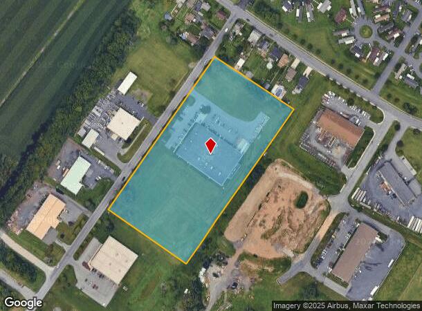
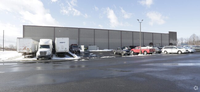
Property Record
5235 W Coplay Rd, Whitehall, PA 18052

NEARBY LISTINGS FOR SALE OR LEASE
-
-
No Photo
-
-
-
-
-
-
View all Whitehall listings for sale on LoopNet.com
Property Detail
5235 W Coplay Rd
549917702792-1
LOTS: 004
Manufacturinglight
Lehigh
X
Pennsylvania
42095C0217E
4
2025
7.55 AC
2025
Lehigh Valley
005601
Philadelphia
39,641 SF
Allentown-Bethlehem-Easton, PA-NJ
DEMOGRAPHICS near 5235 W Coplay Rd
1 Mile
3 Mile
5 Mile
2024 Total Population
10,764
47,943
120,996
2029 Population
10,817
48,190
121,678
Pop Growth 2024-2029
+ 0.49%
+ 0.52%
+ 0.56%
Average Age
42
42
40
2024 Total Households
4,517
19,467
46,166
HH Growth 2024-2029
+ 0.46%
+ 0.50%
+ 0.55%
Median Household Inc
$65,174
$71,687
$64,512
Avg Household Size
2.40
2.40
2.50
2024 Avg HH Vehicles
2.00
2.00
2.00
Median Home Value
$205,423
$223,443
$224,618
Median Year Built
1951
1965
1962
Nearby Places
Map Layers
Map Styles
 Street
 Aerial
- Restaurants
- Banks
- Shops
- Fitness
- Groceries
PUBLIC TRANSPORTATION
AIRPORT
Lehigh Valley International
DRIVE
WALK
Distance
Lehigh Valley International
16 min
6.0 mi
Freight Ports
Port of Philadelphia
DRIVE
WALK
Distance
Port of Philadelphia
91 min
67.3 mi
Nearby Properties
Address
Land Use
TOTAL SIZE
Lot Size
Zoning
Address
Land Use
TOTAL SIZE
Lot Size
Zoning
230,853 SF
96.66 AC
R-3
Address
Land Use
TOTAL SIZE
Lot Size
Zoning
453,600 SF
32.57 AC
PIO
Address
Land Use
TOTAL SIZE
Lot Size
Zoning
175,714 SF
46.35 AC
R-3
Address
Land Use
TOTAL SIZE
Lot Size
Zoning
1,046,625 SF
69.55 AC
RS
Address
Land Use
TOTAL SIZE
Lot Size
Zoning
956,444 SF
I
Address
Land Use
TOTAL SIZE
Lot Size
Zoning
504,475 SF
39.36 AC
I
Address
Land Use
TOTAL SIZE
Lot Size
Zoning
85.20 AC
I2
Address
Land Use
TOTAL SIZE
Lot Size
Zoning
260,803 SF
36.23 AC
C-2
Address
Land Use
TOTAL SIZE
Lot Size
Zoning
1,050,392 SF
218.15 AC
RS
Address
Land Use
TOTAL SIZE
Lot Size
Zoning
123,432 SF
30.70 AC
C-2
Address
Land Use
TOTAL SIZE
Lot Size
Zoning
605,893 SF
I
Address
Land Use
TOTAL SIZE
Lot Size
Zoning
29,035 SF
33.70 AC
C-2
Address
Land Use
TOTAL SIZE
Lot Size
Zoning
60,052 SF
23.96 AC
C-2
Address
Land Use
TOTAL SIZE
Lot Size
Zoning
50,343 SF
10 AC
R-3A
Address
Land Use
TOTAL SIZE
Lot Size
Zoning
45,176 SF
11.04 AC
R-4
Address
Land Use
TOTAL SIZE
Lot Size
Zoning
95,776 SF
23.70 AC
INS
Address
Land Use
TOTAL SIZE
Lot Size
Zoning
185,794 SF
30.91 AC
C-2
Address
Land Use
TOTAL SIZE
Lot Size
Zoning
96,999 SF
19.37 AC
INS
Address
Land Use
TOTAL SIZE
Lot Size
Zoning
105,219 SF
47.10 AC
RA
Address
Land Use
TOTAL SIZE
Lot Size
Zoning
164,816 SF
48.85 AC
R1
Address
Land Use
TOTAL SIZE
Lot Size
Zoning
292,700 SF
21.68 AC
RS
Address
Land Use
TOTAL SIZE
Lot Size
Zoning
51,148 SF
7 AC
R-4
Address
Land Use
TOTAL SIZE
Lot Size
Zoning
316,786 SF
29.22 AC
I2
Address
Land Use
TOTAL SIZE
Lot Size
Zoning
137,317 SF
14.25 AC
C-2
Address
Land Use
TOTAL SIZE
Lot Size
Zoning
262,476 SF
30.77 AC
I2
Address
Land Use
TOTAL SIZE
Lot Size
Zoning
111,371 SF
9.71 AC
C-2
Address
Land Use
TOTAL SIZE
Lot Size
Zoning
107,414 SF
4.20 AC
I
Address
Land Use
TOTAL SIZE
Lot Size
Zoning
15,624 SF
6.09 AC
R3
Address
Land Use
TOTAL SIZE
Lot Size
Zoning
65,524 SF
22.48 AC
I
Address
Land Use
TOTAL SIZE
Lot Size
Zoning
21,976 SF
5.40 AC
C-1
The World's #1 Commercial Real Estate Marketplace
Connect with us
© 2026 CoStar Group
The information above has been obtained from sources believed reliable. While we do not doubt its accuracy we have not verified it and make no guarantee, warranty or representation about it. It is your responsibility to independently confirm its accuracy and completeness. Any projections, opinions, assumptions, or estimates used are for example only and do not represent the current or future performance of the property. The value of this transaction to you depends on tax and other factors which should be evaluated by your tax, financial, and legal advisors. You and your advisors should conduct a careful, independent investigation of the property to determine to your satisfaction the suitability of the property for your needs.