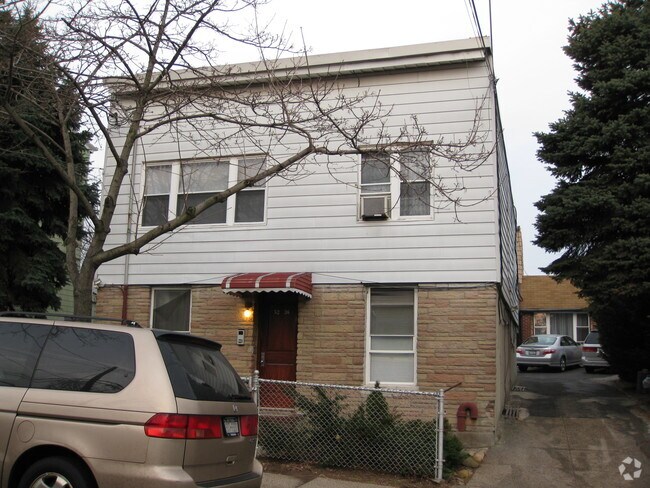
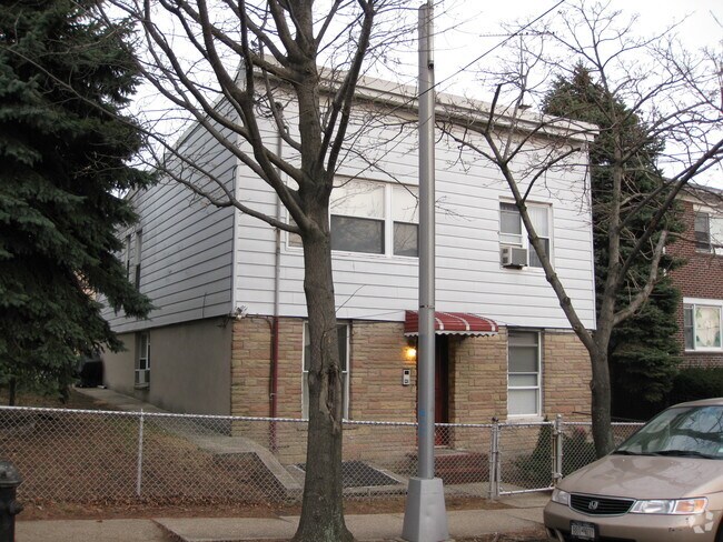
Property Record
5236 72Nd Pl, Maspeth, NY 11378


Property Detail
5236 72Nd Pl
02483-0075
QUEENS
Multifamilydwelling
New York
R4-1
75
B and X Area of moderate flood hazard, usually the area between the limits of the 100-year and 500-year floods.
0.16 AC
2024
Maspeth
2025
Long Island (New York)
049700
New York-Jersey City-White Plains, NY-NJ
4,000 SF
NEARBY LISTINGS FOR SALE OR LEASE
DEMOGRAPHICS near 5236 72Nd Pl
1 mile
3 mile
5 mile
2025 Total Population
113,911
953,515
2,788,956
2030 Population
111,389
943,925
2,793,858
Pop Growth 2025-2030
(2.21%)
(1.01%)
+ 0.18%
Average Age
42
41
40
2025 Total Households
37,401
349,778
1,090,753
HH Growth 2025-2030
(2.91%)
(1.02%)
+ 0.55%
Median Household Inc
$74,584
$84,034
$87,059
Avg Household Size
2.90
2.60
2.40
2025 Avg HH Vehicles
1.00
1.00
1.00
Median Home Value
$753,096
$710,892
$800,676
Median Year Built
1957
1951
1953
Nearby Places
Map Layers
Map Styles
 Street
 Aerial
Transit
 Traffic
 Biking
Places
Listings with unknown addresses are not visible on the map
- Restaurants
- Banks
- Shops
- Fitness
- Groceries
PUBLIC TRANSPORTATION
TRANSIT/SUBWAY
Grand Avenue-Newtown (E - New York MTA Subway (The Subway), M - New York MTA Subway (The Subway), R - New York MTA Subway (The Subway))
Drive
Walk
Distance
Grand Avenue-Newtown (E - New York MTA Subway (The Subway), M - New York MTA Subway (The Subway), R - New York MTA Subway (The Subway))
4 min
19 min
1.0 mi
COMMUTER RAIL
Woodside Station (Babylon Branch - Long Island Rail Road, Far Rockaway Branch - Long Island Rail Road, Hempstead Branch - Long Island Rail Road, Long Beach Branch - Long Island Rail Road, Montauk Branch - Long Island Rail Road, Port Jefferson Branch - Long Island Rail Road, Port Washington Branch - Long Island Rail Road, Ronkonkoma Branch - Long Island Rail Road)
Drive
Walk
Distance
Woodside Station (Babylon Branch - Long Island Rail Road, Far Rockaway Branch - Long Island Rail Road, Hempstead Branch - Long Island Rail Road, Long Beach Branch - Long Island Rail Road, Montauk Branch - Long Island Rail Road, Port Jefferson Branch - Long Island Rail Road, Port Washington Branch - Long Island Rail Road, Ronkonkoma Branch - Long Island Rail Road)
5 min
1.5 mi
Forest Hills Station (Babylon Branch - Long Island Rail Road, Hempstead Branch - Long Island Rail Road, Long Beach Branch - Long Island Rail Road, Port Jefferson Branch - Long Island Rail Road)
Drive
Walk
Distance
Forest Hills Station (Babylon Branch - Long Island Rail Road, Hempstead Branch - Long Island Rail Road, Long Beach Branch - Long Island Rail Road, Port Jefferson Branch - Long Island Rail Road)
10 min
3.2 mi
AIRPORT
LaGuardia
Drive
Walk
Distance
LaGuardia
10 min
4.2 mi
John F Kennedy International
Drive
Walk
Distance
John F Kennedy International
20 min
11.7 mi
Newark Liberty International
Drive
Walk
Distance
Newark Liberty International
34 min
20.2 mi
Freight Ports
NY - Red Hook Container Terminal
Drive
Walk
Distance
NY - Red Hook Container Terminal
18 min
9.0 mi
Nearby Properties
Address
Land Use
TOTAL SIZE
Lot Size
Zoning
Address
Land Use
TOTAL SIZE
Lot Size
Zoning
1,258,350 SF
410.24 AC
PARK
Address
Land Use
TOTAL SIZE
Lot Size
Zoning
1,065,915 SF
2.13 AC
M16R10
Address
Land Use
TOTAL SIZE
Lot Size
Zoning
1,502,532 SF
6.35 AC
R7B
Address
Land Use
TOTAL SIZE
Lot Size
Zoning
772,163 SF
5.24 AC
C4-5X
Address
Land Use
TOTAL SIZE
Lot Size
Zoning
54,170 SF
229.57 AC
PARK
Address
Land Use
TOTAL SIZE
Lot Size
Zoning
1,359,110 SF
1.89 AC
C5-3
Address
Land Use
TOTAL SIZE
Lot Size
Zoning
1,292,074 SF
C4-2F
Address
Land Use
TOTAL SIZE
Lot Size
Zoning
234,891 SF
3.17 AC
C4-5X
Address
Land Use
TOTAL SIZE
Lot Size
Zoning
882,579 SF
0.51 AC
M16R10
Address
Land Use
TOTAL SIZE
Lot Size
Zoning
505,416 SF
M16R10
Address
Land Use
TOTAL SIZE
Lot Size
Zoning
710,860 SF
1.52 AC
M15R9
Address
Land Use
TOTAL SIZE
Lot Size
Zoning
1,516,458 SF
5.97 AC
R7-1
Address
Land Use
TOTAL SIZE
Lot Size
Zoning
15,000 SF
255.27 AC
PARK
Address
Land Use
TOTAL SIZE
Lot Size
Zoning
777,258 SF
4.67 AC
M3-2
Address
Land Use
TOTAL SIZE
Lot Size
Zoning
863,800 SF
2.71 AC
M1-4
Address
Land Use
TOTAL SIZE
Lot Size
Zoning
682,549 SF
1.12 AC
M16R10
Address
Land Use
TOTAL SIZE
Lot Size
Zoning
519,182 SF
0.50 AC
M16R10
Address
Land Use
TOTAL SIZE
Lot Size
Zoning
524,716 SF
1.60 AC
M16R10
Address
Land Use
TOTAL SIZE
Lot Size
Zoning
1,119,826 SF
2.76 AC
M1-4
Address
Land Use
TOTAL SIZE
Lot Size
Zoning
1,000 SF
210.07 AC
R3-2
Address
Land Use
TOTAL SIZE
Lot Size
Zoning
1,572,198 SF
22.06 AC
M1-2
Address
Land Use
TOTAL SIZE
Lot Size
Zoning
512,815 SF
0.63 AC
M16R10
Address
Land Use
TOTAL SIZE
Lot Size
Zoning
344,116 SF
0.92 AC
R7-1
Address
Land Use
TOTAL SIZE
Lot Size
Zoning
948,188 SF
1.30 AC
M16R10
Address
Land Use
TOTAL SIZE
Lot Size
Zoning
826,915 SF
8.83 AC
M3-1
Address
Land Use
TOTAL SIZE
Lot Size
Zoning
446,763 SF
12.52 AC
R6
Address
Land Use
TOTAL SIZE
Lot Size
Zoning
360,000 SF
5.88 AC
C4-2
Address
Land Use
TOTAL SIZE
Lot Size
Zoning
307,038 SF
7.84 AC
M1-1
Address
Land Use
TOTAL SIZE
Lot Size
Zoning
462,917 SF
0.40 AC
M16R10
Address
Land Use
TOTAL SIZE
Lot Size
Zoning
458,778 SF
2.09 AC
R6
The World's #1 Commercial Real Estate Marketplace
Connect with us
© 2026 CoStar Group
The information above has been obtained from sources believed reliable. While we do not doubt its accuracy we have not verified it and make no guarantee, warranty or representation about it. It is your responsibility to independently confirm its accuracy and completeness. Any projections, opinions, assumptions, or estimates used are for example only and do not represent the current or future performance of the property. The value of this transaction to you depends on tax and other factors which should be evaluated by your tax, financial, and legal advisors. You and your advisors should conduct a careful, independent investigation of the property to determine to your satisfaction the suitability of the property for your needs.