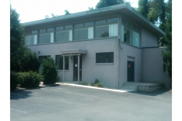
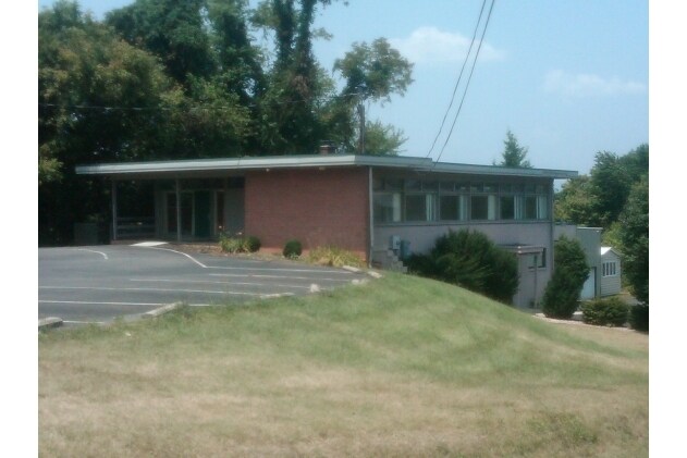
Property Record
5236 S Amherst Hwy, Madison Heights, VA 24572
NEARBY LISTINGS FOR SALE OR LEASE
Property Detail
5236 S Amherst Hwy
Lynchburg, VA
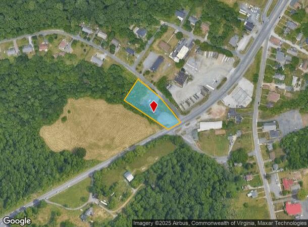
Map Showing Subdivision Of Florence M Me
160A2-1-B-1
LOT 1 BLK B MERRYMAN 160A2 1 B 1
Officebuilding
Amherst
X
Virginia
51009C0395C
1
2024
0.91 AC
2025
Lynchburg
010506
Other Market Areas
4,052 SF
DEMOGRAPHICS near 5236 S Amherst Hwy
1 Mile
3 Mile
5 Mile
2024 Total Population
2,897
28,406
59,923
2029 Population
2,964
28,819
60,269
Pop Growth 2024-2029
+ 2.31%
+ 1.45%
+ 0.58%
Average Age
41
38
38
2024 Total Households
1,276
12,208
24,552
HH Growth 2024-2029
+ 2.43%
+ 1.52%
+ 0.62%
Median Household Inc
$44,845
$42,873
$50,440
Avg Household Size
2.30
2.20
2.20
2024 Avg HH Vehicles
2.00
2.00
2.00
Median Home Value
$140,993
$132,912
$159,660
Median Year Built
1963
1955
1961
Nearby Places
Map Layers
Map Styles
 Street
 Aerial
- Restaurants
- Banks
- Shops
- Fitness
- Groceries
PUBLIC TRANSPORTATION
COMMUTER RAIL
Lynchburg (Crescent - Amtrak, Northeast Regional - Amtrak)
DRIVE
WALK
Distance
Lynchburg (Crescent - Amtrak, Northeast Regional - Amtrak)
6 min
3.8 mi
AIRPORT
Lynchburg Regional/Preston Glenn Field
DRIVE
WALK
Distance
Lynchburg Regional/Preston Glenn Field
18 min
11.2 mi
Freight Ports
Virginia Port Authority - Richmond
DRIVE
WALK
Distance
Virginia Port Authority - Richmond
151 min
111.9 mi
Nearby Properties
Address
Land Use
TOTAL SIZE
Lot Size
Zoning
Address
Land Use
TOTAL SIZE
Lot Size
Zoning
686,112 SF
29.65 AC
B1R2
Address
Land Use
TOTAL SIZE
Lot Size
Zoning
626,329 SF
50.88 AC
2521
Address
Land Use
TOTAL SIZE
Lot Size
Zoning
323,985 SF
50.89 AC
2305
Address
Land Use
TOTAL SIZE
Lot Size
Zoning
186,536 SF
21.45 AC
P1
Address
Land Use
TOTAL SIZE
Lot Size
Zoning
183,584 SF
2 AC
R4
Address
Land Use
TOTAL SIZE
Lot Size
Zoning
68,240 SF
20.56 AC
R4
Address
Land Use
TOTAL SIZE
Lot Size
Zoning
91,070 SF
9.80 AC
B3
Address
Land Use
TOTAL SIZE
Lot Size
Zoning
118,789 SF
1.90 AC
2501
Address
Land Use
TOTAL SIZE
Lot Size
Zoning
3.67 AC
I3RC
Address
Land Use
TOTAL SIZE
Lot Size
Zoning
114,738 SF
0.51 AC
B4
Address
Land Use
TOTAL SIZE
Lot Size
Zoning
46,689 SF
1.74 AC
B6
Address
Land Use
TOTAL SIZE
Lot Size
Zoning
21,542 SF
41.78 AC
R2
Address
Land Use
TOTAL SIZE
Lot Size
Zoning
53,907 SF
10.38 AC
R3
Address
Land Use
TOTAL SIZE
Lot Size
Zoning
80,165 SF
1.26 AC
090125
Address
Land Use
TOTAL SIZE
Lot Size
Zoning
66,832 SF
48.77 AC
B2
Address
Land Use
TOTAL SIZE
Lot Size
Zoning
342,948 SF
1.94 AC
B4
Address
Land Use
TOTAL SIZE
Lot Size
Zoning
21,360 SF
3 AC
I3
Address
Land Use
TOTAL SIZE
Lot Size
Zoning
150,883 SF
7.41 AC
R4
Address
Land Use
TOTAL SIZE
Lot Size
Zoning
152,112 SF
4.74 AC
R3
Address
Land Use
TOTAL SIZE
Lot Size
Zoning
57,270 SF
1.56 AC
B6
Address
Land Use
TOTAL SIZE
Lot Size
Zoning
124,905 SF
6.84 AC
R4
Address
Land Use
TOTAL SIZE
Lot Size
Zoning
80,357 SF
1.19 AC
R3
Address
Land Use
TOTAL SIZE
Lot Size
Zoning
337,791 SF
24.92 AC
B3B5
Address
Land Use
TOTAL SIZE
Lot Size
Zoning
88,473 SF
0.97 AC
B4
Address
Land Use
TOTAL SIZE
Lot Size
Zoning
134,387 SF
12.17 AC
B2
Address
Land Use
TOTAL SIZE
Lot Size
Zoning
9.79 AC
B2
Address
Land Use
TOTAL SIZE
Lot Size
Zoning
61,415 SF
24.11 AC
P1
Address
Land Use
TOTAL SIZE
Lot Size
Zoning
154,922 SF
16.89 AC
B2
Address
Land Use
TOTAL SIZE
Lot Size
Zoning
67,310 SF
1.44 AC
B6
The World's #1 Commercial Real Estate Marketplace
Connect with us
© 2025 CoStar Group
The information above has been obtained from sources believed reliable. While we do not doubt its accuracy we have not verified it and make no guarantee, warranty or representation about it. It is your responsibility to independently confirm its accuracy and completeness. Any projections, opinions, assumptions, or estimates used are for example only and do not represent the current or future performance of the property. The value of this transaction to you depends on tax and other factors which should be evaluated by your tax, financial, and legal advisors. You and your advisors should conduct a careful, independent investigation of the property to determine to your satisfaction the suitability of the property for your needs.