Property Record
5237 N Harlem Ave, Chicago, IL 60656

Property Detail
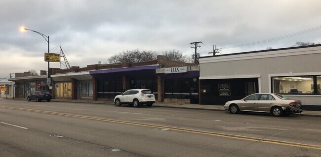
5237 N Harlem Ave
13-07-127-061-0000
(MCCOLLAM) & (KRUGGELS) ADD TO NORWOOD PK IN WH SEC 07-40-13
Commercialbuilding
COOK
B1-1
Illinois
B and X Area of moderate flood hazard, usually the area between the limits of the 100-year and 500-year floods.
24
2023
0.30 AC
2025
Northwest City
100600
Chicago
1,129 SF
Chicago-Naperville-Elgin, IL-IN
NEARBY LISTINGS FOR SALE OR LEASE
DEMOGRAPHICS near 5237 N Harlem Ave
1 mile
3 mile
5 mile
2025 Total Population
28,248
223,068
593,666
2030 Population
28,225
220,708
585,417
Pop Growth 2025-2030
(0.08%)
(1.06%)
(1.39%)
Average Age
44
43
42
2025 Total Households
11,181
85,306
216,755
HH Growth 2025-2030
(0.24%)
(1.29%)
(1.56%)
Median Household Inc
$96,708
$98,123
$90,164
Avg Household Size
2.40
2.50
2.60
2025 Avg HH Vehicles
2.00
2.00
2.00
Median Home Value
$369,793
$379,728
$369,642
Median Year Built
1957
1955
1953
Nearby Places
Map Layers
Map Styles
 Street
 Aerial
Transit
 Traffic
 Biking
Places
Listings with unknown addresses are not visible on the map
- Restaurants
- Banks
- Shops
- Fitness
- Groceries
PUBLIC TRANSPORTATION
TRANSIT/SUBWAY
Harlem Station (Blue Line - O'Hare Branch) (Blue Line - Chicago Transit Authority "L" Trains (The "L"))
Drive
Walk
Distance
Harlem Station (Blue Line - O'Hare Branch) (Blue Line - Chicago Transit Authority "L" Trains (The "L"))
4 min
11 min
0.6 mi
COMMUTER RAIL
Norwood Park Station (Union Pacific Northwest Line - Northeast Illinois Regional Commuter Railroad (Metra))
Drive
Walk
Distance
Norwood Park Station (Union Pacific Northwest Line - Northeast Illinois Regional Commuter Railroad (Metra))
4 min
1.8 mi
Gladstone Park Station (Union Pacific Northwest Line - Northeast Illinois Regional Commuter Railroad (Metra))
Drive
Walk
Distance
Gladstone Park Station (Union Pacific Northwest Line - Northeast Illinois Regional Commuter Railroad (Metra))
5 min
2.1 mi
AIRPORT
Chicago O'Hare International
Drive
Walk
Distance
Chicago O'Hare International
31 min
9.3 mi
Chicago Midway International
Drive
Walk
Distance
Chicago Midway International
34 min
17.2 mi
SALE & LEASE HISTORY
LISTING DATE
SALE/LEASE

Jun 17, 2021
For Sale
Dec 12, 2019
For Sale
Apr 29, 2019
For Sale
Nearby Properties
Address
Land Use
TOTAL SIZE
Lot Size
Zoning
Address
Land Use
TOTAL SIZE
Lot Size
Zoning
240,942 SF
15.94 AC
PD 72
Address
Land Use
TOTAL SIZE
Lot Size
Zoning
833,077 SF
11.90 AC
Address
Land Use
TOTAL SIZE
Lot Size
Zoning
203,090 SF
7.96 AC
Address
Land Use
TOTAL SIZE
Lot Size
Zoning
809,460 SF
6.60 AC
PD 258
Address
Land Use
TOTAL SIZE
Lot Size
Zoning
697,000 SF
11.60 AC
PD 71
Address
Land Use
TOTAL SIZE
Lot Size
Zoning
2.62 AC
Address
Land Use
TOTAL SIZE
Lot Size
Zoning
403,200 SF
6.82 AC
PD 193
Address
Land Use
TOTAL SIZE
Lot Size
Zoning
398,424 SF
3.08 AC
PD 71
Address
Land Use
TOTAL SIZE
Lot Size
Zoning
9.90 AC
Address
Land Use
TOTAL SIZE
Lot Size
Zoning
920,000 SF
7.45 AC
PD 193
Address
Land Use
TOTAL SIZE
Lot Size
Zoning
555,681 SF
7.36 AC
PD 340
Address
Land Use
TOTAL SIZE
Lot Size
Zoning
248,726 SF
11.79 AC
PD 44
Address
Land Use
TOTAL SIZE
Lot Size
Zoning
1.30 AC
Address
Land Use
TOTAL SIZE
Lot Size
Zoning
310,145 SF
5.08 AC
PD 71
Address
Land Use
TOTAL SIZE
Lot Size
Zoning
372,935 SF
7.34 AC
Address
Land Use
TOTAL SIZE
Lot Size
Zoning
869,120 SF
2.81 AC
Address
Land Use
TOTAL SIZE
Lot Size
Zoning
2.19 AC
Address
Land Use
TOTAL SIZE
Lot Size
Zoning
845,318 SF
7.09 AC
Address
Land Use
TOTAL SIZE
Lot Size
Zoning
403,815 SF
0.77 AC
Address
Land Use
TOTAL SIZE
Lot Size
Zoning
334,000 SF
1.77 AC
Address
Land Use
TOTAL SIZE
Lot Size
Zoning
221,692 SF
2.12 AC
Address
Land Use
TOTAL SIZE
Lot Size
Zoning
1.04 AC
PD 130
Address
Land Use
TOTAL SIZE
Lot Size
Zoning
9.38 AC
PD 1179,PO
Address
Land Use
TOTAL SIZE
Lot Size
Zoning
92,457 SF
4.09 AC
Address
Land Use
TOTAL SIZE
Lot Size
Zoning
121,117 SF
3.09 AC
Address
Land Use
TOTAL SIZE
Lot Size
Zoning
246,000 SF
2.29 AC
PD 340
Address
Land Use
TOTAL SIZE
Lot Size
Zoning
210,102 SF
4.22 AC
Address
Land Use
TOTAL SIZE
Lot Size
Zoning
322,805 SF
Address
Land Use
TOTAL SIZE
Lot Size
Zoning
1,201,215 SF
8.27 AC
B1-3,RT-4
Address
Land Use
TOTAL SIZE
Lot Size
Zoning
286,801 SF
0.94 AC
The World's #1 Commercial Real Estate Marketplace
Connect with us
© 2026 CoStar Group
The information above has been obtained from sources believed reliable. While we do not doubt its accuracy we have not verified it and make no guarantee, warranty or representation about it. It is your responsibility to independently confirm its accuracy and completeness. Any projections, opinions, assumptions, or estimates used are for example only and do not represent the current or future performance of the property. The value of this transaction to you depends on tax and other factors which should be evaluated by your tax, financial, and legal advisors. You and your advisors should conduct a careful, independent investigation of the property to determine to your satisfaction the suitability of the property for your needs.