Property Record
5241 Us Highway 377 S, Aubrey, TX 76227
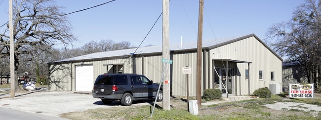


Property Detail
5241 Us Highway 377 S
R155320
COUNTRY ESTATES 2 BUSINESS AREA A (S PT)
Commercialnec
Denton
B and X Area of moderate flood hazard, usually the area between the limits of the 100-year and 500-year floods.
Texas
2024
0.19 AC
2025
Outlying Denton County
020116
Dallas/Ft Worth
4,000 SF
Dallas-Fort Worth-Arlington, TX
NEARBY LISTINGS FOR SALE OR LEASE
-
-
View all Aubrey listings for lease on LoopNet.com
DEMOGRAPHICS near 5241 Us Highway 377 S
1 mile
3 mile
5 mile
2024 Total Population
4,211
15,939
44,737
2029 Population
4,809
18,593
51,975
Pop Growth 2024-2029
+ 14.20%
+ 16.65%
+ 16.18%
Average Age
40
37
37
2024 Total Households
1,524
5,762
15,848
HH Growth 2024-2029
+ 14.70%
+ 17.16%
+ 16.65%
Median Household Inc
$109,815
$105,428
$104,853
Avg Household Size
2.80
2.80
2.80
2024 Avg HH Vehicles
2.00
2.00
2.00
Median Home Value
$399,999
$396,112
$398,927
Median Year Built
2008
2011
2010
Nearby Places
Map Layers
Map Styles
 Street
 Aerial
Transit
 Traffic
 Biking
Places
Listings with unknown addresses are not visible on the map
- Restaurants
- Banks
- Shops
- Fitness
- Groceries
PUBLIC TRANSPORTATION
AIRPORT
Dallas-Fort Worth International
Drive
Walk
Distance
Dallas-Fort Worth International
48 min
33.2 mi
Dallas Love Field
Drive
Walk
Distance
Dallas Love Field
57 min
43.8 mi
SALE & LEASE HISTORY
LISTING DATE
SALE/LEASE

Feb 17, 2017
For Lease
Nearby Properties
Address
Land Use
TOTAL SIZE
Lot Size
Zoning
Address
Land Use
TOTAL SIZE
Lot Size
Zoning
249,782 SF
48.28 AC
Address
Land Use
TOTAL SIZE
Lot Size
Zoning
91,745 SF
15.10 AC
Address
Land Use
TOTAL SIZE
Lot Size
Zoning
91,438 SF
13.06 AC
Address
Land Use
TOTAL SIZE
Lot Size
Zoning
141,215 SF
32 AC
Address
Land Use
TOTAL SIZE
Lot Size
Zoning
148,012 SF
17.34 AC
Address
Land Use
TOTAL SIZE
Lot Size
Zoning
169,130 SF
8.50 AC
Address
Land Use
TOTAL SIZE
Lot Size
Zoning
58,500 SF
6.11 AC
Address
Land Use
TOTAL SIZE
Lot Size
Zoning
63,434 SF
10.70 AC
Address
Land Use
TOTAL SIZE
Lot Size
Zoning
30,340 SF
9.27 AC
Address
Land Use
TOTAL SIZE
Lot Size
Zoning
68,910 SF
16.02 AC
Address
Land Use
TOTAL SIZE
Lot Size
Zoning
182,174 SF
19.81 AC
Address
Land Use
TOTAL SIZE
Lot Size
Zoning
4,900 SF
9.84 AC
Address
Land Use
TOTAL SIZE
Lot Size
Zoning
54,874 SF
5 AC
Address
Land Use
TOTAL SIZE
Lot Size
Zoning
24,161 SF
5.81 AC
Address
Land Use
TOTAL SIZE
Lot Size
Zoning
13,962 SF
6.41 AC
Address
Land Use
TOTAL SIZE
Lot Size
Zoning
59,868 SF
2.91 AC
Address
Land Use
TOTAL SIZE
Lot Size
Zoning
8,080 SF
60.39 AC
Address
Land Use
TOTAL SIZE
Lot Size
Zoning
21,600 SF
8.89 AC
Address
Land Use
TOTAL SIZE
Lot Size
Zoning
79.40 AC
Address
Land Use
TOTAL SIZE
Lot Size
Zoning
44,690 SF
4.01 AC
Address
Land Use
TOTAL SIZE
Lot Size
Zoning
37,676 SF
Address
Land Use
TOTAL SIZE
Lot Size
Zoning
2,166 SF
45.26 AC
Address
Land Use
TOTAL SIZE
Lot Size
Zoning
24.96 AC
Address
Land Use
TOTAL SIZE
Lot Size
Zoning
17,650 SF
18.96 AC
Address
Land Use
TOTAL SIZE
Lot Size
Zoning
124,996 SF
10 AC
Address
Land Use
TOTAL SIZE
Lot Size
Zoning
69,960 SF
12.96 AC
Address
Land Use
TOTAL SIZE
Lot Size
Zoning
2,724 SF
58.10 AC
Address
Land Use
TOTAL SIZE
Lot Size
Zoning
11,250 SF
1.75 AC
Address
Land Use
TOTAL SIZE
Lot Size
Zoning
34.63 AC
Address
Land Use
TOTAL SIZE
Lot Size
Zoning
13,199 SF
208.81 AC
The World's #1 Commercial Real Estate Marketplace
Connect with us
© 2026 CoStar Group
The information above has been obtained from sources believed reliable. While we do not doubt its accuracy we have not verified it and make no guarantee, warranty or representation about it. It is your responsibility to independently confirm its accuracy and completeness. Any projections, opinions, assumptions, or estimates used are for example only and do not represent the current or future performance of the property. The value of this transaction to you depends on tax and other factors which should be evaluated by your tax, financial, and legal advisors. You and your advisors should conduct a careful, independent investigation of the property to determine to your satisfaction the suitability of the property for your needs.