Property Record
5245 Highway 62, Eagle Point, OR 97524
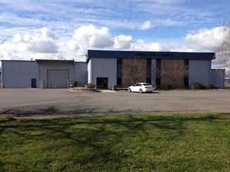

Property Detail
5245 Highway 62
Commercialbuilding
JACKSON
GC
Oregon
B and X Area of moderate flood hazard, usually the area between the limits of the 100-year and 500-year floods.
3.50 AC
2025
Medford/Grants Pass
2026
Other Market Areas
001403
Medford, OR
21,750 SF
10459081
NEARBY LISTINGS FOR SALE OR LEASE
DEMOGRAPHICS near 5245 Highway 62
1 mile
3 mile
5 mile
2025 Total Population
376
29,806
87,629
2030 Population
380
29,312
86,264
Pop Growth 2025-2030
+ 1.06%
(1.66%)
(1.56%)
Average Age
43
40
41
2025 Total Households
113
10,877
33,307
HH Growth 2025-2030
+ 0.88%
(1.87%)
(1.72%)
Median Household Inc
$82,812
$79,424
$73,035
Avg Household Size
2.80
2.60
2.50
2025 Avg HH Vehicles
3.00
2.00
2.00
Median Home Value
$418,421
$370,849
$381,336
Median Year Built
1984
1990
1984
Nearby Places
Map Layers
Map Styles
 Street
 Aerial
Layers
 Traffic
 Biking
Places
Listings with unknown addresses are not visible on the map
- Restaurants
- Banks
- Shops
- Fitness
- Groceries
PUBLIC TRANSPORTATION
AIRPORT
Rogue Valley International - Medford
Drive
Walk
Distance
Rogue Valley International - Medford
7 min
3.5 mi
Freight Ports
Port of Coos Bay, OR
Drive
Walk
Distance
Port of Coos Bay, OR
217 min
164.0 mi
SALE & LEASE HISTORY
LISTING DATE
SALE/LEASE

Feb 08, 2021
For Sale
Nearby Properties
Address
Land Use
TOTAL SIZE
Lot Size
Zoning
Address
Land Use
TOTAL SIZE
Lot Size
Zoning
290.83 AC
I-L
Address
Land Use
TOTAL SIZE
Lot Size
Zoning
600,000 SF
18.27 AC
M-1
Address
Land Use
TOTAL SIZE
Lot Size
Zoning
73.48 AC
GI
Address
Land Use
TOTAL SIZE
Lot Size
Zoning
88,434 SF
12.10 AC
I-L
Address
Land Use
TOTAL SIZE
Lot Size
Zoning
125,910 SF
14.29 AC
C-R
Address
Land Use
TOTAL SIZE
Lot Size
Zoning
88.67 AC
I-L
Address
Land Use
TOTAL SIZE
Lot Size
Zoning
136,756 SF
12.50 AC
C-R
Address
Land Use
TOTAL SIZE
Lot Size
Zoning
177.42 AC
GI
Address
Land Use
TOTAL SIZE
Lot Size
Zoning
35,272 SF
10.01 AC
GI
Address
Land Use
TOTAL SIZE
Lot Size
Zoning
13.49 AC
M-1
Address
Land Use
TOTAL SIZE
Lot Size
Zoning
25.77 AC
GI
Address
Land Use
TOTAL SIZE
Lot Size
Zoning
31,283 SF
2.95 AC
I-L
Address
Land Use
TOTAL SIZE
Lot Size
Zoning
164,324 SF
7.40 AC
C-R
Address
Land Use
TOTAL SIZE
Lot Size
Zoning
144,396 SF
10.67 AC
C-R
Address
Land Use
TOTAL SIZE
Lot Size
Zoning
102,184 SF
5.82 AC
I-L
Address
Land Use
TOTAL SIZE
Lot Size
Zoning
164,324 SF
6.42 AC
C-R
Address
Land Use
TOTAL SIZE
Lot Size
Zoning
98,547 SF
4.36 AC
I-L
Address
Land Use
TOTAL SIZE
Lot Size
Zoning
37.62 AC
GI
Address
Land Use
TOTAL SIZE
Lot Size
Zoning
54,823 SF
15.17 AC
I-L
Address
Land Use
TOTAL SIZE
Lot Size
Zoning
45,406 SF
3.29 AC
MFR-15
Address
Land Use
TOTAL SIZE
Lot Size
Zoning
32,614 SF
8.27 AC
M-1
Address
Land Use
TOTAL SIZE
Lot Size
Zoning
32,240 SF
20.24 AC
M-2
Address
Land Use
TOTAL SIZE
Lot Size
Zoning
27.82 AC
I-H
Address
Land Use
TOTAL SIZE
Lot Size
Zoning
39.24 AC
GI
Address
Land Use
TOTAL SIZE
Lot Size
Zoning
100,000 SF
5.77 AC
I-G
Address
Land Use
TOTAL SIZE
Lot Size
Zoning
79,447 SF
6.69 AC
C-R
Address
Land Use
TOTAL SIZE
Lot Size
Zoning
117,062 SF
5.13 AC
C-R
Address
Land Use
TOTAL SIZE
Lot Size
Zoning
55,594 SF
4.88 AC
C-R
Address
Land Use
TOTAL SIZE
Lot Size
Zoning
56,962 SF
2.71 AC
C-R
Address
Land Use
TOTAL SIZE
Lot Size
Zoning
92,750 SF
102.77 AC
I-L
The World's #1 Commercial Real Estate Marketplace
Connect with us
© 2026 CoStar Group
The information above has been obtained from sources believed reliable. While we do not doubt its accuracy we have not verified it and make no guarantee, warranty or representation about it. It is your responsibility to independently confirm its accuracy and completeness. Any projections, opinions, assumptions, or estimates used are for example only and do not represent the current or future performance of the property. The value of this transaction to you depends on tax and other factors which should be evaluated by your tax, financial, and legal advisors. You and your advisors should conduct a careful, independent investigation of the property to determine to your satisfaction the suitability of the property for your needs.