Property Record
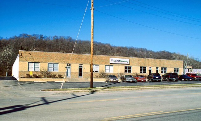
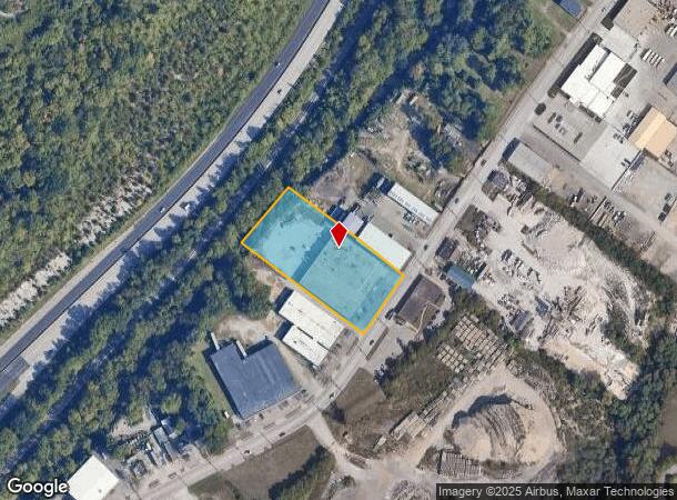
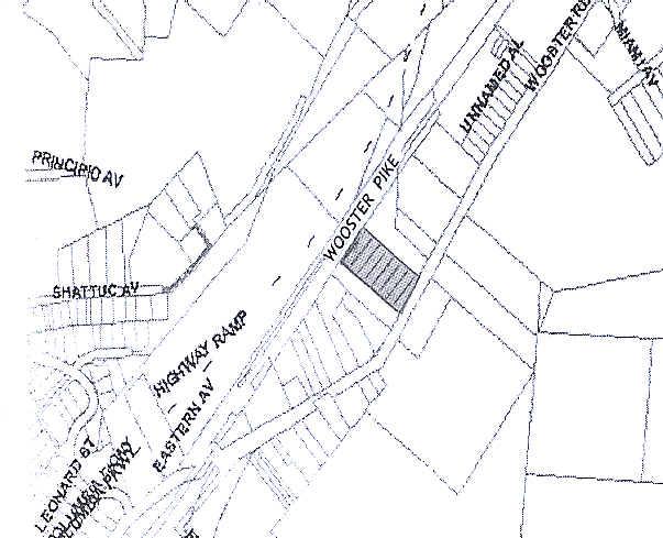
5246 Wooster Pike, Cincinnati, OH 45226
NEARBY LISTINGS FOR SALE OR LEASE
Property Detail
5246 Wooster Pike
020-0003-0051
5246 EASTERN AVE 196.62 X 424.64 IRR R2 -T4- S14-20 PARS 51-55 CONS
Warehouse
Hamilton
AE
Ohio
39061C0243F
1.84 AC
2024
Central/Midtown
2024
Cincinnati/Dayton
004703
Cincinnati, OH-KY-IN
29,815 SF
DEMOGRAPHICS near 5246 Wooster Pike
1 Mile
3 Mile
5 Mile
2024 Total Population
4,157
68,610
213,923
2029 Population
4,076
67,927
212,779
Pop Growth 2024-2029
(1.95%)
(1.00%)
(0.53%)
Average Age
39
39
39
2024 Total Households
1,747
32,906
95,568
HH Growth 2024-2029
(1.95%)
(1.09%)
(0.66%)
Median Household Inc
$144,942
$87,357
$73,689
Avg Household Size
2.30
2.00
2.10
2024 Avg HH Vehicles
2.00
2.00
2.00
Median Home Value
$496,680
$330,982
$265,049
Median Year Built
1948
1952
1951
Nearby Places
Map Layers
Map Styles
 Street
 Aerial
- Restaurants
- Banks
- Shops
- Fitness
- Groceries
PUBLIC TRANSPORTATION
AIRPORT
Cincinnati/Northern Kentucky International
DRIVE
WALK
Distance
Cincinnati/Northern Kentucky International
39 min
22.1 mi
Freight Ports
Port of Toledo
DRIVE
WALK
Distance
Port of Toledo
243 min
206.7 mi
Nearby Properties
Address
Land Use
TOTAL SIZE
Lot Size
Zoning
Address
Land Use
TOTAL SIZE
Lot Size
Zoning
27.30 AC
M2
Address
Land Use
TOTAL SIZE
Lot Size
Zoning
26,453 SF
19.91 AC
M2
Address
Land Use
TOTAL SIZE
Lot Size
Zoning
148,748 SF
24.90 AC
CGA
Address
Land Use
TOTAL SIZE
Lot Size
Zoning
3.17 AC
R2PUD
Address
Land Use
TOTAL SIZE
Lot Size
Zoning
9.16 AC
Address
Land Use
TOTAL SIZE
Lot Size
Zoning
Address
Land Use
TOTAL SIZE
Lot Size
Zoning
10.76 AC
Address
Land Use
TOTAL SIZE
Lot Size
Zoning
5.07 AC
Address
Land Use
TOTAL SIZE
Lot Size
Zoning
Address
Land Use
TOTAL SIZE
Lot Size
Zoning
6.93 AC
MG
Address
Land Use
TOTAL SIZE
Lot Size
Zoning
12.46 AC
Address
Land Use
TOTAL SIZE
Lot Size
Zoning
0.26 AC
RM12
Address
Land Use
TOTAL SIZE
Lot Size
Zoning
8.05 AC
Address
Land Use
TOTAL SIZE
Lot Size
Zoning
1,187 SF
31.75 AC
ML
Address
Land Use
TOTAL SIZE
Lot Size
Zoning
6.91 AC
Address
Land Use
TOTAL SIZE
Lot Size
Zoning
3,864 SF
0.15 AC
PD
Address
Land Use
TOTAL SIZE
Lot Size
Zoning
19.17 AC
ML
Address
Land Use
TOTAL SIZE
Lot Size
Zoning
4,706 SF
18.29 AC
RM20
Address
Land Use
TOTAL SIZE
Lot Size
Zoning
7.06 AC
Address
Land Use
TOTAL SIZE
Lot Size
Zoning
1,152 SF
24.78 AC
B
Address
Land Use
TOTAL SIZE
Lot Size
Zoning
2.17 AC
O
Address
Land Use
TOTAL SIZE
Lot Size
Zoning
18.51 AC
RM20
Address
Land Use
TOTAL SIZE
Lot Size
Zoning
15.86 AC
Address
Land Use
TOTAL SIZE
Lot Size
Zoning
2.20 AC
Address
Land Use
TOTAL SIZE
Lot Size
Zoning
12.40 AC
Address
Land Use
TOTAL SIZE
Lot Size
Zoning
1,205 SF
41.47 AC
Address
Land Use
TOTAL SIZE
Lot Size
Zoning
81,670 SF
12.50 AC
SF20
Address
Land Use
TOTAL SIZE
Lot Size
Zoning
11.04 AC
SF20
Address
Land Use
TOTAL SIZE
Lot Size
Zoning
0.74 AC
R2PUD
Address
Land Use
TOTAL SIZE
Lot Size
Zoning
1.33 AC
R2PUD
The World's #1 Commercial Real Estate Marketplace
Connect with us
© 2025 CoStar Group
The information above has been obtained from sources believed reliable. While we do not doubt its accuracy we have not verified it and make no guarantee, warranty or representation about it. It is your responsibility to independently confirm its accuracy and completeness. Any projections, opinions, assumptions, or estimates used are for example only and do not represent the current or future performance of the property. The value of this transaction to you depends on tax and other factors which should be evaluated by your tax, financial, and legal advisors. You and your advisors should conduct a careful, independent investigation of the property to determine to your satisfaction the suitability of the property for your needs.