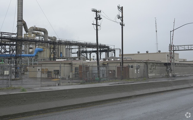
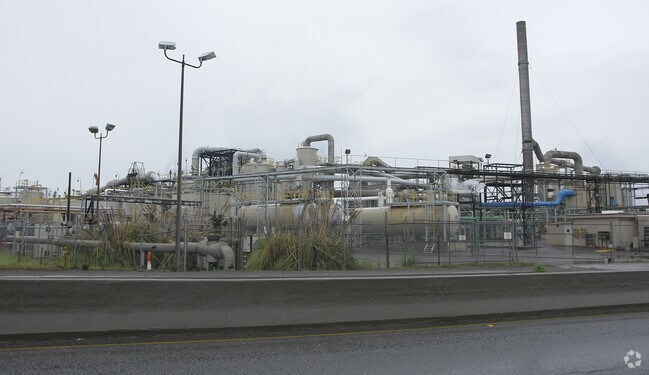
Property Record
525 Castro St, Richmond, CA 94801

Property Detail
525 Castro St
561-100-036-4
POR SEC 11 T1N R5W
Heavyindustrial
CONTRA COSTA
B and X Area of moderate flood hazard, usually the area between the limits of the 100-year and 500-year floods.
California
2025
40.39 AC
2025
Richmond/San Pablo
378000
East Bay/Oakland
19,308 SF
Oakland-Fremont-Berkeley, CA
NEARBY LISTINGS FOR SALE OR LEASE
DEMOGRAPHICS near 525 Castro St
1 mile
3 mile
5 mile
2025 Total Population
12,147
109,813
189,505
2030 Population
12,204
110,637
190,770
Pop Growth 2025-2030
+ 0.47%
+ 0.75%
+ 0.67%
Average Age
35
38
39
2025 Total Households
3,509
33,989
63,115
HH Growth 2025-2030
+ 0.48%
+ 0.81%
+ 0.68%
Median Household Inc
$65,174
$82,532
$91,819
Avg Household Size
3.30
3.10
2.90
2025 Avg HH Vehicles
2.00
2.00
2.00
Median Home Value
$466,935
$657,971
$729,308
Median Year Built
1958
1962
1962
Nearby Places
Map Layers
Map Styles
 Street
 Aerial
Layers
 Traffic
 Biking
Places
Listings with unknown addresses are not visible on the map
- Restaurants
- Banks
- Shops
- Fitness
- Groceries
PUBLIC TRANSPORTATION
COMMUTER RAIL
Richmond (Capitol Corridor - Capitol Corridor Joint Powers Authority)
Drive
Walk
Distance
Richmond (Capitol Corridor - Capitol Corridor Joint Powers Authority)
7 min
3.3 mi
Berkeley Amtrak (Capitol Corridor - Amtrak)
Drive
Walk
Distance
Berkeley Amtrak (Capitol Corridor - Amtrak)
11 min
9.0 mi
AIRPORT
Metro Oakland International
Drive
Walk
Distance
Metro Oakland International
32 min
23.9 mi
San Francisco International
Drive
Walk
Distance
San Francisco International
44 min
31.5 mi
Freight Ports
Port of Richmond
Drive
Walk
Distance
Port of Richmond
9 min
4.1 mi
Nearby Properties
Address
Land Use
TOTAL SIZE
Lot Size
Zoning
Address
Land Use
TOTAL SIZE
Lot Size
Zoning
244.30 AC
Address
Land Use
TOTAL SIZE
Lot Size
Zoning
55.76 AC
Address
Land Use
TOTAL SIZE
Lot Size
Zoning
269.14 AC
Address
Land Use
TOTAL SIZE
Lot Size
Zoning
38.33 AC
Address
Land Use
TOTAL SIZE
Lot Size
Zoning
820,000 SF
6.36 AC
Address
Land Use
TOTAL SIZE
Lot Size
Zoning
68,400 SF
5.13 AC
CM
Address
Land Use
TOTAL SIZE
Lot Size
Zoning
76.15 AC
Address
Land Use
TOTAL SIZE
Lot Size
Zoning
481,487 SF
27.88 AC
P-1
Address
Land Use
TOTAL SIZE
Lot Size
Zoning
205,900 SF
20.70 AC
P1
Address
Land Use
TOTAL SIZE
Lot Size
Zoning
476,200 SF
22.92 AC
Address
Land Use
TOTAL SIZE
Lot Size
Zoning
581,157 SF
10.52 AC
Address
Land Use
TOTAL SIZE
Lot Size
Zoning
195,281 SF
0.96 AC
Address
Land Use
TOTAL SIZE
Lot Size
Zoning
163,721 SF
0.76 AC
Address
Land Use
TOTAL SIZE
Lot Size
Zoning
3,950 SF
11.47 AC
Address
Land Use
TOTAL SIZE
Lot Size
Zoning
105,704 SF
10.85 AC
M3
Address
Land Use
TOTAL SIZE
Lot Size
Zoning
35.94 AC
Address
Land Use
TOTAL SIZE
Lot Size
Zoning
22.06 AC
Address
Land Use
TOTAL SIZE
Lot Size
Zoning
16,800 SF
11.62 AC
Address
Land Use
TOTAL SIZE
Lot Size
Zoning
4,550 SF
24.81 AC
Address
Land Use
TOTAL SIZE
Lot Size
Zoning
245,894 SF
12.67 AC
M2
Address
Land Use
TOTAL SIZE
Lot Size
Zoning
202,811 SF
10.98 AC
Address
Land Use
TOTAL SIZE
Lot Size
Zoning
113,346 SF
10.11 AC
Address
Land Use
TOTAL SIZE
Lot Size
Zoning
149,558 SF
7.94 AC
Address
Land Use
TOTAL SIZE
Lot Size
Zoning
69,949 SF
0.65 AC
C2 CD
Address
Land Use
TOTAL SIZE
Lot Size
Zoning
182,408 SF
10.55 AC
Address
Land Use
TOTAL SIZE
Lot Size
Zoning
34.95 AC
M3
Address
Land Use
TOTAL SIZE
Lot Size
Zoning
96,440 SF
4.73 AC
Address
Land Use
TOTAL SIZE
Lot Size
Zoning
404,098 SF
24.03 AC
MSL1RD
Address
Land Use
TOTAL SIZE
Lot Size
Zoning
131,400 SF
8.93 AC
M-1
The World's #1 Commercial Real Estate Marketplace
Connect with us
© 2026 CoStar Group
The information above has been obtained from sources believed reliable. While we do not doubt its accuracy we have not verified it and make no guarantee, warranty or representation about it. It is your responsibility to independently confirm its accuracy and completeness. Any projections, opinions, assumptions, or estimates used are for example only and do not represent the current or future performance of the property. The value of this transaction to you depends on tax and other factors which should be evaluated by your tax, financial, and legal advisors. You and your advisors should conduct a careful, independent investigation of the property to determine to your satisfaction the suitability of the property for your needs.