Property Record
525 E Olympia Ave, Punta Gorda, FL 33950
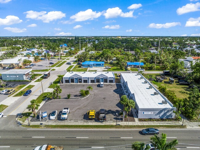


This Property Is For Sale
Current Lease Availabilities
Property Detail
525 E Olympia Ave
412306427003
WOODS 2ND ADD BLK L LTS 26 27 28 29 30 31 32 & 33 478/76 487/109 488/595 624/1318 658/358 UAG-900/1638 899/1649 V1521/1248 AFF4237/1686-JG 4552/1920 4954/1963 3434233
Storemultistory
Charlotte
NC
Florida
AE The base floodplain where base flood elevations are provided. AE Zones are now used on new format FIRMs instead of A1-A30 Zones.
26
2024
0.75 AC
2025
Charlotte County
010302
Southwest Florida
10,056 SF
Punta Gorda, FL
NEARBY LISTINGS FOR SALE OR LEASE
DEMOGRAPHICS near 525 E Olympia Ave
1 mile
3 mile
5 mile
2025 Total Population
2,837
26,041
71,207
2030 Population
3,130
28,710
78,141
Pop Growth 2025-2030
+ 10.33%
+ 10.25%
+ 9.74%
Average Age
50
57
55
2025 Total Households
1,404
13,016
33,600
HH Growth 2025-2030
+ 10.19%
+ 10.06%
+ 9.69%
Median Household Inc
$51,377
$73,108
$70,930
Avg Household Size
2.00
1.90
2.00
2025 Avg HH Vehicles
1.00
2.00
2.00
Median Home Value
$309,150
$420,531
$361,874
Median Year Built
1986
1992
1990
Nearby Places
Map Layers
Map Styles
 Street
 Aerial
Layers
 Traffic
 Biking
Places
Listings with unknown addresses are not visible on the map
- Restaurants
- Banks
- Shops
- Fitness
- Groceries
PUBLIC TRANSPORTATION
AIRPORT
Punta Gorda
Drive
Walk
Distance
Punta Gorda
9 min
4.8 mi
Freight Ports
Port Manatee
Drive
Walk
Distance
Port Manatee
84 min
72.1 mi
Nearby Properties
Address
Land Use
TOTAL SIZE
Lot Size
Zoning
Address
Land Use
TOTAL SIZE
Lot Size
Zoning
333,027 SF
9.79 AC
CHRW
Address
Land Use
TOTAL SIZE
Lot Size
Zoning
349,844 SF
78.47 AC
P
Address
Land Use
TOTAL SIZE
Lot Size
Zoning
164,121 SF
44.20 AC
ECAP
Address
Land Use
TOTAL SIZE
Lot Size
Zoning
77,154 SF
10.30 AC
CC
Address
Land Use
TOTAL SIZE
Lot Size
Zoning
161,439 SF
171 AC
RE1
Address
Land Use
TOTAL SIZE
Lot Size
Zoning
121,585 SF
696.03 AC
RE1
Address
Land Use
TOTAL SIZE
Lot Size
Zoning
345,043 SF
33.12 AC
ECAP
Address
Land Use
TOTAL SIZE
Lot Size
Zoning
172,298 SF
37.42 AC
OMI
Address
Land Use
TOTAL SIZE
Lot Size
Zoning
789,392 SF
31.39 AC
RMF15
Address
Land Use
TOTAL SIZE
Lot Size
Zoning
47,443 SF
7.94 AC
CC
Address
Land Use
TOTAL SIZE
Lot Size
Zoning
114,417 SF
4.36 AC
GM-15
Address
Land Use
TOTAL SIZE
Lot Size
Zoning
15,253 SF
13.27 AC
P
Address
Land Use
TOTAL SIZE
Lot Size
Zoning
208,560 SF
36.69 AC
PD-GM
Address
Land Use
TOTAL SIZE
Lot Size
Zoning
385,350 SF
374.81 AC
ECAP
Address
Land Use
TOTAL SIZE
Lot Size
Zoning
134,308 SF
16 AC
RSF3.5
Address
Land Use
TOTAL SIZE
Lot Size
Zoning
40,430 SF
5.63 AC
RMF12
Address
Land Use
TOTAL SIZE
Lot Size
Zoning
142,812 SF
7.89 AC
HC
Address
Land Use
TOTAL SIZE
Lot Size
Zoning
6,313 SF
15.49 AC
P
Address
Land Use
TOTAL SIZE
Lot Size
Zoning
73,095 SF
5 AC
NC
Address
Land Use
TOTAL SIZE
Lot Size
Zoning
44,185 SF
1.22 AC
CC
Address
Land Use
TOTAL SIZE
Lot Size
Zoning
128,594 SF
25.54 AC
PD
Address
Land Use
TOTAL SIZE
Lot Size
Zoning
25,356 SF
1.40 AC
CC
Address
Land Use
TOTAL SIZE
Lot Size
Zoning
70,518 SF
2.08 AC
PD
Address
Land Use
TOTAL SIZE
Lot Size
Zoning
82,379 SF
0.88 AC
CC
Address
Land Use
TOTAL SIZE
Lot Size
Zoning
12,159 SF
0.56 AC
CC
Address
Land Use
TOTAL SIZE
Lot Size
Zoning
24,880 SF
84.50 AC
PKR
Address
Land Use
TOTAL SIZE
Lot Size
Zoning
1,296 SF
14.46 AC
CG
Address
Land Use
TOTAL SIZE
Lot Size
Zoning
43,755 SF
8.19 AC
CC
Address
Land Use
TOTAL SIZE
Lot Size
Zoning
30,472 SF
3.19 AC
NR-10
Address
Land Use
TOTAL SIZE
Lot Size
Zoning
81,167 SF
5.63 AC
CG
The World's #1 Commercial Real Estate Marketplace
Connect with us
© 2026 CoStar Group
The information above has been obtained from sources believed reliable. While we do not doubt its accuracy we have not verified it and make no guarantee, warranty or representation about it. It is your responsibility to independently confirm its accuracy and completeness. Any projections, opinions, assumptions, or estimates used are for example only and do not represent the current or future performance of the property. The value of this transaction to you depends on tax and other factors which should be evaluated by your tax, financial, and legal advisors. You and your advisors should conduct a careful, independent investigation of the property to determine to your satisfaction the suitability of the property for your needs.