Property Record
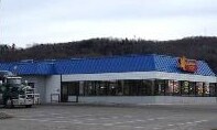
525 E State Highway M28, Munising, MI 49862

Property Detail
525 E State Highway M28
02-051-452-011-55
SEC 2 T46N R19W .92 A PT OF GL-2&3 COM AT S 1/4 COR OF SEC 2; TH S88DEG46'W 34.91'; TH N64DEG25'W 156.53' TO POB- TH N58DEG54
Commercialnec
ALGER
2025
Michigan
2025
0.92 AC
000100
Upper Peninsula
3,894 SF
Other Market Areas
NEARBY LISTINGS FOR SALE OR LEASE
-
-
View all Munising listings for sale on LoopNet.com
DEMOGRAPHICS near 525 E State Highway M28
1 mile
3 mile
5 mile
2025 Total Population
1,631
3,281
3,793
2030 Population
1,687
3,316
3,828
Pop Growth 2025-2030
+ 3.43%
+ 1.07%
+ 0.92%
Average Age
47
47
47
2025 Total Households
747
1,456
1,696
HH Growth 2025-2030
+ 3.21%
+ 0.96%
+ 0.77%
Median Household Inc
$55,466
$56,653
$57,229
Avg Household Size
2.00
2.10
2.10
2025 Avg HH Vehicles
1.00
2.00
2.00
Median Home Value
$150,824
$163,479
$166,372
Median Year Built
1964
1972
1973
Nearby Places
Map Layers
Map Styles
 Street
 Aerial
Transit
 Traffic
 Biking
Places
Listings with unknown addresses are not visible on the map
- Restaurants
- Banks
- Shops
- Fitness
- Groceries
Nearby Properties
Address
Land Use
TOTAL SIZE
Lot Size
Zoning
Address
Land Use
TOTAL SIZE
Lot Size
Zoning
311,385 SF
59.26 AC
Address
Land Use
TOTAL SIZE
Lot Size
Zoning
36,387 SF
3.50 AC
Address
Land Use
TOTAL SIZE
Lot Size
Zoning
46,225 SF
15.02 AC
Address
Land Use
TOTAL SIZE
Lot Size
Zoning
24,369 SF
2.24 AC
Address
Land Use
TOTAL SIZE
Lot Size
Zoning
Address
Land Use
TOTAL SIZE
Lot Size
Zoning
33,550 SF
4.74 AC
Address
Land Use
TOTAL SIZE
Lot Size
Zoning
1,738 SF
1.71 AC
Address
Land Use
TOTAL SIZE
Lot Size
Zoning
25,844 SF
1.06 AC
Address
Land Use
TOTAL SIZE
Lot Size
Zoning
Address
Land Use
TOTAL SIZE
Lot Size
Zoning
12,957 SF
0.90 AC
Address
Land Use
TOTAL SIZE
Lot Size
Zoning
Address
Land Use
TOTAL SIZE
Lot Size
Zoning
4,660 SF
3.63 AC
Address
Land Use
TOTAL SIZE
Lot Size
Zoning
6,880 SF
12.44 AC
Address
Land Use
TOTAL SIZE
Lot Size
Zoning
4,060 SF
0.62 AC
Address
Land Use
TOTAL SIZE
Lot Size
Zoning
2,651 SF
1.44 AC
Address
Land Use
TOTAL SIZE
Lot Size
Zoning
2,112 SF
1.28 AC
Address
Land Use
TOTAL SIZE
Lot Size
Zoning
4,898 SF
2.03 AC
Address
Land Use
TOTAL SIZE
Lot Size
Zoning
10,514 SF
0.38 AC
Address
Land Use
TOTAL SIZE
Lot Size
Zoning
1,992 SF
2.23 AC
Address
Land Use
TOTAL SIZE
Lot Size
Zoning
9,100 SF
2.35 AC
Address
Land Use
TOTAL SIZE
Lot Size
Zoning
14,560 SF
0.71 AC
Address
Land Use
TOTAL SIZE
Lot Size
Zoning
6,684 SF
0.70 AC
Address
Land Use
TOTAL SIZE
Lot Size
Zoning
3,013 SF
0.50 AC
Address
Land Use
TOTAL SIZE
Lot Size
Zoning
8,400 SF
0.86 AC
Address
Land Use
TOTAL SIZE
Lot Size
Zoning
2,936 SF
0.84 AC
Address
Land Use
TOTAL SIZE
Lot Size
Zoning
6,052 SF
0.28 AC
Address
Land Use
TOTAL SIZE
Lot Size
Zoning
8,901 SF
0.59 AC
Address
Land Use
TOTAL SIZE
Lot Size
Zoning
3,024 SF
0.65 AC
Address
Land Use
TOTAL SIZE
Lot Size
Zoning
4,050 SF
0.72 AC
The World's #1 Commercial Real Estate Marketplace
Connect with us
© 2026 CoStar Group
The information above has been obtained from sources believed reliable. While we do not doubt its accuracy we have not verified it and make no guarantee, warranty or representation about it. It is your responsibility to independently confirm its accuracy and completeness. Any projections, opinions, assumptions, or estimates used are for example only and do not represent the current or future performance of the property. The value of this transaction to you depends on tax and other factors which should be evaluated by your tax, financial, and legal advisors. You and your advisors should conduct a careful, independent investigation of the property to determine to your satisfaction the suitability of the property for your needs.