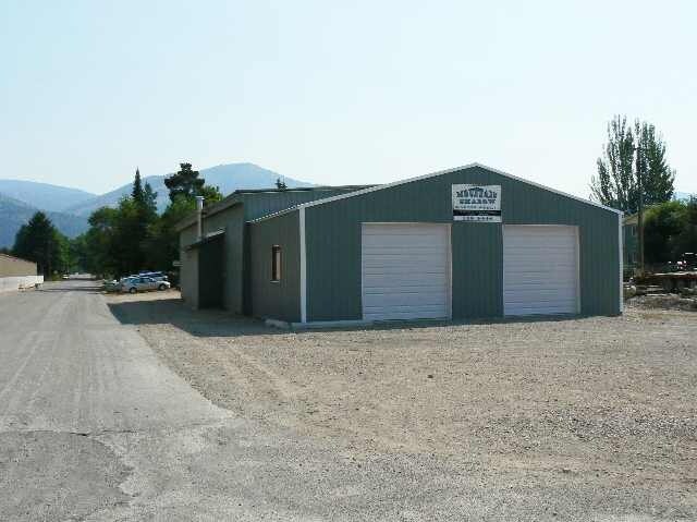
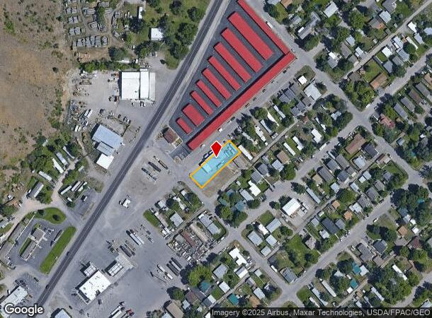
Property Record
525 Michigan Ave, Missoula, MT 59802
NEARBY LISTINGS FOR SALE OR LEASE
Property Detail
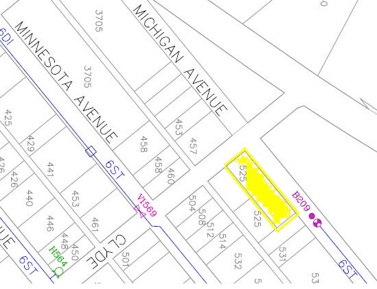
525 Michigan Ave
04-2200-24-1-27-15-0000
East Missoula Addition # 18
Commercialnec
EAST MISSOULA ADDITION # 18, S24, T13 N, R19 W, LOT 13A
X
Missoula
30063C1480E
Montana
2024
13a
2025
0.28 AC
000400
Other Market Areas
3,781 SF
Missoula, MT
DEMOGRAPHICS near 525 Michigan Ave
1 Mile
3 Mile
5 Mile
2024 Total Population
2,960
24,637
66,301
2029 Population
3,184
26,577
71,552
Pop Growth 2024-2029
+ 7.57%
+ 7.87%
+ 7.92%
Average Age
41
38
38
2024 Total Households
1,314
10,973
30,564
HH Growth 2024-2029
+ 7.69%
+ 8.10%
+ 8.14%
Median Household Inc
$65,307
$60,993
$55,630
Avg Household Size
2.20
2.00
2.00
2024 Avg HH Vehicles
2.00
2.00
2.00
Median Home Value
$308,571
$454,551
$364,491
Median Year Built
1977
1973
1977
Nearby Places
Map Layers
Map Styles
 Street
 Aerial
- Restaurants
- Banks
- Shops
- Fitness
- Groceries
PUBLIC TRANSPORTATION
AIRPORT
Missoula Montana
DRIVE
WALK
Distance
Missoula Montana
14 min
9.3 mi
Freight Ports
Port of Everett
DRIVE
WALK
Distance
Port of Everett
551 min
501.1 mi
Nearby Properties
Address
Land Use
TOTAL SIZE
Lot Size
Zoning
Address
Land Use
TOTAL SIZE
Lot Size
Zoning
227,454 SF
2.89 AC
2
Address
Land Use
TOTAL SIZE
Lot Size
Zoning
321,769 SF
6.14 AC
1
Address
Land Use
TOTAL SIZE
Lot Size
Zoning
19.46 AC
3
Address
Land Use
TOTAL SIZE
Lot Size
Zoning
130,966 SF
1.06 AC
6
Address
Land Use
TOTAL SIZE
Lot Size
Zoning
28,161 SF
0.31 AC
6
Address
Land Use
TOTAL SIZE
Lot Size
Zoning
104,592 SF
3.36 AC
6
Address
Land Use
TOTAL SIZE
Lot Size
Zoning
73,411 SF
0.68 AC
6
Address
Land Use
TOTAL SIZE
Lot Size
Zoning
131,066 SF
9.14 AC
1
Address
Land Use
TOTAL SIZE
Lot Size
Zoning
66,900 SF
0.25 AC
6
Address
Land Use
TOTAL SIZE
Lot Size
Zoning
131,532 SF
5.59 AC
1
Address
Land Use
TOTAL SIZE
Lot Size
Zoning
24,126 SF
1.19 AC
Address
Land Use
TOTAL SIZE
Lot Size
Zoning
30,436 SF
0.18 AC
6
Address
Land Use
TOTAL SIZE
Lot Size
Zoning
14.32 AC
1
Address
Land Use
TOTAL SIZE
Lot Size
Zoning
75,289 SF
5.86 AC
1
Address
Land Use
TOTAL SIZE
Lot Size
Zoning
60,592 SF
6.76 AC
1
Address
Land Use
TOTAL SIZE
Lot Size
Zoning
54,630 SF
0.99 AC
6
Address
Land Use
TOTAL SIZE
Lot Size
Zoning
36,572 SF
0.35 AC
6
Address
Land Use
TOTAL SIZE
Lot Size
Zoning
10.08 AC
Address
Land Use
TOTAL SIZE
Lot Size
Zoning
63,368 SF
1.71 AC
7
Address
Land Use
TOTAL SIZE
Lot Size
Zoning
54,816 SF
1.43 AC
Address
Land Use
TOTAL SIZE
Lot Size
Zoning
48,882 SF
0.45 AC
7
Address
Land Use
TOTAL SIZE
Lot Size
Zoning
46,790 SF
4.26 AC
1
Address
Land Use
TOTAL SIZE
Lot Size
Zoning
79,463 SF
4.92 AC
1
Address
Land Use
TOTAL SIZE
Lot Size
Zoning
52,986 SF
1.70 AC
2
Address
Land Use
TOTAL SIZE
Lot Size
Zoning
24.42 AC
Address
Land Use
TOTAL SIZE
Lot Size
Zoning
43,338 SF
2.31 AC
Address
Land Use
TOTAL SIZE
Lot Size
Zoning
28,456 SF
25 AC
Address
Land Use
TOTAL SIZE
Lot Size
Zoning
45,042 SF
0.38 AC
6
Address
Land Use
TOTAL SIZE
Lot Size
Zoning
31,456 SF
2.70 AC
1
Address
Land Use
TOTAL SIZE
Lot Size
Zoning
25,658 SF
3.86 AC
5
The World's #1 Commercial Real Estate Marketplace
Connect with us
© 2025 CoStar Group
The information above has been obtained from sources believed reliable. While we do not doubt its accuracy we have not verified it and make no guarantee, warranty or representation about it. It is your responsibility to independently confirm its accuracy and completeness. Any projections, opinions, assumptions, or estimates used are for example only and do not represent the current or future performance of the property. The value of this transaction to you depends on tax and other factors which should be evaluated by your tax, financial, and legal advisors. You and your advisors should conduct a careful, independent investigation of the property to determine to your satisfaction the suitability of the property for your needs.