Property Record
525 N Columbia River Hwy, Saint Helens, OR 97051
NEARBY LISTINGS FOR SALE OR LEASE
-
-
View all Saint Helens listings for sale on LoopNet.com
Property Detail
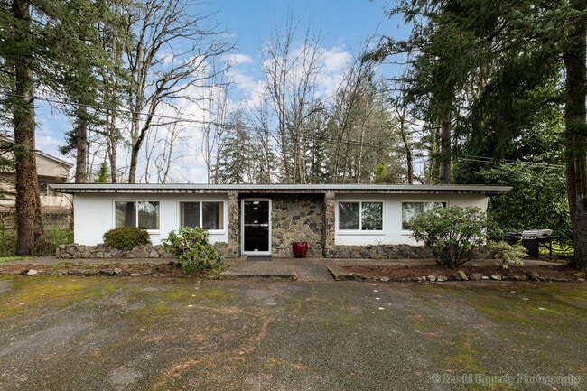
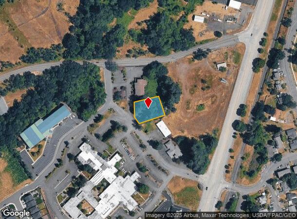
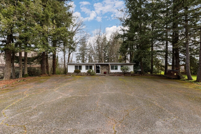
525 N Columbia River Hwy
Medicalbuilding
Columbia
X
Oregon
53015C0980G
0.38 AC
2025
Columbia County
2025
Portland
970800
Portland-Vancouver-Hillsboro, OR-WA
1,564 SF
0201041040210330000
DEMOGRAPHICS near 525 N Columbia River Hwy
1 Mile
3 Mile
5 Mile
2024 Total Population
10,551
20,218
28,752
2029 Population
11,170
21,362
30,277
Pop Growth 2024-2029
+ 5.87%
+ 5.66%
+ 5.30%
Average Age
40
41
41
2024 Total Households
4,154
7,775
10,789
HH Growth 2024-2029
+ 5.83%
+ 5.63%
+ 5.32%
Median Household Inc
$70,955
$76,933
$77,596
Avg Household Size
2.50
2.50
2.60
2024 Avg HH Vehicles
2.00
2.00
2.00
Median Home Value
$302,381
$353,532
$383,679
Median Year Built
1975
1978
1978
Nearby Places
Map Layers
Map Styles
 Street
 Aerial
- Restaurants
- Banks
- Shops
- Fitness
- Groceries
PUBLIC TRANSPORTATION
AIRPORT
Portland International
DRIVE
WALK
Distance
Portland International
64 min
34.5 mi
Freight Ports
Port of Kalama, WA
DRIVE
WALK
Distance
Port of Kalama, WA
50 min
33.1 mi
SALE & LEASE HISTORY
LISTING DATE
SALE/LEASE

Mar 20, 2024
For Sale
Nearby Properties
Address
Land Use
TOTAL SIZE
Lot Size
Zoning
Address
Land Use
TOTAL SIZE
Lot Size
Zoning
7.31 AC
SH:LI
Address
Land Use
TOTAL SIZE
Lot Size
Zoning
92,593 SF
7.72 AC
SH:GC
Address
Land Use
TOTAL SIZE
Lot Size
Zoning
52.02 AC
SH:PL
Address
Land Use
TOTAL SIZE
Lot Size
Zoning
89,327 SF
10.39 AC
SH:GC
Address
Land Use
TOTAL SIZE
Lot Size
Zoning
10 SF
10.57 AC
SH:GC
Address
Land Use
TOTAL SIZE
Lot Size
Zoning
1.11 AC
Address
Land Use
TOTAL SIZE
Lot Size
Zoning
4.71 AC
SH:HI
Address
Land Use
TOTAL SIZE
Lot Size
Zoning
18.15 AC
SH:HI
Address
Land Use
TOTAL SIZE
Lot Size
Zoning
38,596 SF
2.55 AC
SH:HC
Address
Land Use
TOTAL SIZE
Lot Size
Zoning
57,763 SF
2.39 AC
SH:R7
Address
Land Use
TOTAL SIZE
Lot Size
Zoning
19.79 AC
SH:HI
Address
Land Use
TOTAL SIZE
Lot Size
Zoning
36.02 AC
SH:HI
Address
Land Use
TOTAL SIZE
Lot Size
Zoning
39,958 SF
145.24 AC
CO:M-1
Address
Land Use
TOTAL SIZE
Lot Size
Zoning
42,120 SF
2.32 AC
SH:HC
Address
Land Use
TOTAL SIZE
Lot Size
Zoning
63,982 SF
3.66 AC
SH:AR
Address
Land Use
TOTAL SIZE
Lot Size
Zoning
19.79 AC
Address
Land Use
TOTAL SIZE
Lot Size
Zoning
38.35 AC
CO:CS-I
Address
Land Use
TOTAL SIZE
Lot Size
Zoning
20.83 AC
SH:HI
Address
Land Use
TOTAL SIZE
Lot Size
Zoning
16,618 SF
1.57 AC
SH:HC
Address
Land Use
TOTAL SIZE
Lot Size
Zoning
67,774 SF
4.03 AC
CC:C
Address
Land Use
TOTAL SIZE
Lot Size
Zoning
64,035 SF
5.02 AC
CO:M-2
Address
Land Use
TOTAL SIZE
Lot Size
Zoning
14,199 SF
1.52 AC
SH:HC
Address
Land Use
TOTAL SIZE
Lot Size
Zoning
53,915 SF
2.40 AC
SH:HC
Address
Land Use
TOTAL SIZE
Lot Size
Zoning
22,061 SF
1.82 AC
SH:HC
Address
Land Use
TOTAL SIZE
Lot Size
Zoning
57,576 SF
5.04 AC
SH:LI
Address
Land Use
TOTAL SIZE
Lot Size
Zoning
22,764 SF
2.63 AC
SH:GC
Address
Land Use
TOTAL SIZE
Lot Size
Zoning
22,528 SF
3.69 AC
CC:R-3
Address
Land Use
TOTAL SIZE
Lot Size
Zoning
10,520 SF
0.93 AC
SH:GC
Address
Land Use
TOTAL SIZE
Lot Size
Zoning
23,805 SF
1.59 AC
SH:HC
The World's #1 Commercial Real Estate Marketplace
Connect with us
© 2025 CoStar Group
The information above has been obtained from sources believed reliable. While we do not doubt its accuracy we have not verified it and make no guarantee, warranty or representation about it. It is your responsibility to independently confirm its accuracy and completeness. Any projections, opinions, assumptions, or estimates used are for example only and do not represent the current or future performance of the property. The value of this transaction to you depends on tax and other factors which should be evaluated by your tax, financial, and legal advisors. You and your advisors should conduct a careful, independent investigation of the property to determine to your satisfaction the suitability of the property for your needs.