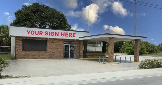
Property Record
525 N Us Highway 1, Fort Pierce, FL 34950

NEARBY LISTINGS FOR SALE OR LEASE
Property Detail
525 N Us Highway 1
Port St Lucie, FL
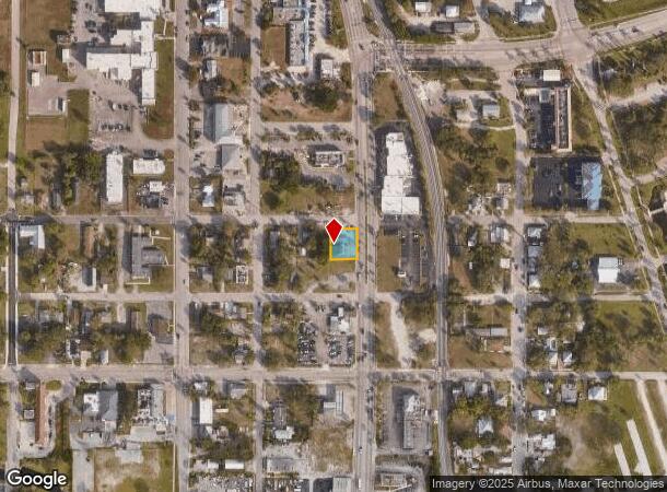
Assessors Map Of N Part Of Fort Pierce
24-03-705-0147-0009
ASSESSOR`S MAP OF N PART OF FT PIERCE BLK 17-L- LOTS 2 AND 4 (MAP24/10C)
Officebuilding
St Lucie
X
Florida
12111C0179K
2
2024
0.20 AC
2025
Fort Pierce
380100
Port St Lucie/Fort Pierce
1,999 SF
DEMOGRAPHICS near 525 N Us Highway 1
1 Mile
3 Mile
5 Mile
2024 Total Population
7,002
52,304
75,169
2029 Population
8,465
63,281
91,478
Pop Growth 2024-2029
+ 20.89%
+ 20.99%
+ 21.70%
Average Age
37
40
42
2024 Total Households
2,605
19,831
29,648
HH Growth 2024-2029
+ 20.27%
+ 21.06%
+ 21.78%
Median Household Inc
$23,490
$41,088
$45,617
Avg Household Size
2.50
2.50
2.40
2024 Avg HH Vehicles
1.00
1.00
2.00
Median Home Value
$160,546
$221,905
$249,911
Median Year Built
1963
1976
1980
Nearby Places
Map Layers
Map Styles
 Street
 Aerial
- Restaurants
- Banks
- Shops
- Fitness
- Groceries
SALE & LEASE HISTORY
LISTING DATE
SALE/LEASE

Mar 28, 2024
For Lease
Apr 01, 2024
For Lease
Nearby Properties
Address
Land Use
TOTAL SIZE
Lot Size
Zoning
Address
Land Use
TOTAL SIZE
Lot Size
Zoning
206,371 SF
22.36 AC
OFFICE CO
Address
Land Use
TOTAL SIZE
Lot Size
Zoning
352,224 SF
52.44 AC
SF INTERME
Address
Land Use
TOTAL SIZE
Lot Size
Zoning
282,450 SF
68.87 AC
INDUSTRIAL
Address
Land Use
TOTAL SIZE
Lot Size
Zoning
262,922 SF
24.60 AC
GENERAL CO
Address
Land Use
TOTAL SIZE
Lot Size
Zoning
149,072 SF
33.27 AC
MEDIUM DEN
Address
Land Use
TOTAL SIZE
Lot Size
Zoning
3,240 SF
45.25 AC
INSTITUTIO
Address
Land Use
TOTAL SIZE
Lot Size
Zoning
11.78 AC
COMM RESOR
Address
Land Use
TOTAL SIZE
Lot Size
Zoning
128,427 SF
25.89 AC
MEDIUM DEN
Address
Land Use
TOTAL SIZE
Lot Size
Zoning
66,153 SF
24.36 AC
GENERAL &
Address
Land Use
TOTAL SIZE
Lot Size
Zoning
51,838 SF
1.62 AC
CENTRAL CO
Address
Land Use
TOTAL SIZE
Lot Size
Zoning
69,970 SF
2.54 AC
GENERAL CO
Address
Land Use
TOTAL SIZE
Lot Size
Zoning
13,280 SF
12.46 AC
GENERAL &
Address
Land Use
TOTAL SIZE
Lot Size
Zoning
30,097 SF
6.37 AC
GENERAL CO
Address
Land Use
TOTAL SIZE
Lot Size
Zoning
213,311 SF
20.41 AC
INDUSTRIAL
Address
Land Use
TOTAL SIZE
Lot Size
Zoning
17,273 SF
13.49 AC
GENERAL &
Address
Land Use
TOTAL SIZE
Lot Size
Zoning
276,524 SF
53.32 AC
SF LOW DEN
Address
Land Use
TOTAL SIZE
Lot Size
Zoning
55,046 SF
1.86 AC
GENERAL CO
Address
Land Use
TOTAL SIZE
Lot Size
Zoning
Address
Land Use
TOTAL SIZE
Lot Size
Zoning
7,708 SF
0.93 AC
TOURIST CO
Address
Land Use
TOTAL SIZE
Lot Size
Zoning
1,440 SF
28.47 AC
PUD
Address
Land Use
TOTAL SIZE
Lot Size
Zoning
31,915 SF
2.86 AC
MEDIUM DEN
Address
Land Use
TOTAL SIZE
Lot Size
Zoning
58,331 SF
11.31 AC
MEDIUM DEN
Address
Land Use
TOTAL SIZE
Lot Size
Zoning
0.02 AC
Address
Land Use
TOTAL SIZE
Lot Size
Zoning
6,622 SF
67.17 AC
INSTITUTIO
Address
Land Use
TOTAL SIZE
Lot Size
Zoning
1,000 SF
3.73 AC
GENERAL &
Address
Land Use
TOTAL SIZE
Lot Size
Zoning
23.21 AC
PUD
Address
Land Use
TOTAL SIZE
Lot Size
Zoning
12,517 SF
5.85 AC
GENERAL &
Address
Land Use
TOTAL SIZE
Lot Size
Zoning
61,642 SF
8.46 AC
MEDIUM DEN
Address
Land Use
TOTAL SIZE
Lot Size
Zoning
117,205 SF
8.65 AC
MEDIUM DEN
Address
Land Use
TOTAL SIZE
Lot Size
Zoning
92,208 SF
16.80 AC
MEDIUM DEN
The World's #1 Commercial Real Estate Marketplace
Connect with us
© 2025 CoStar Group
The information above has been obtained from sources believed reliable. While we do not doubt its accuracy we have not verified it and make no guarantee, warranty or representation about it. It is your responsibility to independently confirm its accuracy and completeness. Any projections, opinions, assumptions, or estimates used are for example only and do not represent the current or future performance of the property. The value of this transaction to you depends on tax and other factors which should be evaluated by your tax, financial, and legal advisors. You and your advisors should conduct a careful, independent investigation of the property to determine to your satisfaction the suitability of the property for your needs.