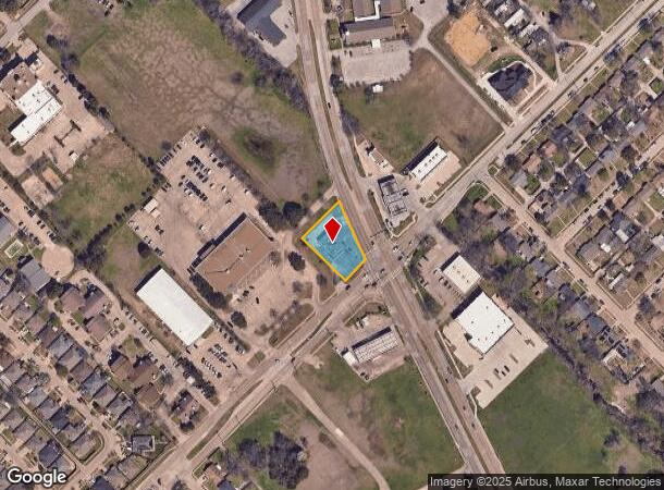
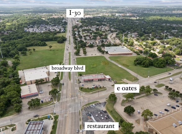
Property Record
525 E Oates Rd, Garland, TX 75043
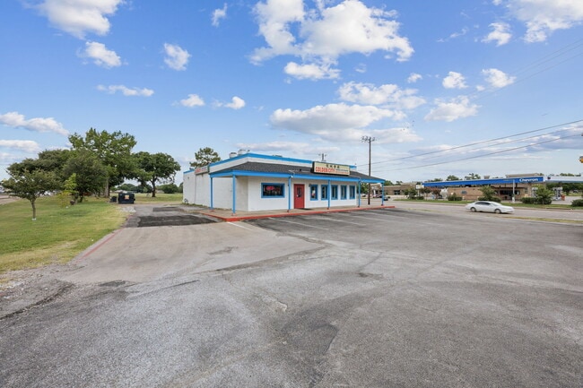
This Property Is For Sale
NEARBY LISTINGS FOR SALE OR LEASE
Property Detail
525 E Oates Rd
Dallas-Fort Worth-Arlington, TX
Rose Hill Acreage Homesites
60179500000340100
ROSE HILL ACREAGE HOMESITES PT LOTS 33 & 34 ACS 0.508 INT201800264909 DD10012018 CO-DC 1795000003401 32617950000
Restaurantbuilding
Dallas
X
Texas
48257C0025E
33,34
2024
0.51 AC
2025
Garland
018128
Dallas/Ft Worth
2,990 SF
DEMOGRAPHICS near 525 E Oates Rd
1 Mile
3 Mile
5 Mile
2024 Total Population
16,061
111,883
266,561
2029 Population
15,804
110,342
263,449
Pop Growth 2024-2029
(1.60%)
(1.38%)
(1.17%)
Average Age
36
37
37
2024 Total Households
5,280
38,104
89,739
HH Growth 2024-2029
(1.76%)
(1.56%)
(1.35%)
Median Household Inc
$57,793
$63,534
$63,034
Avg Household Size
3.00
2.90
2.90
2024 Avg HH Vehicles
2.00
2.00
2.00
Median Home Value
$219,712
$224,613
$217,920
Median Year Built
1978
1979
1977
Nearby Places
- Restaurants
- Banks
- Shops
- Fitness
- Groceries
PUBLIC TRANSPORTATION
AIRPORT
Dallas Love Field
DRIVE
WALK
Distance
Dallas Love Field
31 min
19.1 mi
Dallas-Fort Worth International
DRIVE
WALK
Distance
Dallas-Fort Worth International
41 min
33.4 mi
Nearby Properties
Address
Land Use
TOTAL SIZE
Lot Size
Zoning
Address
Land Use
TOTAL SIZE
Lot Size
Zoning
351,901 SF
11.84 AC
Z239
Address
Land Use
TOTAL SIZE
Lot Size
Zoning
441,557 SF
20.14 AC
Z239
Address
Land Use
TOTAL SIZE
Lot Size
Zoning
491,903 SF
22.48 AC
Z164
Address
Land Use
TOTAL SIZE
Lot Size
Zoning
336,685 SF
18.51 AC
Z85
Address
Land Use
TOTAL SIZE
Lot Size
Zoning
336,035 SF
21.78 AC
Z160
Address
Land Use
TOTAL SIZE
Lot Size
Zoning
236,812 SF
13.91 AC
Z237
Address
Land Use
TOTAL SIZE
Lot Size
Zoning
298,038 SF
9.06 AC
Z59
Address
Land Use
TOTAL SIZE
Lot Size
Zoning
224,063 SF
13.51 AC
Z10
Address
Land Use
TOTAL SIZE
Lot Size
Zoning
268,152 SF
13.86 AC
Z52
Address
Land Use
TOTAL SIZE
Lot Size
Zoning
197,284 SF
10.70 AC
Z02
Address
Land Use
TOTAL SIZE
Lot Size
Zoning
388,800 SF
28.99 AC
Z122
Address
Land Use
TOTAL SIZE
Lot Size
Zoning
177,784 SF
19.51 AC
Z237
Address
Land Use
TOTAL SIZE
Lot Size
Zoning
190,106 SF
12.31 AC
Z160
Address
Land Use
TOTAL SIZE
Lot Size
Zoning
249,764 SF
11.43 AC
Z237
Address
Land Use
TOTAL SIZE
Lot Size
Zoning
229,054 SF
12.36 AC
Z160
Address
Land Use
TOTAL SIZE
Lot Size
Zoning
212,801 SF
25.64 AC
Z237
Address
Land Use
TOTAL SIZE
Lot Size
Zoning
198,374 SF
10.86 AC
Z237
Address
Land Use
TOTAL SIZE
Lot Size
Zoning
262,647 SF
10.48 AC
Z164
Address
Land Use
TOTAL SIZE
Lot Size
Zoning
249,000 SF
9 AC
Z164
Address
Land Use
TOTAL SIZE
Lot Size
Zoning
231,526 SF
9.61 AC
Z237
Address
Land Use
TOTAL SIZE
Lot Size
Zoning
210,375 SF
7.54 AC
Address
Land Use
TOTAL SIZE
Lot Size
Zoning
173,559 SF
12.66 AC
Z160
Address
Land Use
TOTAL SIZE
Lot Size
Zoning
0.12 AC
Z63
Address
Land Use
TOTAL SIZE
Lot Size
Zoning
226,117 SF
9.71 AC
A3
Address
Land Use
TOTAL SIZE
Lot Size
Zoning
138,865 SF
11.38 AC
Z239
Address
Land Use
TOTAL SIZE
Lot Size
Zoning
195,817 SF
9.28 AC
Z160
Address
Land Use
TOTAL SIZE
Lot Size
Zoning
218,400 SF
8.12 AC
Z164
Address
Land Use
TOTAL SIZE
Lot Size
Zoning
210,086 SF
9.46 AC
Z237
Address
Land Use
TOTAL SIZE
Lot Size
Zoning
126,465 SF
10.09 AC
Z239
Address
Land Use
TOTAL SIZE
Lot Size
Zoning
133,249 SF
9.71 AC
Z239
The World's #1 Commercial Real Estate Marketplace
Connect with us
© 2025 CoStar Group
The information above has been obtained from sources believed reliable. While we do not doubt its accuracy we have not verified it and make no guarantee, warranty or representation about it. It is your responsibility to independently confirm its accuracy and completeness. Any projections, opinions, assumptions, or estimates used are for example only and do not represent the current or future performance of the property. The value of this transaction to you depends on tax and other factors which should be evaluated by your tax, financial, and legal advisors. You and your advisors should conduct a careful, independent investigation of the property to determine to your satisfaction the suitability of the property for your needs.