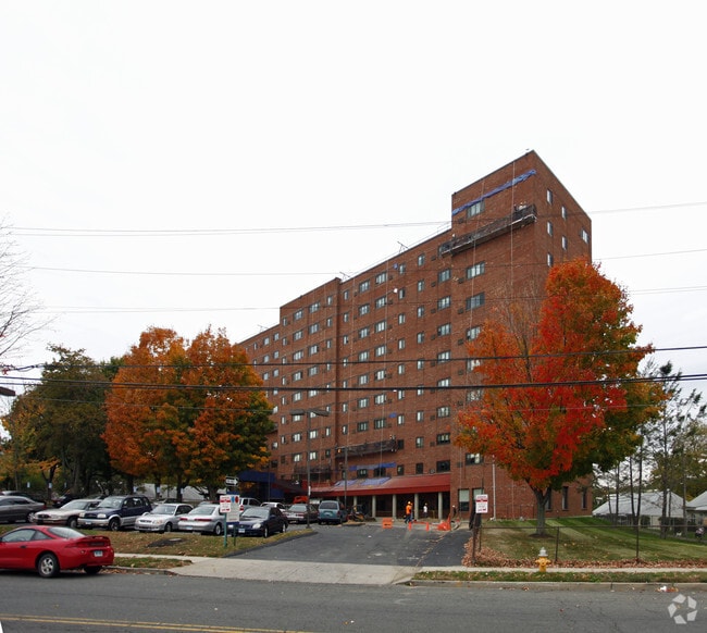
Property Record
525 Palisade Ave, Bridgeport, CT 06610

NEARBY LISTINGS FOR SALE OR LEASE
Property Detail
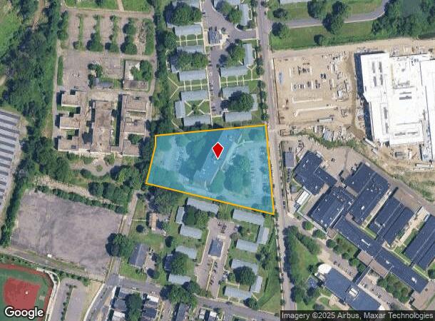
525 Palisade Ave
BRID-002044-000001Z
Fairfield
Apartmenthouse100plusunits
Connecticut
X
1-z
09001C0433G
3.13 AC
2025
North Bridgeport
2025
Westchester/So Connecticut
073200
Bridgeport-Stamford-Norwalk, CT
155,018 SF
DEMOGRAPHICS near 525 Palisade Ave
1 Mile
3 Mile
5 Mile
2024 Total Population
31,825
168,460
270,121
2029 Population
31,992
168,154
270,568
Pop Growth 2024-2029
+ 0.52%
(0.18%)
+ 0.17%
Average Age
39
38
39
2024 Total Households
12,196
60,997
99,796
HH Growth 2024-2029
+ 0.66%
(0.22%)
+ 0.14%
Median Household Inc
$46,278
$55,671
$68,242
Avg Household Size
2.50
2.60
2.60
2024 Avg HH Vehicles
1.00
2.00
2.00
Median Home Value
$157,883
$242,475
$298,797
Median Year Built
1949
1951
1955
Nearby Places
Map Layers
Map Styles
 Street
 Aerial
- Restaurants
- Banks
- Shops
- Fitness
- Groceries
PUBLIC TRANSPORTATION
COMMUTER RAIL
Stratford Station (New Haven Line - Metro-North Commuter Railroad Company (Metro-North))
DRIVE
WALK
Distance
Stratford Station (New Haven Line - Metro-North Commuter Railroad Company (Metro-North))
6 min
3.0 mi
Bridgeport Station (New Haven Line - Shore Line East, Shore Line East - Shore Line East)
DRIVE
WALK
Distance
Bridgeport Station (New Haven Line - Shore Line East, Shore Line East - Shore Line East)
7 min
3.2 mi
AIRPORT
Tweed/New Haven
DRIVE
WALK
Distance
Tweed/New Haven
35 min
21.3 mi
Westchester County
DRIVE
WALK
Distance
Westchester County
58 min
37.2 mi
Long Island MacArthur
DRIVE
WALK
Distance
Long Island MacArthur
115 min
37.4 mi
Freight Ports
Port of New Haven
DRIVE
WALK
Distance
Port of New Haven
30 min
18.4 mi
SALE & LEASE HISTORY
LISTING DATE
SALE/LEASE

Sep 17, 2018
For Lease
Nearby Properties
Address
Land Use
TOTAL SIZE
Lot Size
Zoning
Address
Land Use
TOTAL SIZE
Lot Size
Zoning
8.24 AC
Address
Land Use
TOTAL SIZE
Lot Size
Zoning
Address
Land Use
TOTAL SIZE
Lot Size
Zoning
22.85 AC
Address
Land Use
TOTAL SIZE
Lot Size
Zoning
23.95 AC
RB
Address
Land Use
TOTAL SIZE
Lot Size
Zoning
145,000 SF
15.70 AC
ILI
Address
Land Use
TOTAL SIZE
Lot Size
Zoning
38.62 AC
Address
Land Use
TOTAL SIZE
Lot Size
Zoning
22,848 SF
16.84 AC
IL-2
Address
Land Use
TOTAL SIZE
Lot Size
Zoning
4.14 AC
MUEM
Address
Land Use
TOTAL SIZE
Lot Size
Zoning
178,265 SF
6.92 AC
Address
Land Use
TOTAL SIZE
Lot Size
Zoning
83,122 SF
4.39 AC
Address
Land Use
TOTAL SIZE
Lot Size
Zoning
288,875 SF
1.57 AC
MUEM
Address
Land Use
TOTAL SIZE
Lot Size
Zoning
497,430 SF
4.16 AC
DCB
Address
Land Use
TOTAL SIZE
Lot Size
Zoning
23 AC
RC
Address
Land Use
TOTAL SIZE
Lot Size
Zoning
162,376 SF
7.82 AC
Address
Land Use
TOTAL SIZE
Lot Size
Zoning
10.66 AC
ORR
Address
Land Use
TOTAL SIZE
Lot Size
Zoning
585,480 SF
3.66 AC
Address
Land Use
TOTAL SIZE
Lot Size
Zoning
493,114 SF
2.20 AC
DCB
Address
Land Use
TOTAL SIZE
Lot Size
Zoning
23.70 AC
RB
Address
Land Use
TOTAL SIZE
Lot Size
Zoning
92,318 SF
5.33 AC
Address
Land Use
TOTAL SIZE
Lot Size
Zoning
182,000 SF
12.10 AC
IL-2
Address
Land Use
TOTAL SIZE
Lot Size
Zoning
368,000 SF
18.69 AC
D-17
Address
Land Use
TOTAL SIZE
Lot Size
Zoning
216,972 SF
2.53 AC
DCB
Address
Land Use
TOTAL SIZE
Lot Size
Zoning
225,264 SF
28.22 AC
MC
Address
Land Use
TOTAL SIZE
Lot Size
Zoning
5.31 AC
RC
Address
Land Use
TOTAL SIZE
Lot Size
Zoning
79,739 SF
1.53 AC
PDD
Address
Land Use
TOTAL SIZE
Lot Size
Zoning
204,000 SF
1.84 AC
MUEM
Address
Land Use
TOTAL SIZE
Lot Size
Zoning
7.52 AC
RC
Address
Land Use
TOTAL SIZE
Lot Size
Zoning
110,506 SF
0.06 AC
RBB
Address
Land Use
TOTAL SIZE
Lot Size
Zoning
2.40 AC
DCB
Address
Land Use
TOTAL SIZE
Lot Size
Zoning
56,762 SF
13.34 AC
BZZ
The World's #1 Commercial Real Estate Marketplace
Connect with us
© 2025 CoStar Group
The information above has been obtained from sources believed reliable. While we do not doubt its accuracy we have not verified it and make no guarantee, warranty or representation about it. It is your responsibility to independently confirm its accuracy and completeness. Any projections, opinions, assumptions, or estimates used are for example only and do not represent the current or future performance of the property. The value of this transaction to you depends on tax and other factors which should be evaluated by your tax, financial, and legal advisors. You and your advisors should conduct a careful, independent investigation of the property to determine to your satisfaction the suitability of the property for your needs.