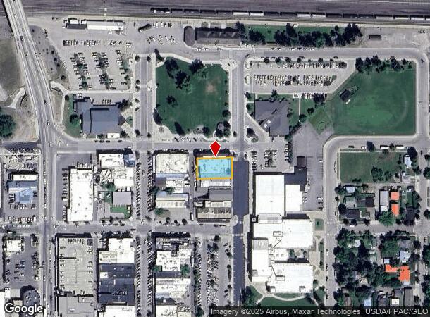
Property Record
525 Railway St, Whitefish, MT 59937

NEARBY LISTINGS FOR SALE OR LEASE
Property Detail
525 Railway St
Kalispell, MT
Chevy Court East
07-4292-36-1-08-01-0000
CHEVY COURT EAST, S36, T31 N, R22 W, LOT 1, ASSR #0000657546
Storebuilding
Flathead
X
Montana
30029C1090J
1
2025
0.23 AC
2025
Glacier Country
000402
Other Market Areas
17,379 SF
DEMOGRAPHICS near 525 Railway St
1 Mile
3 Mile
5 Mile
2024 Total Population
6,939
14,366
17,775
2029 Population
8,332
17,296
21,343
Pop Growth 2024-2029
+ 20.07%
+ 20.40%
+ 20.07%
Average Age
42
44
44
2024 Total Households
3,215
6,445
7,849
HH Growth 2024-2029
+ 20.00%
+ 20.28%
+ 19.98%
Median Household Inc
$67,461
$74,655
$75,337
Avg Household Size
2.10
2.20
2.20
2024 Avg HH Vehicles
2.00
2.00
2.00
Median Home Value
$624,405
$644,018
$634,761
Median Year Built
1990
1994
1993
Nearby Places
Map Layers
Map Styles
 Street
 Aerial
- Restaurants
- Banks
- Shops
- Fitness
- Groceries
PUBLIC TRANSPORTATION
COMMUTER RAIL
Whitefish Amtrak Station (Empire Builder - Amtrak)
DRIVE
WALK
Distance
Whitefish Amtrak Station (Empire Builder - Amtrak)
0 min
2 min
0.1 mi
AIRPORT
Glacier Park International
DRIVE
WALK
Distance
Glacier Park International
17 min
11.8 mi
Freight Ports
Port of Everett
DRIVE
WALK
Distance
Port of Everett
644 min
559.0 mi
SALE & LEASE HISTORY
LISTING DATE
SALE/LEASE

May 04, 2020
For Lease
Jun 22, 2017
For Sale
Jul 06, 2023
For Lease
Aug 18, 2023
For Lease
Nearby Properties
Address
Land Use
TOTAL SIZE
Lot Size
Zoning
Address
Land Use
TOTAL SIZE
Lot Size
Zoning
82,400 SF
25.75 AC
Address
Land Use
TOTAL SIZE
Lot Size
Zoning
118,500 SF
11.43 AC
Address
Land Use
TOTAL SIZE
Lot Size
Zoning
9.74 AC
Address
Land Use
TOTAL SIZE
Lot Size
Zoning
46,679 SF
0.69 AC
6
Address
Land Use
TOTAL SIZE
Lot Size
Zoning
100,320 SF
7.10 AC
1
Address
Land Use
TOTAL SIZE
Lot Size
Zoning
54,682 SF
5.80 AC
Address
Land Use
TOTAL SIZE
Lot Size
Zoning
135,347 SF
7.95 AC
Address
Land Use
TOTAL SIZE
Lot Size
Zoning
13,770 SF
60 AC
Address
Land Use
TOTAL SIZE
Lot Size
Zoning
50,306 SF
2.66 AC
Address
Land Use
TOTAL SIZE
Lot Size
Zoning
0.22 AC
Address
Land Use
TOTAL SIZE
Lot Size
Zoning
58,425 SF
2.96 AC
Address
Land Use
TOTAL SIZE
Lot Size
Zoning
52,259 SF
3.94 AC
Address
Land Use
TOTAL SIZE
Lot Size
Zoning
36,114 SF
2.36 AC
Address
Land Use
TOTAL SIZE
Lot Size
Zoning
0.38 AC
Address
Land Use
TOTAL SIZE
Lot Size
Zoning
52,630 SF
2.33 AC
Address
Land Use
TOTAL SIZE
Lot Size
Zoning
58,385 SF
4.20 AC
Address
Land Use
TOTAL SIZE
Lot Size
Zoning
10,681 SF
95.19 AC
Address
Land Use
TOTAL SIZE
Lot Size
Zoning
30,684 SF
8.34 AC
Address
Land Use
TOTAL SIZE
Lot Size
Zoning
0.22 AC
Address
Land Use
TOTAL SIZE
Lot Size
Zoning
0.15 AC
Address
Land Use
TOTAL SIZE
Lot Size
Zoning
57,230 SF
4.98 AC
Address
Land Use
TOTAL SIZE
Lot Size
Zoning
14,045 SF
5.42 AC
Address
Land Use
TOTAL SIZE
Lot Size
Zoning
25,400 SF
10.59 AC
Address
Land Use
TOTAL SIZE
Lot Size
Zoning
7,886 SF
0.15 AC
Address
Land Use
TOTAL SIZE
Lot Size
Zoning
13,872 SF
0.86 AC
6
Address
Land Use
TOTAL SIZE
Lot Size
Zoning
1,785 SF
103.25 AC
Address
Land Use
TOTAL SIZE
Lot Size
Zoning
17,538 SF
1.51 AC
1
Address
Land Use
TOTAL SIZE
Lot Size
Zoning
10,484 SF
1.50 AC
Address
Land Use
TOTAL SIZE
Lot Size
Zoning
41,249 SF
1.59 AC
Address
Land Use
TOTAL SIZE
Lot Size
Zoning
10,252 SF
0.85 AC
1
The World's #1 Commercial Real Estate Marketplace
Connect with us
© 2025 CoStar Group
The information above has been obtained from sources believed reliable. While we do not doubt its accuracy we have not verified it and make no guarantee, warranty or representation about it. It is your responsibility to independently confirm its accuracy and completeness. Any projections, opinions, assumptions, or estimates used are for example only and do not represent the current or future performance of the property. The value of this transaction to you depends on tax and other factors which should be evaluated by your tax, financial, and legal advisors. You and your advisors should conduct a careful, independent investigation of the property to determine to your satisfaction the suitability of the property for your needs.