Property Record
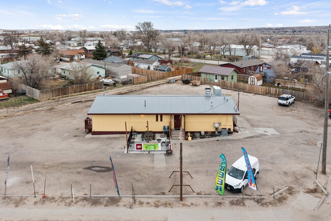
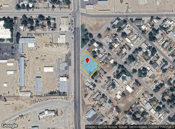
525 Sw Wyoming Blvd, Mills, WY 82644
NEARBY LISTINGS FOR SALE OR LEASE
Property Detail
525 Sw Wyoming Blvd
33-79-07-2-1-701000
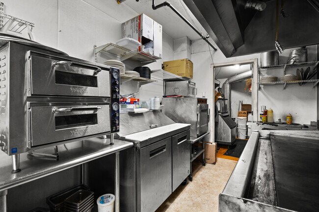
Baja Beach (Rplt Of Mills B 39 L 9-12
Bartavern
BAJA BEACH (RPLT OF MILLS B 39 L 9-12 INCL)
X
Natrona
56025C1985E
Wyoming
2024
0.57 AC
2025
I-25 Corridor/Casper
001100
Other Market Areas
1,860 SF
Casper, WY
DEMOGRAPHICS near 525 Sw Wyoming Blvd
1 Mile
3 Mile
5 Mile
2024 Total Population
2,874
30,179
59,844
2029 Population
2,857
30,590
60,741
Pop Growth 2024-2029
(0.59%)
+ 1.36%
+ 1.50%
Average Age
41
41
40
2024 Total Households
1,233
12,734
25,003
HH Growth 2024-2029
(0.65%)
+ 1.39%
+ 1.53%
Median Household Inc
$45,982
$58,217
$61,557
Avg Household Size
2.30
2.30
2.30
2024 Avg HH Vehicles
2.00
2.00
2.00
Median Home Value
$152,461
$208,996
$219,595
Median Year Built
1972
1968
1972
Nearby Places
Map Layers
Map Styles
 Street
 Aerial
- Restaurants
- Banks
- Shops
- Fitness
- Groceries
PUBLIC TRANSPORTATION
AIRPORT
Casper/Natrona County International
DRIVE
WALK
Distance
Casper/Natrona County International
24 min
12.0 mi
Freight Ports
Tulsa Port Of Catoosa
DRIVE
WALK
Distance
Tulsa Port Of Catoosa
997 min
980.6 mi
SALE & LEASE HISTORY
LISTING DATE
SALE/LEASE

Oct 10, 2022
For Sale
Nearby Properties
Address
Land Use
TOTAL SIZE
Lot Size
Zoning
Address
Land Use
TOTAL SIZE
Lot Size
Zoning
73,903 SF
31.44 AC
Address
Land Use
TOTAL SIZE
Lot Size
Zoning
156,457 SF
5.74 AC
Address
Land Use
TOTAL SIZE
Lot Size
Zoning
95,290 SF
0.57 AC
Address
Land Use
TOTAL SIZE
Lot Size
Zoning
99,524 SF
4.67 AC
Address
Land Use
TOTAL SIZE
Lot Size
Zoning
81,240 SF
5.86 AC
Address
Land Use
TOTAL SIZE
Lot Size
Zoning
166,099 SF
7.65 AC
Address
Land Use
TOTAL SIZE
Lot Size
Zoning
89,892 SF
2.75 AC
Address
Land Use
TOTAL SIZE
Lot Size
Zoning
225,342 SF
29.07 AC
Address
Land Use
TOTAL SIZE
Lot Size
Zoning
89,887 SF
5.46 AC
Address
Land Use
TOTAL SIZE
Lot Size
Zoning
88,739 SF
13.39 AC
Address
Land Use
TOTAL SIZE
Lot Size
Zoning
54,112 SF
3.52 AC
Address
Land Use
TOTAL SIZE
Lot Size
Zoning
24,240 SF
16.47 AC
Address
Land Use
TOTAL SIZE
Lot Size
Zoning
82,800 SF
5.94 AC
Address
Land Use
TOTAL SIZE
Lot Size
Zoning
56,433 SF
3 AC
Address
Land Use
TOTAL SIZE
Lot Size
Zoning
43,644 SF
3.35 AC
Address
Land Use
TOTAL SIZE
Lot Size
Zoning
45,297 SF
1.29 AC
Address
Land Use
TOTAL SIZE
Lot Size
Zoning
65,427 SF
2.16 AC
Address
Land Use
TOTAL SIZE
Lot Size
Zoning
51,699 SF
10.69 AC
Address
Land Use
TOTAL SIZE
Lot Size
Zoning
46,926 SF
9.56 AC
Address
Land Use
TOTAL SIZE
Lot Size
Zoning
25,200 SF
9.68 AC
Address
Land Use
TOTAL SIZE
Lot Size
Zoning
95,322 SF
2.01 AC
Address
Land Use
TOTAL SIZE
Lot Size
Zoning
38,983 SF
5.09 AC
Address
Land Use
TOTAL SIZE
Lot Size
Zoning
14,205 SF
3.01 AC
Address
Land Use
TOTAL SIZE
Lot Size
Zoning
58,661 SF
2.49 AC
Address
Land Use
TOTAL SIZE
Lot Size
Zoning
55,953 SF
1.94 AC
Address
Land Use
TOTAL SIZE
Lot Size
Zoning
29,143 SF
3.62 AC
Address
Land Use
TOTAL SIZE
Lot Size
Zoning
28,028 SF
12.99 AC
Address
Land Use
TOTAL SIZE
Lot Size
Zoning
19,695 SF
2.40 AC
Address
Land Use
TOTAL SIZE
Lot Size
Zoning
17,181 SF
0.38 AC
Address
Land Use
TOTAL SIZE
Lot Size
Zoning
39,061 SF
3.61 AC
The World's #1 Commercial Real Estate Marketplace
Connect with us
© 2025 CoStar Group
The information above has been obtained from sources believed reliable. While we do not doubt its accuracy we have not verified it and make no guarantee, warranty or representation about it. It is your responsibility to independently confirm its accuracy and completeness. Any projections, opinions, assumptions, or estimates used are for example only and do not represent the current or future performance of the property. The value of this transaction to you depends on tax and other factors which should be evaluated by your tax, financial, and legal advisors. You and your advisors should conduct a careful, independent investigation of the property to determine to your satisfaction the suitability of the property for your needs.