Property Record
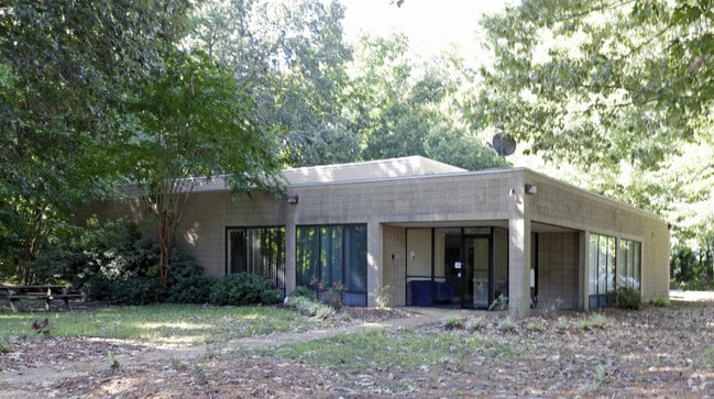
525 Viking Dr, Virginia Beach, VA 23452


NEARBY LISTINGS FOR SALE OR LEASE
Property Detail
525 Viking Dr
1496-58-3308-0001
525 Viking Drive A Condo
Industrialgeneral
OCEANA WEST INDUSTRIAL PARK PAR 19 3.00 ACRES CAM
X
Virginia Beach
5155310104G
Virginia
0
01900
2025
Lynnhaven
045407
Hampton Roads
10,233 SF
Virginia Beach-Norfolk-Newport News, VA-NC
DEMOGRAPHICS near 525 Viking Dr
1 Mile
3 Mile
5 Mile
2024 Total Population
5,898
86,190
232,588
2029 Population
5,832
85,142
230,351
Pop Growth 2024-2029
(1.12%)
(1.22%)
(0.96%)
Average Age
37
38
39
2024 Total Households
2,429
33,020
90,234
HH Growth 2024-2029
(1.32%)
(1.35%)
(1.05%)
Median Household Inc
$65,367
$70,655
$79,209
Avg Household Size
2.40
2.50
2.50
2024 Avg HH Vehicles
2.00
2.00
2.00
Median Home Value
$258,286
$262,147
$305,738
Median Year Built
1979
1977
1982
Nearby Places
Map Layers
Map Styles
 Street
 Aerial
- Restaurants
- Banks
- Shops
- Fitness
- Groceries
PUBLIC TRANSPORTATION
AIRPORT
Norfolk International
DRIVE
WALK
Distance
Norfolk International
24 min
13.9 mi
Freight Ports
Virginia Port Authority - Portsmouth
DRIVE
WALK
Distance
Virginia Port Authority - Portsmouth
31 min
18.9 mi
SALE & LEASE HISTORY
LISTING DATE
SALE/LEASE

Feb 20, 2025
For Sale
Nearby Properties
Address
Land Use
TOTAL SIZE
Lot Size
Zoning
Address
Land Use
TOTAL SIZE
Lot Size
Zoning
1,991 SF
201.95 AC
I2
Address
Land Use
TOTAL SIZE
Lot Size
Zoning
100 SF
13.35 AC
B2
Address
Land Use
TOTAL SIZE
Lot Size
Zoning
1 SF
44.31 AC
A18
Address
Land Use
TOTAL SIZE
Lot Size
Zoning
1 SF
24.56 AC
A18
Address
Land Use
TOTAL SIZE
Lot Size
Zoning
1 SF
25.89 AC
A18
Address
Land Use
TOTAL SIZE
Lot Size
Zoning
1 SF
30.13 AC
A18
Address
Land Use
TOTAL SIZE
Lot Size
Zoning
795,994 SF
52.17 AC
I1
Address
Land Use
TOTAL SIZE
Lot Size
Zoning
3 SF
13.58 AC
A12
Address
Land Use
TOTAL SIZE
Lot Size
Zoning
287,520 SF
13.10 AC
A18
Address
Land Use
TOTAL SIZE
Lot Size
Zoning
1 SF
18.64 AC
PDH1
Address
Land Use
TOTAL SIZE
Lot Size
Zoning
1 SF
0.02 AC
A18
Address
Land Use
TOTAL SIZE
Lot Size
Zoning
1 SF
0.01 AC
A18
Address
Land Use
TOTAL SIZE
Lot Size
Zoning
Address
Land Use
TOTAL SIZE
Lot Size
Zoning
219,000 SF
75.18 AC
I1
Address
Land Use
TOTAL SIZE
Lot Size
Zoning
358,274 SF
30.64 AC
B2
Address
Land Use
TOTAL SIZE
Lot Size
Zoning
252,686 SF
50.05 AC
PDH1
Address
Land Use
TOTAL SIZE
Lot Size
Zoning
1 SF
0.01 AC
A18
Address
Land Use
TOTAL SIZE
Lot Size
Zoning
150,339 SF
0.01 AC
B2
Address
Land Use
TOTAL SIZE
Lot Size
Zoning
1 SF
0.01 AC
A18
Address
Land Use
TOTAL SIZE
Lot Size
Zoning
1 SF
9.68 AC
A18
Address
Land Use
TOTAL SIZE
Lot Size
Zoning
190,955 SF
17.69 AC
A12
Address
Land Use
TOTAL SIZE
Lot Size
Zoning
117,195 SF
21.99 AC
R10
Address
Land Use
TOTAL SIZE
Lot Size
Zoning
1 SF
15.50 AC
PDH1
Address
Land Use
TOTAL SIZE
Lot Size
Zoning
1 SF
12.75 AC
A12
Address
Land Use
TOTAL SIZE
Lot Size
Zoning
1 SF
9.98 AC
A18
Address
Land Use
TOTAL SIZE
Lot Size
Zoning
775,440 SF
45.57 AC
I2
Address
Land Use
TOTAL SIZE
Lot Size
Zoning
1 SF
0.01 AC
A18
Address
Land Use
TOTAL SIZE
Lot Size
Zoning
1 SF
14.77 AC
A12
Address
Land Use
TOTAL SIZE
Lot Size
Zoning
196,053 SF
12.75 AC
I1
Address
Land Use
TOTAL SIZE
Lot Size
Zoning
1 SF
8.61 AC
A24
The World's #1 Commercial Real Estate Marketplace
Connect with us
© 2026 CoStar Group
The information above has been obtained from sources believed reliable. While we do not doubt its accuracy we have not verified it and make no guarantee, warranty or representation about it. It is your responsibility to independently confirm its accuracy and completeness. Any projections, opinions, assumptions, or estimates used are for example only and do not represent the current or future performance of the property. The value of this transaction to you depends on tax and other factors which should be evaluated by your tax, financial, and legal advisors. You and your advisors should conduct a careful, independent investigation of the property to determine to your satisfaction the suitability of the property for your needs.