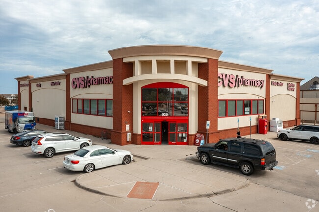
Property Record
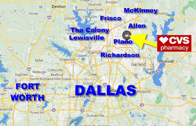
525 W Parker Rd, Plano, TX 75023

Property Detail
525 W Parker Rd
R-0616-001-002R-1
UNITED NATIONAL BANK ADDITION, BLK 1, LOT 2R; REPLAT
Commercialnec
COLLIN
LC
Texas
B and X Area of moderate flood hazard, usually the area between the limits of the 100-year and 500-year floods.
2r
2025
1.88 AC
2025
Central Plano
031611
Dallas/Ft Worth
12,900 SF
Dallas-Fort Worth-Arlington, TX
NEARBY LISTINGS FOR SALE OR LEASE
DEMOGRAPHICS near 525 W Parker Rd
1 mile
3 mile
5 mile
2024 Total Population
14,877
128,059
340,267
2029 Population
16,791
145,093
383,254
Pop Growth 2024-2029
+ 12.87%
+ 13.30%
+ 12.63%
Average Age
39
40
40
2024 Total Households
5,377
50,402
129,868
HH Growth 2024-2029
+ 13.04%
+ 13.64%
+ 13.06%
Median Household Inc
$93,551
$95,619
$106,775
Avg Household Size
2.70
2.50
2.50
2024 Avg HH Vehicles
2.00
2.00
2.00
Median Home Value
$342,973
$410,979
$473,015
Median Year Built
1983
1986
1992
Nearby Places
Map Layers
Map Styles
 Street
 Aerial
Transit
 Traffic
 Biking
Places
Listings with unknown addresses are not visible on the map
- Restaurants
- Banks
- Shops
- Fitness
- Groceries
PUBLIC TRANSPORTATION
TRANSIT/SUBWAY
Parker Rd (Orange Line - Dallas Area Rapid Transit (DART), Red Line - Dallas Area Rapid Transit (DART))
Drive
Walk
Distance
Parker Rd (Orange Line - Dallas Area Rapid Transit (DART), Red Line - Dallas Area Rapid Transit (DART))
3 min
16 min
0.9 mi
AIRPORT
Dallas Love Field
Drive
Walk
Distance
Dallas Love Field
30 min
21.7 mi
Dallas-Fort Worth International
Drive
Walk
Distance
Dallas-Fort Worth International
37 min
29.7 mi
Freight Ports
Port of Shreveport
Drive
Walk
Distance
Port of Shreveport
225 min
207.9 mi
SALE & LEASE HISTORY
LISTING DATE
SALE/LEASE

Sep 09, 2025
For Lease
Nov 09, 2022
For Sale
Jun 08, 2022
For Sale
Nearby Properties
Address
Land Use
TOTAL SIZE
Lot Size
Zoning
Address
Land Use
TOTAL SIZE
Lot Size
Zoning
1,049,441 SF
Address
Land Use
TOTAL SIZE
Lot Size
Zoning
1,283,376 SF
11.62 AC
Address
Land Use
TOTAL SIZE
Lot Size
Zoning
453,635 SF
19.04 AC
RT
Address
Land Use
TOTAL SIZE
Lot Size
Zoning
567,715 SF
4.75 AC
LC/PD-A
Address
Land Use
TOTAL SIZE
Lot Size
Zoning
1,105,509 SF
92.46 AC
A
Address
Land Use
TOTAL SIZE
Lot Size
Zoning
606,071 SF
64.75 AC
SFR
Address
Land Use
TOTAL SIZE
Lot Size
Zoning
384,538 SF
2.63 AC
LI-1
Address
Land Use
TOTAL SIZE
Lot Size
Zoning
490,285 SF
29.66 AC
LC/PD-A
Address
Land Use
TOTAL SIZE
Lot Size
Zoning
341,492 SF
25.20 AC
SFR
Address
Land Use
TOTAL SIZE
Lot Size
Zoning
528,996 SF
26.35 AC
R
Address
Land Use
TOTAL SIZE
Lot Size
Zoning
442,484 SF
APTS
Address
Land Use
TOTAL SIZE
Lot Size
Zoning
377,152 SF
3.91 AC
O-S
Address
Land Use
TOTAL SIZE
Lot Size
Zoning
509,566 SF
34.05 AC
PD
Address
Land Use
TOTAL SIZE
Lot Size
Zoning
289,093 SF
8.87 AC
R/O-2
Address
Land Use
TOTAL SIZE
Lot Size
Zoning
284,830 SF
2.98 AC
Address
Land Use
TOTAL SIZE
Lot Size
Zoning
324,000 SF
6.67 AC
O-S
Address
Land Use
TOTAL SIZE
Lot Size
Zoning
617,776 SF
97.53 AC
A
Address
Land Use
TOTAL SIZE
Lot Size
Zoning
421,532 SF
4.29 AC
Address
Land Use
TOTAL SIZE
Lot Size
Zoning
308,854 SF
16.62 AC
Address
Land Use
TOTAL SIZE
Lot Size
Zoning
445,959 SF
4.55 AC
MF-E
Address
Land Use
TOTAL SIZE
Lot Size
Zoning
296,337 SF
3.28 AC
Address
Land Use
TOTAL SIZE
Lot Size
Zoning
64.94 AC
Address
Land Use
TOTAL SIZE
Lot Size
Zoning
355,408 SF
3.08 AC
LI-1
Address
Land Use
TOTAL SIZE
Lot Size
Zoning
460,233 SF
10.31 AC
CC
Address
Land Use
TOTAL SIZE
Lot Size
Zoning
417,173 SF
4.48 AC
O-S
Address
Land Use
TOTAL SIZE
Lot Size
Zoning
284,231 SF
3.95 AC
MF-E
Address
Land Use
TOTAL SIZE
Lot Size
Zoning
400,049 SF
34.67 AC
MF-L
Address
Land Use
TOTAL SIZE
Lot Size
Zoning
457,656 SF
23.19 AC
MF-H
Address
Land Use
TOTAL SIZE
Lot Size
Zoning
297,331 SF
3.77 AC
Address
Land Use
TOTAL SIZE
Lot Size
Zoning
216,665 SF
12.17 AC
The World's #1 Commercial Real Estate Marketplace
Connect with us
© 2026 CoStar Group
The information above has been obtained from sources believed reliable. While we do not doubt its accuracy we have not verified it and make no guarantee, warranty or representation about it. It is your responsibility to independently confirm its accuracy and completeness. Any projections, opinions, assumptions, or estimates used are for example only and do not represent the current or future performance of the property. The value of this transaction to you depends on tax and other factors which should be evaluated by your tax, financial, and legal advisors. You and your advisors should conduct a careful, independent investigation of the property to determine to your satisfaction the suitability of the property for your needs.