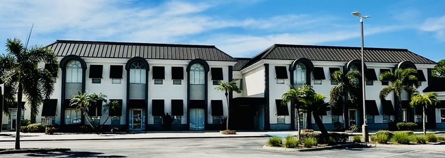
Property Record
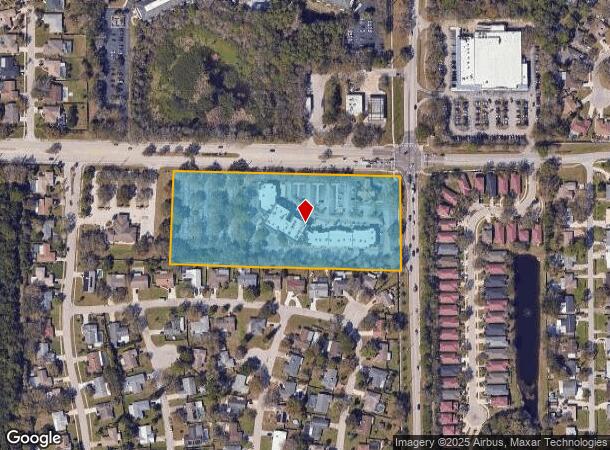
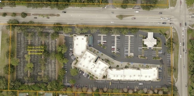
5250 17Th St, Sarasota, FL 34235

Current Lease Availabilities
NEARBY LISTINGS FOR SALE OR LEASE
Property Detail
5250 17Th St
0040-01-0001
Not Part Of A Subdivision
Officebuilding
COM NE COR OF SE 1/4 OF SEC 14-36-18 TH S 50.03 FT TH N-88-02-50-W 60.03 FT FOR POB TH S 325 FT TH N-88-02-50-W 809.57 FT TH N-01-57-10-E 324.81 FT TH S-88-02-50-E 798.58 FT TO POB, SUB TO
X
Sarasota
12115C0152G
Florida
2024
6 AC
2025
Sarasota
001301
Tampa/St Petersburg
44,831 SF
North Port-Sarasota-Bradenton, FL
DEMOGRAPHICS near 5250 17Th St
1 Mile
3 Mile
5 Mile
2024 Total Population
7,288
55,313
171,044
2029 Population
8,417
63,489
196,516
Pop Growth 2024-2029
+ 15.49%
+ 14.78%
+ 14.89%
Average Age
51
47
47
2024 Total Households
3,539
24,723
76,239
HH Growth 2024-2029
+ 15.46%
+ 14.81%
+ 14.81%
Median Household Inc
$67,133
$68,983
$71,052
Avg Household Size
1.90
2.10
2.10
2024 Avg HH Vehicles
2.00
2.00
2.00
Median Home Value
$295,032
$290,432
$331,456
Median Year Built
1986
1984
1985
Nearby Places
Map Layers
Map Styles
 Street
 Aerial
- Restaurants
- Banks
- Shops
- Fitness
- Groceries
PUBLIC TRANSPORTATION
AIRPORT
Sarasota/Bradenton International
DRIVE
WALK
Distance
Sarasota/Bradenton International
18 min
8.5 mi
Nearby Properties
Address
Land Use
TOTAL SIZE
Lot Size
Zoning
Address
Land Use
TOTAL SIZE
Lot Size
Zoning
668,194 SF
45.91 AC
CG
Address
Land Use
TOTAL SIZE
Lot Size
Zoning
92,398 SF
178.58 AC
OUE1
Address
Land Use
TOTAL SIZE
Lot Size
Zoning
434,419 SF
49.04 AC
CG
Address
Land Use
TOTAL SIZE
Lot Size
Zoning
617,341 SF
76.40 AC
PD-MU
Address
Land Use
TOTAL SIZE
Lot Size
Zoning
359,089 SF
16.72 AC
PCD
Address
Land Use
TOTAL SIZE
Lot Size
Zoning
343,100 SF
13.67 AC
VPD
Address
Land Use
TOTAL SIZE
Lot Size
Zoning
332,686 SF
37.78 AC
VPD
Address
Land Use
TOTAL SIZE
Lot Size
Zoning
486,203 SF
40.94 AC
RMF3
Address
Land Use
TOTAL SIZE
Lot Size
Zoning
318,350 SF
14.30 AC
ILW
Address
Land Use
TOTAL SIZE
Lot Size
Zoning
415,689 SF
37.52 AC
OPI
Address
Land Use
TOTAL SIZE
Lot Size
Zoning
350,210 SF
13.36 AC
PED
Address
Land Use
TOTAL SIZE
Lot Size
Zoning
268,645 SF
9.38 AC
VPD
Address
Land Use
TOTAL SIZE
Lot Size
Zoning
334,284 SF
30.55 AC
RMF3
Address
Land Use
TOTAL SIZE
Lot Size
Zoning
349,363 SF
22.58 AC
VPD
Address
Land Use
TOTAL SIZE
Lot Size
Zoning
352,070 SF
8.87 AC
ILW
Address
Land Use
TOTAL SIZE
Lot Size
Zoning
326,645 SF
17.96 AC
RMF3
Address
Land Use
TOTAL SIZE
Lot Size
Zoning
358,441 SF
31.80 AC
PD-R
Address
Land Use
TOTAL SIZE
Lot Size
Zoning
313,441 SF
26.91 AC
RSF2
Address
Land Use
TOTAL SIZE
Lot Size
Zoning
216,684 SF
30.52 AC
RMF2
Address
Land Use
TOTAL SIZE
Lot Size
Zoning
374,477 SF
15.55 AC
PED
Address
Land Use
TOTAL SIZE
Lot Size
Zoning
251,472 SF
11 AC
RSF2
Address
Land Use
TOTAL SIZE
Lot Size
Zoning
258,407 SF
18.55 AC
RMF3
Address
Land Use
TOTAL SIZE
Lot Size
Zoning
204,843 SF
27.48 AC
PCD
Address
Land Use
TOTAL SIZE
Lot Size
Zoning
209,091 SF
21.30 AC
RMF3
Address
Land Use
TOTAL SIZE
Lot Size
Zoning
206,788 SF
122.30 AC
GU
Address
Land Use
TOTAL SIZE
Lot Size
Zoning
195,342 SF
20.20 AC
CSC
Address
Land Use
TOTAL SIZE
Lot Size
Zoning
170,631 SF
23.70 AC
RMF2
Address
Land Use
TOTAL SIZE
Lot Size
Zoning
157,351 SF
10.98 AC
ILW
Address
Land Use
TOTAL SIZE
Lot Size
Zoning
109,470 SF
17.23 AC
RSF2
Address
Land Use
TOTAL SIZE
Lot Size
Zoning
118,713 SF
31.70 AC
MCI
The World's #1 Commercial Real Estate Marketplace
Connect with us
© 2025 CoStar Group
The information above has been obtained from sources believed reliable. While we do not doubt its accuracy we have not verified it and make no guarantee, warranty or representation about it. It is your responsibility to independently confirm its accuracy and completeness. Any projections, opinions, assumptions, or estimates used are for example only and do not represent the current or future performance of the property. The value of this transaction to you depends on tax and other factors which should be evaluated by your tax, financial, and legal advisors. You and your advisors should conduct a careful, independent investigation of the property to determine to your satisfaction the suitability of the property for your needs.