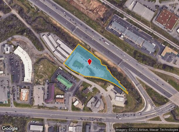
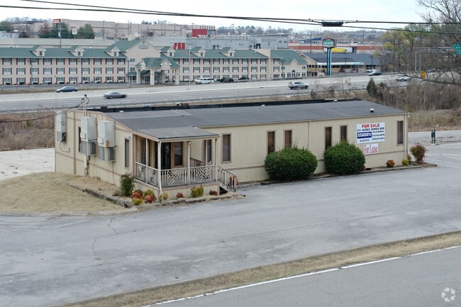
Property Record
5250 Cane Ridge Rd, Antioch, TN 37013

NEARBY LISTINGS FOR SALE OR LEASE
Property Detail
5250 Cane Ridge Rd
Nashville-Davidson--Murfreesboro--Franklin, TN
Guardian Storage Sub
163-00-0-312
LOT 1 GUARDIAN STORAGE SUB & PT CLSD R.O.W
Parkinglot
Davidson
AE
Tennessee
47037C0391H
1
2025
2.60 AC
2025
Airport South
019111
Nashville
DEMOGRAPHICS near 5250 Cane Ridge Rd
1 Mile
3 Mile
5 Mile
2024 Total Population
12,598
82,771
186,177
2029 Population
12,372
81,206
184,720
Pop Growth 2024-2029
(1.79%)
(1.89%)
(0.78%)
Average Age
34
35
36
2024 Total Households
5,065
29,630
68,695
HH Growth 2024-2029
(2.55%)
(2.28%)
(1.27%)
Median Household Inc
$67,500
$72,026
$78,758
Avg Household Size
2.40
2.70
2.60
2024 Avg HH Vehicles
2.00
2.00
2.00
Median Home Value
$338,210
$342,846
$383,897
Median Year Built
1993
1994
1992
Nearby Places
Map Layers
Map Styles
 Street
 Aerial
- Restaurants
- Banks
- Shops
- Fitness
- Groceries
PUBLIC TRANSPORTATION
AIRPORT
Nashville International
DRIVE
WALK
Distance
Nashville International
12 min
7.6 mi
Freight Ports
Port of Mobile
DRIVE
WALK
Distance
Port of Mobile
485 min
443.9 mi
Nearby Properties
Address
Land Use
TOTAL SIZE
Lot Size
Zoning
Address
Land Use
TOTAL SIZE
Lot Size
Zoning
272,894 SF
36.45 AC
MULTI-ZONE
Address
Land Use
TOTAL SIZE
Lot Size
Zoning
28,908 SF
21.55 AC
MULTIZONE
Address
Land Use
TOTAL SIZE
Lot Size
Zoning
157,123 SF
12.11 AC
SCR
Address
Land Use
TOTAL SIZE
Lot Size
Zoning
48,247 SF
Address
Land Use
TOTAL SIZE
Lot Size
Zoning
39,816 SF
39.02 AC
MULTIZONE
Address
Land Use
TOTAL SIZE
Lot Size
Zoning
57,362 SF
31.96 AC
MULTIZONE
Address
Land Use
TOTAL SIZE
Lot Size
Zoning
77,752 SF
13.44 AC
AR2A
Address
Land Use
TOTAL SIZE
Lot Size
Zoning
107,214 SF
13.78 AC
R10
Address
Land Use
TOTAL SIZE
Lot Size
Zoning
17,304 SF
41.35 AC
R8
Address
Land Use
TOTAL SIZE
Lot Size
Zoning
27,734 SF
18.24 AC
RM20
Address
Land Use
TOTAL SIZE
Lot Size
Zoning
42,711 SF
18.42 AC
MULTIZONE
Address
Land Use
TOTAL SIZE
Lot Size
Zoning
18,707 SF
27.42 AC
RM15
Address
Land Use
TOTAL SIZE
Lot Size
Zoning
29,010 SF
16.19 AC
SP
Address
Land Use
TOTAL SIZE
Lot Size
Zoning
23,184 SF
24.15 AC
R15
Address
Land Use
TOTAL SIZE
Lot Size
Zoning
100,849 SF
13.59 AC
SP
Address
Land Use
TOTAL SIZE
Lot Size
Zoning
16,726 SF
26.98 AC
R15
Address
Land Use
TOTAL SIZE
Lot Size
Zoning
23,718 SF
15 AC
MULTI-ZONE
Address
Land Use
TOTAL SIZE
Lot Size
Zoning
15,388 SF
25.28 AC
R8
Address
Land Use
TOTAL SIZE
Lot Size
Zoning
27,189 SF
13.81 AC
MULTIZONE
Address
Land Use
TOTAL SIZE
Lot Size
Zoning
18,288 SF
41.06 AC
R10
Address
Land Use
TOTAL SIZE
Lot Size
Zoning
23,580 SF
34.80 AC
RM9
Address
Land Use
TOTAL SIZE
Lot Size
Zoning
6,912 SF
47.91 AC
R10
Address
Land Use
TOTAL SIZE
Lot Size
Zoning
25,260 SF
33.29 AC
MULTIZONE
Address
Land Use
TOTAL SIZE
Lot Size
Zoning
48,405 SF
16.72 AC
MULTI-ZONE
Address
Land Use
TOTAL SIZE
Lot Size
Zoning
32,898 SF
15.14 AC
MULTIZONE
Address
Land Use
TOTAL SIZE
Lot Size
Zoning
3,994 SF
29.93 AC
RM15
Address
Land Use
TOTAL SIZE
Lot Size
Zoning
10,236 SF
31.36 AC
R10
Address
Land Use
TOTAL SIZE
Lot Size
Zoning
53,810 SF
26.20 AC
MULTI-ZONE
Address
Land Use
TOTAL SIZE
Lot Size
Zoning
627,900 SF
55.57 AC
IWD
Address
Land Use
TOTAL SIZE
Lot Size
Zoning
200,101 SF
6.04 AC
MULTIZONE
The World's #1 Commercial Real Estate Marketplace
Connect with us
© 2025 CoStar Group
The information above has been obtained from sources believed reliable. While we do not doubt its accuracy we have not verified it and make no guarantee, warranty or representation about it. It is your responsibility to independently confirm its accuracy and completeness. Any projections, opinions, assumptions, or estimates used are for example only and do not represent the current or future performance of the property. The value of this transaction to you depends on tax and other factors which should be evaluated by your tax, financial, and legal advisors. You and your advisors should conduct a careful, independent investigation of the property to determine to your satisfaction the suitability of the property for your needs.