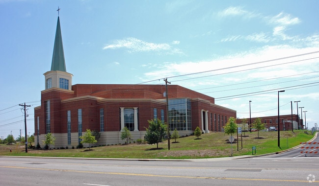
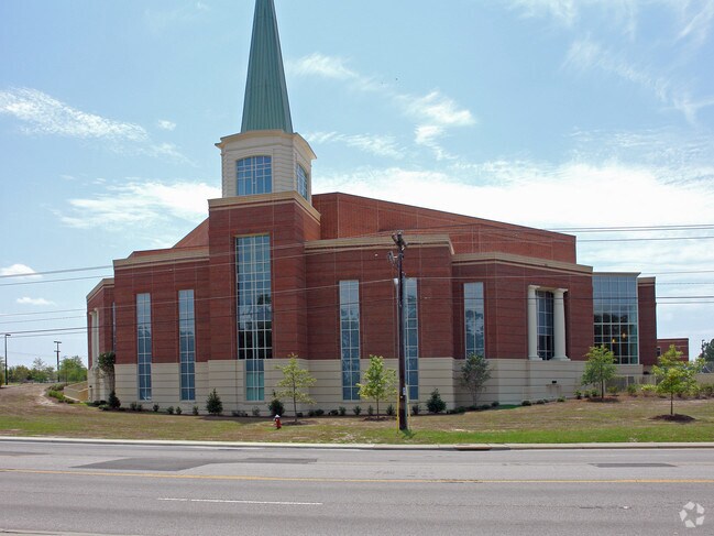
Property Record
5250 Forest Dr, Columbia, SC 29206

Property Detail
5250 Forest Dr
16705-01-48
TRACT I
Commercialnec
Richland
C-3
South Carolina
B and X Area of moderate flood hazard, usually the area between the limits of the 100-year and 500-year floods.
20 AC
2024
Forest Acres
2023
Columbia
002400
Columbia, SC
NEARBY LISTINGS FOR SALE OR LEASE
-
-
View all Columbia listings for sale on LoopNet.com
DEMOGRAPHICS near 5250 Forest Dr
1 mile
3 mile
5 mile
2025 Total Population
5,554
59,741
159,536
2030 Population
5,740
61,439
165,155
Pop Growth 2025-2030
+ 3.35%
+ 2.84%
+ 3.52%
Average Age
40
38
37
2025 Total Households
2,528
23,016
65,793
HH Growth 2025-2030
+ 3.36%
+ 3.08%
+ 3.82%
Median Household Inc
$79,469
$69,379
$53,145
Avg Household Size
2.20
2.20
2.10
2025 Avg HH Vehicles
2.00
2.00
2.00
Median Home Value
$441,124
$300,606
$247,853
Median Year Built
1977
1967
1972
Nearby Places
Map Layers
Map Styles
 Street
 Aerial
Layers
 Traffic
 Biking
Places
Listings with unknown addresses are not visible on the map
- Restaurants
- Banks
- Shops
- Fitness
- Groceries
PUBLIC TRANSPORTATION
COMMUTER RAIL
Drive
Walk
Distance
15 min
6.3 mi
AIRPORT
Columbia Metro
Drive
Walk
Distance
Columbia Metro
32 min
19.5 mi
Nearby Properties
Address
Land Use
TOTAL SIZE
Lot Size
Zoning
Address
Land Use
TOTAL SIZE
Lot Size
Zoning
316,116 SF
21.73 AC
RG-2
Address
Land Use
TOTAL SIZE
Lot Size
Zoning
1,704.85 AC
RU
Address
Land Use
TOTAL SIZE
Lot Size
Zoning
13,028 SF
31.69 AC
RG-1
Address
Land Use
TOTAL SIZE
Lot Size
Zoning
313,244 SF
12.75 AC
RM-HD
Address
Land Use
TOTAL SIZE
Lot Size
Zoning
216,180 SF
15.66 AC
C-1
Address
Land Use
TOTAL SIZE
Lot Size
Zoning
231,426 SF
10 AC
C-3
Address
Land Use
TOTAL SIZE
Lot Size
Zoning
169,291 SF
18.97 AC
C-3
Address
Land Use
TOTAL SIZE
Lot Size
Zoning
200,609 SF
17.97 AC
GC
Address
Land Use
TOTAL SIZE
Lot Size
Zoning
179,652 SF
14.98 AC
RM-HD
Address
Land Use
TOTAL SIZE
Lot Size
Zoning
9.66 AC
C-1
Address
Land Use
TOTAL SIZE
Lot Size
Zoning
129,721 SF
3.72 AC
C-3
Address
Land Use
TOTAL SIZE
Lot Size
Zoning
259,948 SF
14.40 AC
RM-HD
Address
Land Use
TOTAL SIZE
Lot Size
Zoning
202,048 SF
20.98 AC
C-3
Address
Land Use
TOTAL SIZE
Lot Size
Zoning
285,760 SF
16.12 AC
RG-2
Address
Land Use
TOTAL SIZE
Lot Size
Zoning
414,262 SF
34.45 AC
RM-HD
Address
Land Use
TOTAL SIZE
Lot Size
Zoning
23,379 SF
3.76 AC
M-1
Address
Land Use
TOTAL SIZE
Lot Size
Zoning
113,510 SF
11.60 AC
GC
Address
Land Use
TOTAL SIZE
Lot Size
Zoning
156,185 SF
12.68 AC
GC
Address
Land Use
TOTAL SIZE
Lot Size
Zoning
51,353 SF
7.01 AC
GC
Address
Land Use
TOTAL SIZE
Lot Size
Zoning
145,081 SF
22.36 AC
C-3
Address
Land Use
TOTAL SIZE
Lot Size
Zoning
97,683 SF
11.60 AC
C-3
Address
Land Use
TOTAL SIZE
Lot Size
Zoning
125,486 SF
9.97 AC
C-3
Address
Land Use
TOTAL SIZE
Lot Size
Zoning
89,639 SF
14.68 AC
C-3
Address
Land Use
TOTAL SIZE
Lot Size
Zoning
97,324 SF
9.29 AC
C-3
Address
Land Use
TOTAL SIZE
Lot Size
Zoning
3,960 SF
18.88 AC
RS-2
Address
Land Use
TOTAL SIZE
Lot Size
Zoning
117,920 SF
8.44 AC
RM-HD
Address
Land Use
TOTAL SIZE
Lot Size
Zoning
65,242 SF
10.17 AC
MU-2
Address
Land Use
TOTAL SIZE
Lot Size
Zoning
51,000 SF
6.25 AC
C-3
Address
Land Use
TOTAL SIZE
Lot Size
Zoning
91,543 SF
4.73 AC
C-1
The World's #1 Commercial Real Estate Marketplace
Connect with us
© 2026 CoStar Group
The information above has been obtained from sources believed reliable. While we do not doubt its accuracy we have not verified it and make no guarantee, warranty or representation about it. It is your responsibility to independently confirm its accuracy and completeness. Any projections, opinions, assumptions, or estimates used are for example only and do not represent the current or future performance of the property. The value of this transaction to you depends on tax and other factors which should be evaluated by your tax, financial, and legal advisors. You and your advisors should conduct a careful, independent investigation of the property to determine to your satisfaction the suitability of the property for your needs.